The Pembrokeshire Coast Path in Wales is one of the best long-distance walks in Britain. For 299 km (186 miles) it follows a spectacular coastline from Amroth to St Dogmaels. Expect dramatic sea cliffs, white sand beaches, wildflowers, seabirds, colourful seaside villages and harbours with character, along with a few historic castles and numerous ancient forts.
John and I hiked the full Pembrokeshire Coast Path over 14 days starting in early June. We only carried our daypack and had our luggage transferred to B&Bs. It wasn’t always easy as many days were long – up to 30 kilometres – and over the two weeks you climb and lose more elevation than Mount Everest. If you’ve ever hiked the Fisherman’s Trail in Portugal, you’ll find that this is similar experience, though there is more mileage and more elevation gain and loss.
In my guide, I share our 14-day itinerary, daily distances and elevation gain, highlights from each stage, useful planning advice, and helpful tips so you can decide if hiking the Pembrokeshire Coast Path is a fit for you.
This post includes affiliate links. If you make a qualifying purchase through one of these links, I may earn a small commission at no extra cost to you. Thank you for supporting my website.
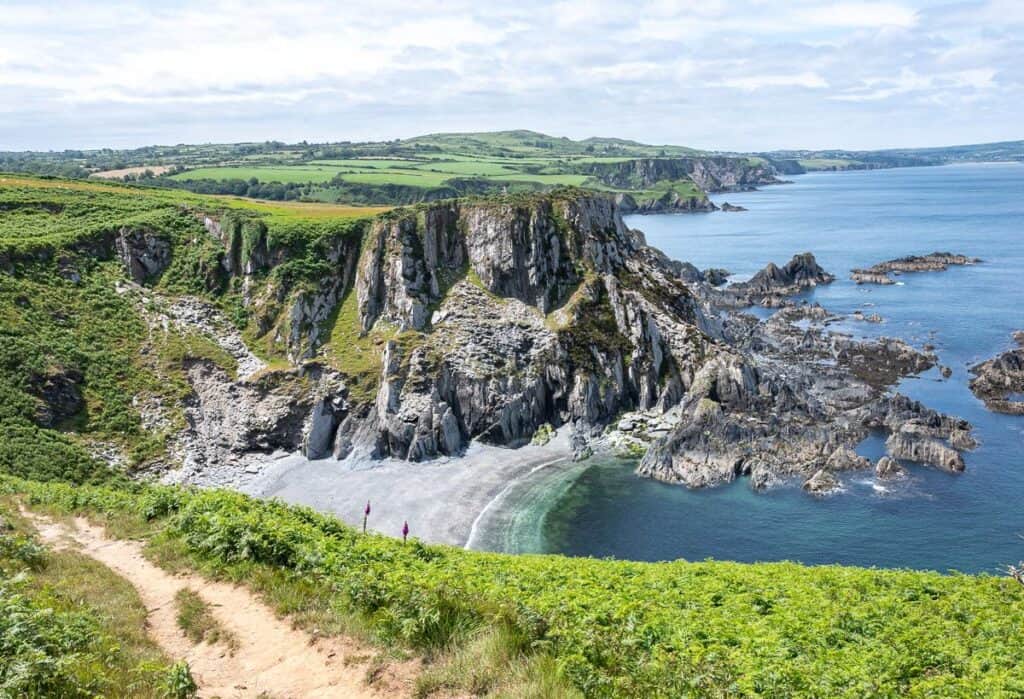
The Pembrokeshire Coast Path is spectacular on the hike north to Newport
Pembrokeshire Coast Path at a Glance
Start point: Amroth, Pembrokeshire
End point: St Dogmaels, Pembrokeshire
Highest point: 175m/ 574 feet
Total distance: 299 km/ 186 miles
Total elevation gain: Approximately 9,780 m/ 32,085 feet
Difficulty: Moderate to challenging depending on length of hiking day
Accommodation: Hotels, B&Bs, inns, guesthouses, a few hostels, campgrounds
Luggage transfer available: Yes
Best time to hike: May through September
Highlights: Tenby, Barafundle Bay, Broad Haven South, Skomer Island, St. David’s, Whitesands Bay, sense of accomplishment, trail camaraderie
Don’t forget: Pack the 10 hiking essentials and practice the seven Leave No Trace principles.
Trail map of the Pembrokeshire Coast Path from Amroth in the south to St Dogmaels in the north
Why Hike the Pembrokeshire Coast Path?
The 299-kilometre-long (186 miles) Pembrokeshire Coast Path is one of the best coastal trails in the world thanks to its world-class scenery that features rugged cliffs, more than 50 beautiful beaches, rocky coves, pastoral landscapes, and seaside Welsh towns and villages.
History lovers will relish seeing neolithic burial chambers, Norman castles, and Iron-Age promontory forts – while nature enthusiasts will enjoy looking for bottlenose dolphins and gray seals along with countless bird species including puffins – if you boat over to Skomer Island.
Hike up an down dramatic red cliffs going north to Bosherton
Who Will Love This Walk and Who Won’t
People that will love the Pembrokeshire Coast Path would be those that:
Love coastal scenery and are comfortable hiking beside airy cliffs
Birdwatchers
History buffs
Beach lovers
Hikers who enjoy oceanside cafes and Welsh-style pubs
Long-distance walkers
Hikers who enjoy constant elevation change
People who might dislike the coastal path include:
Hikers afraid of heights and airy paths
Hikers on a tight budget (especially with the British pound so high against other currencies)
Anyone who hates very windy weather
Those looking for big mountain scenery and/or remote wilderness
Hikers who don’t like a lot of elevation gain
Interesting to watch the waves at the beach by Newgale on the way to Solva
Highlights of Our Pembrokeshire Coast Path Hike
Some of the UK’s most picturesque beaches including Barafundle, Broad Haven, Whitesands, and Freshwater West
Great bird life
Dramatic coastal cliffs and formations especially on the northern section
Medieval and very colourful Tenby
Marloes Sands area
Skomer Island – an important seabird site (boat reservations required)
St. David’s – Britain’s smallest city with its spectacular 12thC Cathedral and Bishop’s Palace
Trail camaraderie
Lucky to have as many sunny, dry days as we did hiking the Pembrokeshire Coast Path in June
What to Know Before Hiking the Pembrokeshire Coast Path
Meals
All B&Bs and hotels we stayed in offered breakfast. We had lunch on the trail from supplies purchased in local stores. And we went out for dinner every night. It’s important to reserve a table in small places where there is only one place to stay and eat like St. Govan’s Inn. I’d recommend booking a table at restaurants on weekends, especially in the busier summer season.
Accommodation
In bigger centres like Tenby, St. David’s, and Solva, there is more choice when it comes to accommodation options. But book early wherever you go, especially in high season.
I’ve listed my favourite places we stayed at later in the blog.
Taxis and Buses
You may need a taxi at some point, so I do recommend that you carry a cell phone (with an e-sim card if you don’t live in the UK). Book a taxi days in advance if you know you’ll need one, especially if you have any distance to travel. Many of the towns have only one taxi and they just can’t handle much volume.
The Celtic Coaster is a great way to get around the St. David’s area. We used it getting to and from the trailhead at St. Justinians for £2.10 per person each way.
TrawsCymru is another long distance bus service. Some of the routes provide easy access to trailheads. Check out routes number T5 – Aberystwyth-Cardigan-Haverfordwest via Fishguard and T11 route – Haverfordwest-Fishguard via St. David’s.
There is also an on-demand bus service that allows you to book a ride that picks you up and drops you off directly along the coast or nearby hubs up to 30 days in advance. A lot of people we met were using it to hike sections of the Pembrokeshire Coast Path. It operates Monday to Saturday but bookings can be done any day of the week. Either download the Fflecsi App or call 0300 234 0300. Fares vary by distance – and they are much less expensive than using a taxi.
Navigation
There is a Wales Coast Path app – which we didn’t use but it might be useful to some of you. The Pembrokeshire Coast Path is part of the longer Wales Coast Path.
We used Organic Maps – a free, offline hiking app. The route was on it – and we tracked our distance and elevation gain every day. Most hiking apps should have the route on it. You could also try All Trails, Komoot, or Outdooractive.
Luggage Transfer
Walkalongway did an excellent job. We never once had to wait for our luggage. Bags can weigh no more than 18 kg or you get charged extra. Your bag needs to be ready for pick-up by 8:30 AM and they are always delivered by 5 PM.
Best Guidebook
We carried the Cicerone book – Walking the Pembrokeshire Coast Path. It comes with a map and very detailed day-to-day information that we rarely read. The path is very well-signed and marked, but some people might like the extra confidence of carrying a guidebook along with all the information provided.
Hike the Pembrokeshire Coast Trail in June for abundant wildflowers
When to Hike the Pembrokeshire Coast Path
Spring from April to May is ideal for coastal wildflowers and quiet trails. It’s also reportedly a drier time to visit. If you are a birder, it’s prime time for a visit to Skomer Island to see nesting seabirds like puffins and razorbills.
Summer from June to August is the warmest time to hike and there’s lots of daylight. It’s perfect if you’re after an afternoon swim. It’s also the busiest time, so prices go up and accommodation must be booked well in advance.
September can be a good time to hike with quieter trails and warm seas for swimming. It’s also the best time to see Atlantic grey seals and their pups on beaches.
Be prepared for Atlantic storms by the time October rolls around. From November to March you’ll need to deal with shorter daylight hours, solitude, colder temperatures and high winds – which wouldn’t be a lot of fun on top of the airy cliff sections.
Our 14-Day Pembrokeshire Coast Path Itinerary
Day 1: Amroth to Manorbier via Tenby
Distance: 24 km/ 14.9 miles
Elevation gain/loss: +930m/ -921 m
Time needed: 7 hours with breaks
Highlights
Hiking along an old railway and through abandoned railway tunnels
Saundersfoot – with cafes, ice cream and a pretty beach
Tenby Harbour view
Impressive views over to Caldey Island from Giltar Point
Thinking of today’s warfare and looking out to WWI practice trenches
Dramatic cliffs especially at Lydstep Point
Walking to the start of the Pembrokeshire Coast Path in Amroth
John pointing to our starting point in Amroth on the Pembrokeshire Coast Path
A blustery start to the Pembrokeshire Coast Path hike
Back to where the taxi dropped us off in Amroth – and no rain gear
Making quick time on a paved, flat section of trail on the way towards Tenby, Wales
Into oak woods on the Pembrokeshire Coast Path as we hike towards Tenby
Walking past colourful houses on the beach in Tenby
John hiking a long section of beach on the far side of Tenby
Note the live firing signage as you hike towards Manorbier fromTenby
Dramatic coastal scenery on the hike to Manorbier
Getting into more interesting hiking on the way to Manorbier
Day 2: Manorbier to Bosherston
Distance: 17 km/ 10.6 miles
Elevation gain/loss: +421m/-392 m
Time needed: 5.75 hours with breaks
Highlights
Dramatic red sandstone cliffs and coves
Barafundle Bay – sometimes voted as one of the world’s most beautiful beaches
Stackpole Head
Bosherton Lily Ponds – a national nature reserve known for its bird life, otters, and water lilies
One of the many beautiful beaches we passed on the way to Bosherton
Postcard worthy coastline on route to Bosherton
The soft white sand at Barafundle Beach along with easy access ensures its popularity
Cliff-top drama near Stackpole Head
John checking out the view from Stackpole Head
Exploring the Bosherton Lily Ponds
Day 3: Bosherston to Angle (Ideally via Stack Rocks)
Distance: 26 km/ 16.2 miles
Elevation gain/loss: +324 m/ – 346 m
Time needed: 7.75 hours with breaks
Highlights
Stack Rocks reportedly (we had to detour to Warren through fields because of military firing)
St. Govan’s Chapel – a tiny 14th-century hermitage cave wedged into the cliffs (which we missed)
Freshwater West Beach
Airy cliff-top walking towards Angle
Looking out to Thorne Island – a renovated Napoleonic Fort
Pass old tanks and the entrance to the Passing the Castlemartin training range
So many sheep and lambs to be seen in the fields along the path
Hiking up sand dunes as we leave Freshwater West Beach
Freshwater West Beach makes a great lunch stop
Give cows space along the Pembrokeshire Coast Path
A quiet, wilder section of the trail with airy clifftop walking on the way to Angle
Day 4: Angle to Pembroke
Distance: 16 km/ 10 miles
Elevation gain/loss: +226/ -280 m
Time needed: 5.5 hours with breaks
Highlights
Good bird life including wading birds
Walk beside Wales’ largest estuary, one of the deepest natural harbours in the world marveling at the infrastructure, tankers, and ships large tankers
Pwllcrochan Pond & Marshland – a peaceful pond even though its within sight of the refinery
We found a great place for lunch – Pwllcrochan Pond & Marshland – though within sight of the stacks
John hiking through a pretty section of forest on the way from Angle to Pembroke
Hiking past the Valero oil refinery on route to Pembroke
Day 5: Pembroke to Sandy Haven
Distance: 25.7 km/ 16 miles
Elevation gain/loss: 600m /1970 feet
Time needed: 7 hours with breaks
Highlights
Walking past swans at the pond at Pembroke Castle
Colouful town of Neyland
Finally leaving the industrial section of the path behind
Handsome Pembroke Castle in Pembroke
Walking across the Cleddau Bridge towards Neyland
Colourful houses in Neyland
Loved all the old stone walls we passed covered in colourful flowers
We’re ready to leave the area around the LNG plant behind
Finally past the industrial area and hiking north towards Sandy Haven
Day 6: Sandy Haven to Marloes Sands
Distance: 29 km/ 18 miles
Elevation gain/loss: +470m/-446 m
Time needed: 8.5 hours with breaks
Highlights
Hiking across the bay on stepping stones if you’re within 2.5 hours of low tide
Dramatic cliff-top views and wildflowers
Pretty seaside village of Dale
Marloes Sands
Some sections of the trail are very overgrown- though they do try to cut it back
We see the Irish ferry many times while hiking the path
Marloes Sands is one long, beautiful beach
Day 7: Marloes Sands Loop (Skomer Island)
Distance: 12 km/7.5 miles
Elevation gain/loss: +187 m/-188 m
Time needed: 4 hours with breaks
Skomer Island
We had set aside a day so we could visit Skomer Island. It’s a world-renowned National Nature Reserve – but only one boat company is able to land on it. I’d been told to book in advance – so I tried a month out and no luck. Booking in advance really means book on December 1st when it opens for the following spring and summer. There are also boat cruises of various durations but we opted instead to enjoy a hike at a leisurely pace – to make day 8 easier.
Highlights
Islands and dramatic cliffs looking out to Skomer Island
Gorgeous fields in a palette of yellows and greens
Watching an enormous number of gulls fly by
Hiking towards a lookout over to Skomer Island
Coming around to Skomer Island seen in the distance
People lined up to get on a boat tour to Skomer Island
Colourful pastoral scenes near Marloe Sands
Day 8: Marloes Sands to Broad Haven
Distance: 15 km/ 9.3 miles
Elevation gain/loss: +251 m/-290 m
Time needed: 4. 25 hours with breaks
Highlights
Stunning hiking in fields and along the coast
St Brides Haven Beach and Broad Haven Beach
Little Haven – a cute village
Beautiful coastal scenery on the hike to Broad Haven
Enjoyed a break at St Brides Haven beach – reportedly a favourite of divers
Peering over a cliff as we hike towards Broad Haven
Day 9: Broad Haven to Solva
Distance: 18 km/ 11.2 miles
Elevation gain/loss: +638m/ -633m
Time needed: 5.75 hours with breaks
Highlights
A lunch time stop just as it started to rain in a cafe in Nolton Haven
Beach walking
Splendid view of Newgale Sands
The pretty coastal village of Solva with its boat-filled harbour
Heading to Solva prepared for rain but we mostly got mist
Hiking a wiggly path as we head north towards Solva
We’ll drop down to the beach and walk it to Newgale
Enjoying this easy hiking on the way to Solva
We still have some up and down to reach Solva and its pretty harbour
Interesting to see a harbour full of boats at low tide in Solva
Day 10: Solva to St. Justinians
Distance: 17 km/ 10.6 miles
Elevation gain/loss: +316 m/-298 m
Time needed: 5 hours with breaks
Highlights
Exceptional cliff top walking and rocky coves
Pretty harbour in St. Justinians
Always cool to peer over the edge but I never liked to get very close
Heading north towards St Justinians from Solva
Day 11: St. Justinians to Trefin
Distance: 23 km/ 14.3 miles
Elevation gain/loss: +510 m/-476 m
Time needed: 7.25 hours with breaks
Highlights
Looking across to Ramsey Island – settled since early Christian times
Whitesands Beach and Bay
Coeatan Arthur Dolman
The hike towards Carn Llidi
Excellent seabird viewing
Hiking past sheer cliffs and through beautiful fields +fabulous rock formations
Blue Lagoon
Committed swimmers at Whitesands Bay
Coeatan Arthur Dolman – the remains of a Neolithic burial chamber – dates back to about 3000 BC
Heading towards Carn Llidi near St. David’s
Day 12: Trefin to Goodwick – Our Hardest Day
Day 12 was the hardest of the entire Pembrokeshire Coast Path for us. At 30 km with almost 700 m of elevation gain, it was physically demanding and the number of hours of hiking was long. But, it also delivered some of the trail’s most spectacular scenery, including Strumble Head, dramatic headlands, and the beautiful beaches of Abermawr and Aberbach.
Distance: 30 km/ 18.6 miles
Elevation gain/loss: +692 m/-709m
Time needed: 9.25 hours with breaks
Highlights
Picturesque Abercastle
Abermawr and Aberbach Beaches
Strumble Head Lighthouse – and the striking views on the hike to the lighthouse
Scenic repeating headlands north of Goodwick
The hike down to scenic Abercastle
Abermawr Beach
One of my favourite views along the Pembrokeshire Coast Path
Hiking towards Strumble Head and the lighthouse
Day 13: Goodwick to Newport
Distance: 23 km/ 14.3 miles
Elevation gain/loss: +492 m/-477m
Time needed: 7.5 hours with breaks
Highlights
Gorgeous and colourful Fishguard Harbour
Some of the most dramatic cliffs on the trail
Massive low tide near Newport – unlike anything I’ve seen before
Love this Seahorse sculpture we hiked past in Fishguard
Lower Town in Fishguard Harbour is very pretty
Going down and then right back up gain – a common theme on many days
Evidence of slumping on the Pembrokeshire Coast Path (roped off)
Watching fishers in Newport Bay
Day 14: Newport to St Dogmaels
Distance: 26 km/ 16.2 miles
Elevation gain/loss: +685m/ -695m
Time needed: 8.25 hours with breaks
Highlights
Very airy cliff top walking
Amazing geology and folded rocks
Dolphin sightings
Finishing the trail (though the last 5 km on road was underwhelming)
I felt like I was hiking through a painting leaving Newport
Closely following the coastline as we head north
Look down into the Witch’s Cauldron from the top of the stairs John is heading towards
A coastal rock that looks like a head to me
Nearing the end of the airy section along the Pembrokeshire Coastal Path on our last day of hiking
On the finish marker in a park in St Dogmael
And it’s a wrap – feeling quite pleased with ourselves but will miss the simplicity of simply hiking all day
Our Favourite Sections of the Pembrokeshire Coast Path
My favourite sections of the path are the following:
The hike around Stackpole Head
Colourful hiking with amazing cliff top views on the approach to Marloes Sands
The last day with the crazy folding in the rocks
Walking the length of Freshwater West Beach
Admiring the crazy tidal variation heading into Newport
The hike towards Stumblehead Lighthouse
Lucky to have a sunny day to enjoy this colourful section on the way north to Marloes Sands
The Most Beautiful Beaches on the Pembrokeshire Coast Path
There are officially 58 beaches on the Pembrokeshire Coast Path – so it’s hard to choose a favourite. A couple that stood out for me were Barafundle Beach, Whitesands Beach, and Freshwater West Beach.
Barafundle Beach
Freshwater West Beach is very popular as a swimming beach year round
Pass gorgeous Whitesands Bay as you head north towards Trefin
Facilities Along the Coastal Path
You’ll find shops, banks, pharmacies, and post offices in the following towns: Saundersfoot, Tenby, Pembroke, Pembroke Dock, Milford Haven, St. David’s, Fishguard. and Cardigan. Smaller villages along the hike might have a pub or two, local food shops, and occasionally an ATM.
Was the Pembrokeshire Coast Path Difficult?
The Pembrokeshire Coast Path is technically easy with no scrambling required – but it can be physically challenging. Some days are long (18 mi/30 km was our longest) because there just aren’t that many options for B&B or hotel stays. We wanted to be finished in 14 days – because just getting to and from Canada took four days of our time. If your schedule is more flexible and you allow 17 -18 days, you can decrease the mileage and make it easier on yourself.
There is also considerable elevation gain on many days with loads of up and down over the length of a hiking day.
Mentally, I found some of the very exposed cliff sections difficult – especially in strong winds.
Heed the warnings on the Pembrokeshire Coast Path
What Direction Should You Hike?
We hiked from south to north which has many advantages. You build up physically for the harder days ahead – and the scenery gets more dramatic the further north you go, except for the industrial area around Pembroke. The sun is at your back save for a few days at the end when you round the headland, but the wind is in your face.
I noticed that hikers heading from north to south on the few sunny, warm days we had were very uncomfortable with the sun beating down on them. Many people had t-shirts pulled over their heads to give them some relief. But on windy days, they would fare better.
Which way does the wind blow?
Costs of Hiking the Pembrokeshire Coast Path
We chose to book with a company who organized our baggage transfers, taxi pickups, and all our accommodation. We had to cover lunches and dinners, a couple of buses, and of course getting to and from the starting points.
It’s one of the harder multi-day hikes to organize on your own as towns are so spread out and services are not always readily available.
Budget for the following:
Meals – Notably lunch and dinner as breakfast is included unless you are camping. I found food to be pricey with basic fish and chips running around £17 – £22. Stock up on picnic supplies where you can. I found bringing some snack food with us like salted cashews and protein bars saved a lot of money.
Hotels – Prices from what I’ve seen online were generally reasonable. My favourite place on the trail, Cnapan Guest House, (save for my birthday splurge) costs £264 for two nights. There are several places where there are two night minimums – and hence the use of taxis might be required. One of the pleasant but more basic places we stayed at – The Lobster Pot in Marloes runs around £116 per night.
Camping – No wild camping is permitted in Wales, but you could save a lot of money by carrying all your gear and camping at official campsites or youth hostels along the route. Budget £15 – £54 per night at a youth hostel. Campsites run from £12 – £35 per night based on amenities and how close they are to a beach,
Transportation – If you can’t walk to and leave from your accommodation, you will need to budget for a bus or taxi. Buses are affordable with pricing based on distance. Allow £2 – £4 per person per trip.
A nice mix of purple cliffs and green fields on route to Marloe Sands
Accommodation We Loved Along the Pembrokeshire Coast Path
We had all accommodation arranged for us by Celtic Trails. Some of the accommodation was really good and some was just fine. We enjoyed our stay at the ones listed below but appreciate that sometimes we stayed two nights and took a taxi or bus to the next trailhead or we got picked up by a taxi.
There aren’t a lot of choices most nights.
Bosherton
St. Govans Inn – The rooms are tiny and the beds aren’t that comfortable, but the towels are thick and the vibe in the dining room is really good. And it’s just a short walk up from the lily ponds.
Pembroke
Woodbine Bed & Breakfast – With a great location on the main street just a short walk from the castle and a go-getter host, you’ll enjoy friendly Welsh hospitality, a large bedroom, and a delicious breakfast.
Milford Haven
Ty Milford Waterfront is a newer hotel so the rooms feel fresh but bland. Still, their location is excellent and nearby we had a very good dinner at Martha’s Vineyard.
Broad Haven
Rwts-Rooms and Resto – While the rooms are very small, they are tastefully done and their restaurant is really good. They also have a great location across from a big beach.
St. David’s
Twr y Felin – We stayed here over my birthday as a treat. It was wonderful with a big room, friendly service and lots of amenities. It was also just a 2-minute walk to catch the bus to St. Justinians.
Newport
Cnapan Guest House – wonderful hosts, spacious rooms, and an excellent breakfast. After eating one of the best meals in Wales at Llys Meddyg I’d also recommend them.
Tips for Hiking the Pembrokeshire Coast Path
Trail Signage and Waymarkers
We used Organic Maps on occasion – usually when we were trying to get out of a small town or city. Otherwise, we just followed the well-marked and signed path. Acorns are the symbol used for the Pembrokeshire Coast Path whereas dragon shells are used for the Wales Coast Path. If you see either of them, you’re on the right trail.
The trail follows the coast, so that’s your other clue. Even through the industrial area around Pembroke, we found great signage through what I thought would have been a confusing area.
Look for public footpaths marked by a yellow arrow in places along the Pembrokeshire Coast Path
You’re on the right trail if you see acorns or dragon shells on a signpost
Check Operating Hours of the Military Firing Range
On the day you hike between Bosherton and Angle, you will need to know if the Castlemartin Firing Range is accessible. Access is permitted across the range from lower Warren Road via Stacks Rock to Trevallen.
You can call the range office for a pre-recorded message about the next day’s firing program at 01646 662 367. We found out from our server at the St. Govan Inn that it was closed from Monday to Friday when we hiked – so we missed out on seeing Stack Rocks – reportedly one of the highlights along the trail. Instead, we had to hike inland to Warren through farmer’s fields – pretty enough but not the same as hiking along the coast.
There’s an active military firing range so you may need to detour and miss Stack Rocks
High Tide Obstacles
There are two high tide obstacles – both of which you encounter on the hike from Sandy Haven to Marloes Sands.
The first near Sandy Haven requires that you hike from Sandy Haven across stepping stones, 2.5 hours either side of low tide. If your timing is bad, you can take a taxi and have them drop you off on the other side of the inlet. Here is a link to the Sandy Haven tide chart.
The second high tide obstacle is near Dale. You need to tide to be within 3.5 hours of low tide to safely cross Gann Flats. Apparently you need to ford a stream via a short causeway. Our timing was such that we did the high tide variant – heading on a signed path through farmers fields and ultimately on the road into Dale. It added 3 miles to our day. Check out this tide chart for the Dale area.
If we had been able to visit at low tide we could have walked across this bay from Sandy Haven
A number of people hiking towards Dale once low tide was reached
Pack Rain Pants
Fortunately, we only had rain for a total of about two hours over two weeks – though we did have sprinkles on occasion. If it has rained, the undergrowth will be soaking – and so will you within minutes of hiking. On those days, I’d recommend rain pants and perhaps even half gaiters to try and keep your socks dry.
You’ll be soaked in short order if the grasses and shrubbery are wet on narrow trails
Beware of Stinging Nettles
Copious quantities of stinging nettles were along the edges of the southern end of the trail in particular. For one week, we dodged them – though we also got stung plenty too. We wore shorts – so if you 100% want to avoid them, wear long pants.
Learn to recognize stinging nettles – often seen along the sides of the Pembrokeshire Coast Path
Pembrokeshire Coast Path vs. Portugal’s Fisherman’s Trail
In the last 18 months I have hiked 12 days on the Fisherman’s Trail in Portugal and 14 days on the Pembrokeshire Coast Path in Wales I enjoyed both of them – but if I could only pick one, I’d go for the Fisherman’s Trail.
I like the fact that the Fisherman’s Trail was a seamless experience insofar that you never needed taxis or buses and could literally walk from one town to another. I found the accommodation to be good and our money went further.
If you love history, birds, beautiful harbours and picturesque villages along with some stunning white sand beaches, then the Pembrokeshire Coast Path is an excellent choice. Overall, days were longer and there was more elevation gain.
Pembrokeshire Coast PathFisherman’s TrailMore elevation gain and lossOverall easier hiking and shorter daysLuggage shuttle availableLuggage shuttle availableEasier planning using taxis and buses Seamless trail with no taxis/buses neededMore historical interestAn inland route offers lots of historyMore expensiveLess expensiveCooler temperatures and more windSunnier and warmerMore dramatic cliffsMore interesting beachscapeRich abundance of birds + Skomer Island optionFisherman on cliffs, storks
Is the Pembrokeshire Coast Path Worth Hiking?
In my opinion, the Pembrokeshire Coast Path is well worth hiking. It’s a true coastal path with long stretches every day right beside the ocean. There is very little road walking – and it isn’t nearly as busy as many other long distance trails in Europe. If you’re looking for a challenge – as it is a hard hike with long hiking days and lots of up and down, then you’ll probably enjoy the experience.
I loved all the beaches and the colourful towns and villages – though we didn’t have much extra time to explore by doing the hike in 14 days. We also had very good weather – considering we were in Wales. The wind howled the first week and softened the second – but we never had much rain – which might colour your experience.
This is on the first day of hiking and it certainly looks precarious but I can’t remember the exact place
More Multi-Day Hikes in Europe
Hiking the Stunning Via Alpina in Switzerland – A spectacular multi-day route linking alpine villages, high passes, and jaw-dropping mountain scenery across the heart of the Swiss Alps.
Sweden’s Kungsleden Trail Guide: Abisko to Nikkaluokta – A classic Arctic trek above the Arctic Circle featuring wide valleys, alpine tundra, glacial rivers, and welcoming mountain huts along one of Sweden’s most iconic long-distance trails.
Alta Via 2: My 8-Day Trek Through the Dolomites & What to Expect – A detailed look at hiking Alta Via 2 in Italy’s Dolomites, covering daily stages, hut stays, difficulty, and what to expect on this challenging multi-day trek.
The Best Part of Hiking the GR221 in Mallorca – Rugged trails, ancient villages, and jaw-dropping Mediterranean views along Mallorca’s legendary GR221.
Hiking La Gomera – A One Week Itinerary – A scenic week-long hiking adventure on La Gomera, linking laurel forests, coastal villages, and quiet mountain trails in one of the Canary Islands’ most unspoiled landscapes.
Click on the photo to bookmark to your Pinterest boards.
The post Hiking the Pembrokeshire Coast Path: Our 14-Day Walk from Amroth to St Dogmaels appeared first on Hike Bike Travel.