Two years ago, I spent a couple of days in the Netherlands, checking out three of the World Heritage sites in Utrecht (a fabulous city in its own right). This weekend, I am back for the rest. There are 6 UNESCO sites in the northern part of the Netherlands, 4 of which deal with water and the country’s age-old struggle to keep it at bay.
An estimated 25 – 33% of the Netherlands is below sea level. Furthermore, a massive 60% of the country is built on reclaimed land. If nothing had ever been done to take control, can you imagine how tiny the Netherlands would be? But if anyone has taken control of nature, it’s certainly the Dutch. And that leads us to dykes, polders, canals, sluices, windmills, pumps, locks, the works…
But what are these polders and dykes of which you speak?
In short, a polder is farmland reclaimed from water – a lake, a river, the sea, even marshes. This low-lying land is enclosed by an embankment or wall, known as a dam, a dyke or a levee, to protect the area from the water getting its revenge in the form of flooding.
1. UNESCO sites in northern Netherlands – Schokland and Surroundings
First stop is Schokland, a former island-turned-polder.
Schokland is a 1-hr drive from Schiphol. In normal circumstances. As usual, the GPS-girl and I are not on the best of terms. Seems we just don’t speak the same language. (‘Go east!’ How am I supposed to know where east is? It’s not like there’s a compass on the dashboard.) After a few wrong turns, taking me back to Schiphol in circles (not exactly my favourite airport), we’re finally on our way.
Hmm, that looks like a field to me, you might say. And I would have to agree. Green fields as far as the eye can see. To appreciate its significance, we need to know more.
The Schokkers
People have lived here for at least 6,000 years, most likely fighting the sea even then. Back in the Middle Ages, Schokland had a good-sized population, a community. The medieval Schokkers made their living from agriculture and fishing. But as the sea level rose, the area gradually decreased until all that remained, was an island. By 1859, it was no longer possible to live here. Some parts of the island were so narrow, two people passing had to hold on to each other to avoid falling into the sea. It was time for the Schokkers to retreat to higher grounds.
But the Netherlands wasn’t about to let the sea win. In 1942, the Dutch reclaimed the land. They cleared the water and created Noordoostpolder.
Can you spot the elevated part? That’s the former island. Hard to imagine waves slamming onto the shore, isn’t it?
There is a small museum on site, current hours and entrance fees are here. Unfortunately, I missed the opening hours (that GPS-girl ). Other than that, there isn’t really much to see other than the fields. But then, those fields are rather pretty.
Along the embankment, is a foot/bike path. You can easily walk for a couple of hours along this stretch. As I wander along, I try to imagine what it was like living here in days gone by. I’m especially intrigued by the rather absurd thought of having to hold on to others not to fall off the island.
A Norwegian friendship monument in Schokland
The large rocks in front of the museum is a gift to Noordoostpolder from Ringerike, its twin municipality in Norway.
2. UNESCO sites in northern Netherlands – Wouda steam-pumping station
When it comes to fighting off water and keeping the country from sinking, the Dutch have had to take numerous methods in use. One such method is the pumping station, and on this lovely Friday morning, I’m up early to have a look at a very special one, the Ir. D.F. Woudagemaal – Wouda steam-pumping station.
This most excellent example of human ingenuity isn’t the easiest to find. Fortunately, GPS-girl is in a better mood today, and leads me directly to the small town of Lemmer, down a side road, past this sign…
…and there it is!
Now, pumping stations are critical to many kinds of infrastructure: for supplying groundwater from a well into a reservoir, for supplying drinking water from a reservoir into a public water supply system, to convert hydraulic power to electricity, and more. The important thing here though, is land drainage.
For centuries, the Netherlands managed the water using locks and windmills, such as the ones at Kinderdijk. But come the 20th century, more flooding meant more advanced methods were needed. Et voilá, pumping stations!
Wouda pumping station is the most famous one and for good reason. From 1920, it is the world’s largest steam-powered pumping station ever built – and still in use.
If it weren’t for pumping stations, the Netherlands would have looked very different.
This handsome brick building with the imposing 60-metre tall chimney, houses the largest steam-pump system ever built.
The machinery comprises 4 steam engines, each of which is connected to 2 suction pumps. Each of those again can pump 500 m3/min. That’s a total pumping capacity of 4,000 m3/min, draining an impressive 1,000 hectares/hour!
I said Wouda pumping station is still in use. And whilst that is true, it is only used in a limited capacity, as even more modern structures have taken over most of the work. Much of the pumping station is now a museum, open to visitors on guided tours. But make no mistake: the cogs are wall-maintained and ready to go at the drop of a hat.
On the tour, you’ll learn about water management, as well as the effects of climate change. Tickets are available online or at the visitor centre in the eye-catching space-age building on the side. Up-to-date opening hours and ticket prices are here.
There’s also a couple of paths you can walk, to appreciate the surrounding nature.
Words from ‘De âlde Friezen’, the Frisian anthem, around the frame.
Early morning in the meadow – me and 30-or-so sheep, lazily grazing.
Fascinating tech for kids of all ages
As World Heritage sites go, this is an impressive one, well worth your time if you’re even just a little interested in the Industrial Revolution. It is also one of the anchor points of ERIH – the European Route of Industrial Heritage, which I talk about a bit in this post about New Lanark in Scotland.
3. UNESCO sites in northern Netherlands – Wadden See
Wadden See is a transnational site, comprising environments in Denmark, the Netherlands and Germany. The entire World Heritage property is a whopping 1,143,403 hectares.
I’ve visited Wadden See before, in Cuxhaven, and now at Afsluitsdijk here in the Netherlands. Still, I feel I haven’t really experienced Wadden See until I have waded across it, out to one of the Frisian islands. Mudflat hiking. I’ll let you know when I do.
Wadden See, Cuxhaven in Germany
First of all, Wadden means wading. So we’re talking about the Wading Sea. And what is it?
Basically, sand and mud flats in the North Sea. The largest continuous system of mud flats in the world. A meeting of salt water, fresh water and land. Coastal wetland, where biology and physics have joined forces to form an environment that appeals to all kinds of flora and fauna, such as seals, porpoises and a cornucopia of bird life. Nature gets to make the calls here.
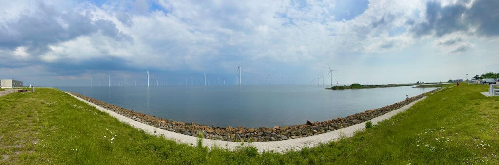
Dykes, dams and causeways have been built here, the most famous of which is the 37-km long Afsluitsdijk.
The Zuiderzee complex of dikes and dams, turns salt water from the North Sea into fresh water in the Ijsselmeer. Land is reclaimed with polders, and the bridge connects the northern and western parts of the Netherlands. A twofer – and another example of Dutch ingenuity. In fact, the American Society of Civil Engineers declared this network of protection barriers against the sea to be one of the 7 Wonders of the Modern World.
Water management along Afsluitsdijk
4. UNESCO sites in northern Netherlands – Beemster Polder
If I were to do this round in chronological order, I should probably have started with Beemster Polder. This is where the relationship between humans and water first took a serious turn – 400 years ago. We’re talking early 17th century technology.
In medieval times, this was wetlands, where the local folk were farming peat. What can you do with peat, you ask? Use it for fertiliser. Or as fuel for fire. Come the 1200s, there wasn’t much peat left. Also, water began seeping in; soon the entire area overflowed and turned into a lake. Beemster Lake, to be specific. Fast forward 400-ish years and the lake was drained, a metre-high dyke was built around it, and many, many windmills got to work pumping. Soon, this whole area was reclaimed – all 70 km2 of it. Never mind it being 3.5 metres below sea level.
As it turned out, the Beemster Polder was a success story – and other parts of the country soon followed suit. And the rest, as they say, is history. (Always wondered who ‘they’ are).
From lake to fields – 3.5 metres below sea level
Beemster Polder tourist office
In the polder is Middenbeemster, a cute little village with a cosy town square practically begging me to stop for a coffee break. To get an excellent view of the village as well as the surrounding polder, you can climb the tall tower of Keijserkerk Middenbeemster, but sadly (for me), only on Saturdays and Sundays.
Up-to-date opening hours for the tourist office is here.
Middenbeemster
Also interesting is the design here. Fields, roads and canals, all well-ordered, with straight-lined grid patterns. Classic Renaissance.
And ‘my house is my castle’ feels particularly apt here; seems every house has a moat with a bridge.
More heritage sites in northern Netherlands: it’s not all water
Here in the northern part of the Netherlands, we have been dealing solely with the country’s long history of reclaiming land. But it’s not all about water up here. In the next chapter of this road trip, we’ll talk about a fascinating social experiment from the Age of Enlightenment. And a very cool planetarium!
Stay tuned!
Schokland and Surroundings, Ir.D.F. Woudagemaal (D.F. Wouda Steam Pumping Station), Wadden See and Droogmakerij de Beemster (Beemster Polder) are all UNESCO World Heritage sites.
Here are more UNESCO World Heritage sites around the world.
UNESCO in northern Netherlands: 4 water sites is a post from Sophie’s World