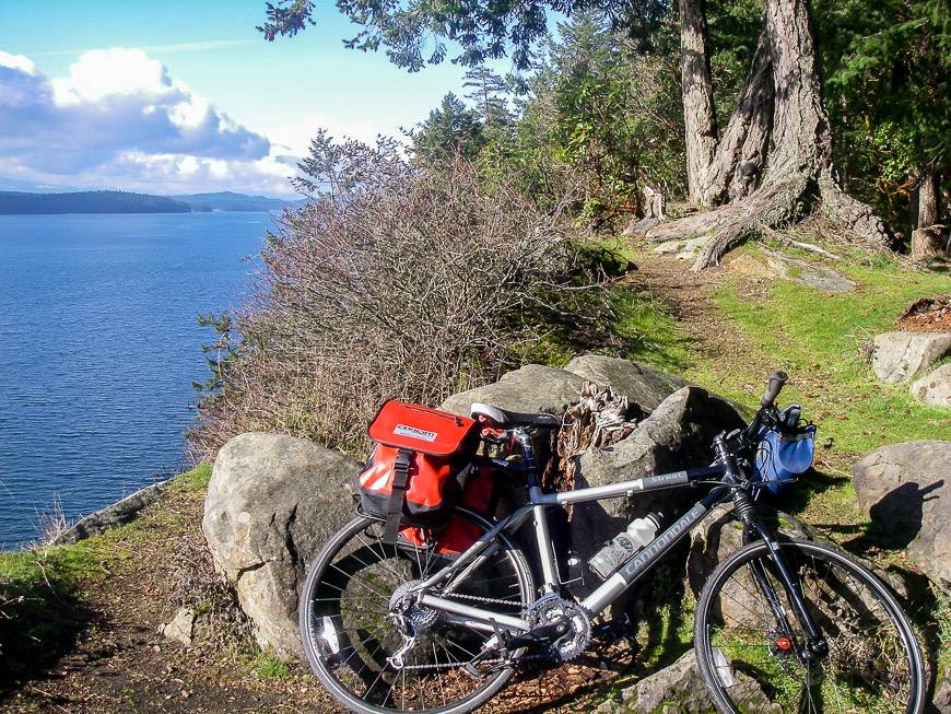
Victoria and the Gulf Islands are known for their mild temperatures, sunny days, and low rainfall, especially in the summer. Cycling the Gulf Islands in British Columbia on dedicated bike paths on Vancouver Island and generally quiet side roads in the Gulf Islands provide visitors with a fun way of actively enjoying the pastoral countryside. Frequent ocean views and the drama of the mainland mountains can be appreciated by all.
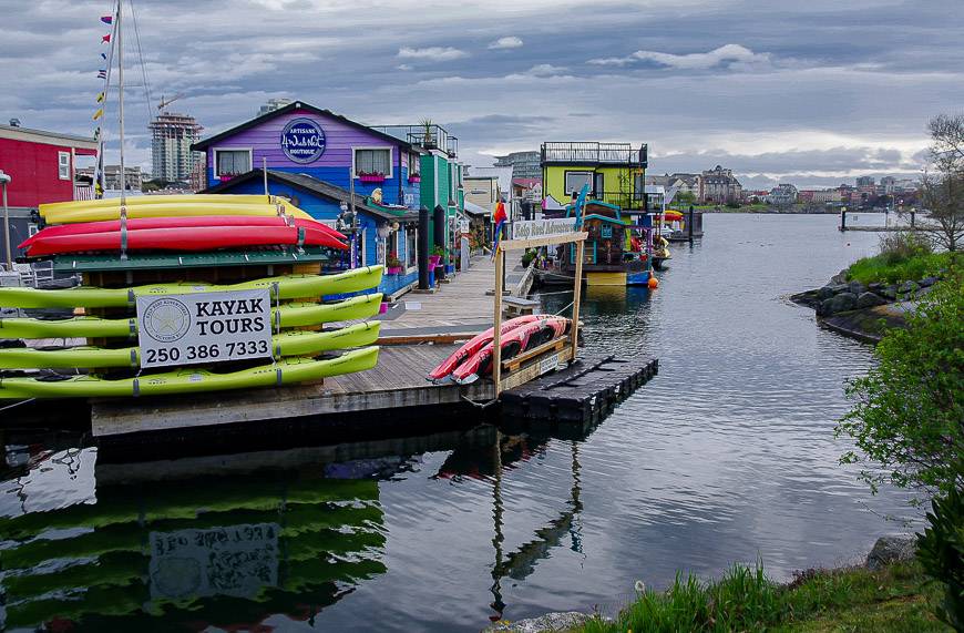
Off the bike there are plenty of diversions including visiting artist’s studios, wine tasting, farmers markets, and spas, dining and enjoying picnics on one of the small beaches easily accessed by bike. In addition, you could rent a kayak for a half or full day and perhaps enjoy close-up encounters with whales, seals, sea lions, bald eagles, and seabirds. There are opportunities to go on dedicated whale watching trips which is a fun thing to do no matter what your age.
While cycling the Gulf Islands, enjoy a wide range of accommodation options across all price points. There are intimate B&B’s, boutique inns, five-star hotels, resorts, campgrounds, and rental properties. Some islands like Saturna have very limited choices but Salt Spring Island has all options.
Plan your own cycling the Gulf Islands tour
This itinerary will provide you with all that you need to know to plan your own trip but assumes a start in Victoria. Of course, you can begin cycling the Gulf Islands tour on any of the islands if you are coming from Vancouver’s Tsawwassen ferry terminal, but if you are a visitor from outside the BC mainland – and you are flying to Victoria then that will be the obvious starting point. Plan on a minimum of 4 days (without visiting all the islands) though if you have a relaxed schedule the trip could easily be 10-day trip.
Cycling the Gulf Islands – suggested itinerary
Day 1 – Arrive Victoria and spend the rest of the day exploring the city at leisure.
Day 2 – Explore Victoria taking advantage of whale watchin and sightseeing opportunities. Pick up a bike or have it delivered at the end of the day.
Day 3 – Victoria to Saturna Island – Cycle the Lochside Trail, with the option of a side trip to visit the Butchart Gardens and Church and State Vineyards if you’re a wine lover. Catch the ferry from Swartz Bay to Saturna Island. Cycle to your accommodation for the night.
Day 4 – Saturna Island to Mayne Island – Cycle to East Point and have a picnic or if you are feeling VERY energetic head to the Sage Hayward Vineyards after the East Point jaunt. Catch a late afternoon ferry to Mayne Island. Cycle to Mayne Island Resort.
Day 5 – Mayne Island to Galiano Island – Cycle around Mayne Island taking time to visit the Japanese garden and the Lighthouse Park at Georgina Point. Catch a late afternoon ferry to Galiano Island. If you stay at the Galiano Oceanfront Inn and Spa you need only cycle a minute to arrive at your accommodation. Another option is to cycle 6 km to Sticks & Stones Cottage.
Day 6 – Spend the day on Galiano Island. If you enjoy hiking, then an early morning ride to the Bluffs might be in order. It’s about a 5 km uphill cycle and then a very pleasant, easy ridge walk with great views. People with more energy to burn could go that much further and then hike up Mount Galiano. After breakfast head to Montague Harbour and rent a kayak or organize a guided tour for half a day. Galiano is a particularly lovely island from the water. Enjoy the rest of the afternoon in the spa, relaxing or visiting one of the galleries. Enjoy a second night on Galiano Island.
Day 7 – Galiano Island to Pender Island – Catch the morning ferry to Pender Island arriving. Cycle to Hope Bay and enjoy a picturesque lunch by the water. In the afternoon cycle to Poets Cove Resort & Spa on South Pender Island. A spa service or a pleasant drink on the water may be just the thing before dinner and the night at this luxurious resort. Another option is the Shangri-La Oceanfront vacation home.
Day 8 – Pender Island to Salt Spring Island – After breakfast cycle to North Pender Island. Consider a stop at Sea Star Vineyards. Return to the ferry terminal in time to catch the ferry to Long Harbour on Salt Spring Island. Cycle the northern part of the island before heading to Ganges and your home for the night. Hastings House Country House Hotel offers luxury though there are lots of reasonably priced options.
Day 9 – Salt Spring Island to Brentwood Bay on the Saanich Peninsula – After breakfast head south towards Fulford Harbour on the backroads to avoid the traffic. Consider a stop at Salt Spring Island Cheese before hopping on the ferry for the 35-minute ride back to Swartz Bay. Cycle the northern Saanich Peninsula on the back roads and consider a wine tasting at Deep Cove Winery. Head for either the 5-star Brentwood Bay Resort & Spa and dine in or try one of the funky local cafes. Or spend a night in Sidney at the Sidney Pier Hotel & Spa.
Day 10 – Brentwood Bay or Sidney to Victoria – Finish cycling the Gulf Island by making your way back to the Lochside Trail and into Victoria to finish your trip.
Cycling the Gulf Islands – detailed island by island itinerary
Renting a bike in Victoria
If you haven’t brought a bike with you and you’re doing a self-guided bike tour, you’ll need to rent. I travel with my own detachable rack and waterproof panniers so give that some consideration before you leave home. Many of the Gulf Islands have bike rental stores but that means that you will need to start and finish on that island which may be inconvenient. There are lots of places to rent bikes in Victoria including the following. Don’t forget you’ll need panniers, a bike rack, a lock, bike pump and repair kit and a bike helmet.
- Sports Rent BC
- Trek Bicycle Store Victoria
- Veloguide
You might also need a place to leave your surplus luggage while you are on your Gulf Islands cycling tour. Sometimes the bike store will be kind enough to store it and if not most hotels, B&B’s or wherever you stay in Victoria – if you return to them, will provide that service.
What to do in Victoria
Greater Victoria is a bustling center of about 400,000 people (2021), many of whom have come to retire because of the climate. The city itself is worth at least a full day so consider doing some of the following depending on your interest.
- Combine a trip to view the outdoor collection of totem poles in Thunderbird Park with a visit to the Royal BC Museum.
- Enjoy the sights of the Art Gallery of Greater Victoria especially the works of world renown west coast artist Emily Carr.
- Take a trip to the world famous 55-acre Butchart Gardens though you can also do this by bike on the way to the ferries.
- Walk through the 1-acre garden created by Prince and Princess Abkhazi which is a superb example of West Coast garden design.
- Enjoy a Harbour Ferry Cruise.
- Indulge in high tea at the Fairmont Empress Hotel complete with scones, preserves, jersey cream, teas, sweets, and finger sandwiches.
- Go on a whale watching tour where the probability of sighting whales, especially orcas, is high.
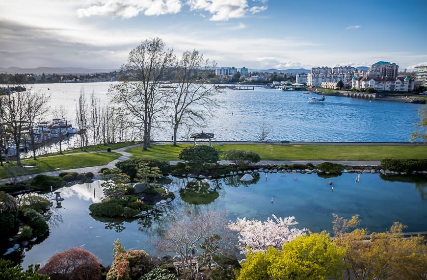
- Use the dedicated walkway along the inner harbour of Victoria. Take in the views of the floating docks and boats plus interesting old buildings. Follow your walk up with some window shopping, people watching from a cafe, gallery hopping or try a local brew at one of the local brewpubs.
Where to stay in Victoria
There is a wide range of accommodation for every budget. Certainly, a central location is helpful to see the sights and to access the start of the Galloping Goose trail. Check out some of the following.
The Inn at Laurel Point is conveniently located near the seawall and inner harbour.
Abigail’s Hotel is a 5-star boutique hotel providing a luxurious room, a gourmet breakfast and 5 pm hors d’oeuvres. It’s only 3 blocks to Victoria’s inner harbour.
Amethyst Inn is a 5-star B&B in a fully restored 1885 mansion. Prices include a full breakfast.
The 5-star Magnolia Hotel and Spa is only 4 minutes away from the inner harbour.
Cycling the Gulf Islands – plan around the BC Ferries schedule
If you are deviating from the proposed itinerary, then you will have to decide which islands you wish to visit. Spend some time looking at ferry schedules and decide which islands are most important to you to visit. You want to maximize time on the island and not on the ferry!!
If you are walking on the ferry with your bike, you will not need to make any advance reservations but they do recommend that you show up about 20-minutes before the scheduled departure. Check out the BC Ferries website for scheduled departure times. Make sure you are looking at the right month when you do your planning. Reconfirming ferry schedules as they can change suddenly with little notice, especially with employee shortages.
Cycling the Gulf Islands – Getting from Victoria to the Swartz Bay ferry
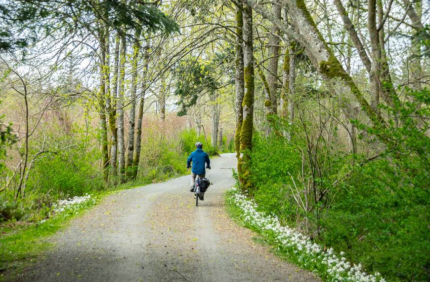
You can pick up the beginning of the Galloping Goose trail right in downtown Victoria. Access the trail after crossing the Johnston Street Bridge at the north end of the inner harbour at the intersection with Esquimalt Road. It will be well signed. After the initial 3.8 km head right at the Switch Bridge onto the Lochside Trail which will take you all the way to the ferry terminal, 29 km ahead. It is a multi-use trail so you will have to share the route at times with cars and horses. Exercise caution, especially at busy intersections. If you don’t plan on any side trips, then allow about 1.5 hours to get to the ferry.
There are several worthwhile side trips including Butchart Gardens and several wineries. The alternative is to visit them at the end of your cycling the Gulf Islands tour on the way back to Victoria.
The easiest way to access the Butchart Garden and the wineries is to follow the Lochside trail north from Victoria until you reach Sayward Road. Turn left and cross Highway 17 onto Brookleigh Road. Make a left at Oldefield, right on Brookhaven and then a right on Old West Saanich. Old West Saanich ends at Highway 17A which you will want to take until you reach the intersection of Keating Cross Road and Benvenuto Road. Turn left on Benvenuto Road and the Church and State Wines will be on your left just past the butterfly gardens.
If you continue left on Benvenuto Road after exiting the winery you will run into the Butchart Gardens shortly after crossing Wallace Drive. The gardens are open every day at 9 AM except Christmas which is unlikely to affect you. There are three restaurants on the property and lots to see but be prepared to battle with busloads of tourists in the summer.
Another winery to visit on the way back to the Lochside Trail is the small Marley Farm. When you leave Butchart Gardens look for Wallace Drive and make a left. Follow it for about 6 km to Mount Newton Pass Road and turn left. The winery is down a few hundred metres on your left. Check their schedule beforehand for tasting hours.
After your tasting, return to Mount Newton Cross Road and go right. Shortly after you cross Highway 17 you will pick up the Lochside Trail again. Head left and continue for approximately 10 km to reach the ferry. If you have time to spare, you could nip into Sidney (about 4 km before you get to the ferry) by taking Beacon Avenue. It is easy to pick up a coffee or meal at one of the many cafes and restaurants. It also boasts a huge number of very good used bookstores – in fact the highest number per capita in Canada.
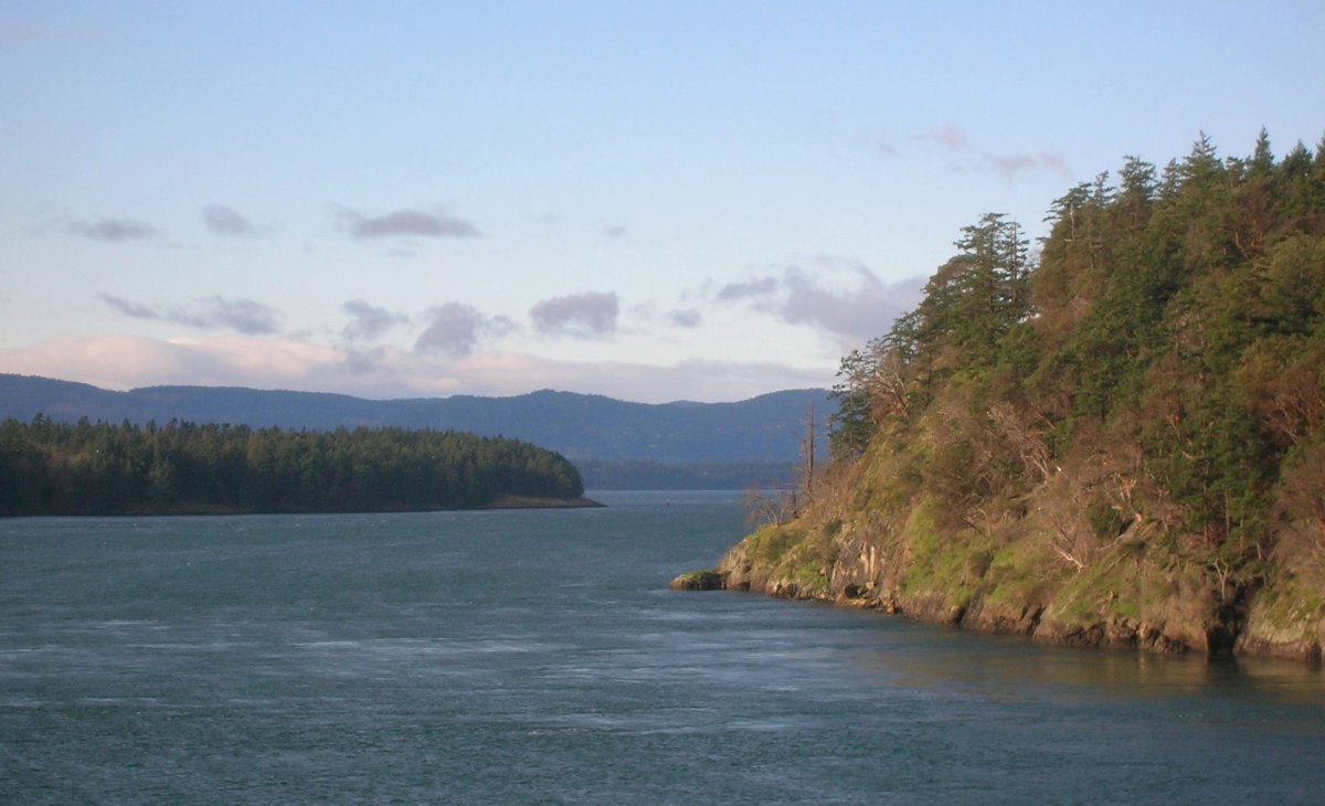
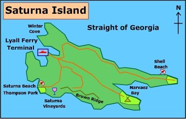
Saturna Island
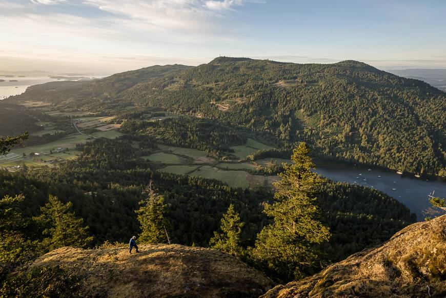
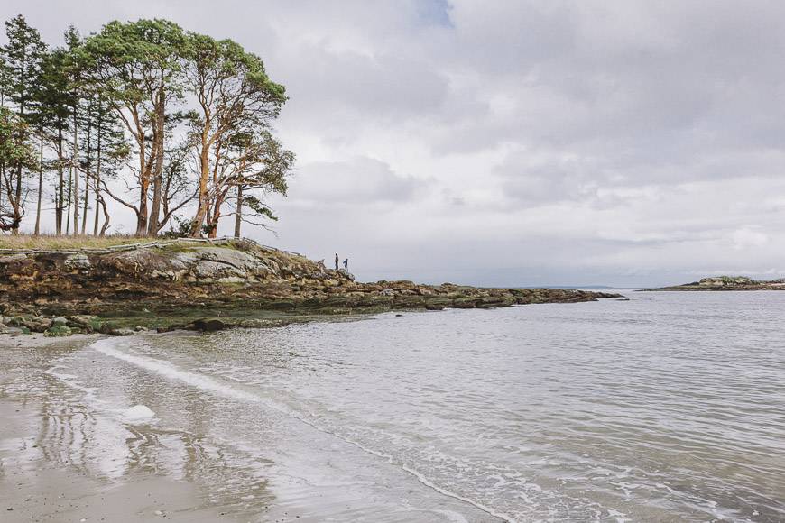
Saturna Island is the most southerly of the Gulf Islands with a decidedly rural feel to it. It is my favourite island to cycle because you are able to cycle alongside the ocean for many kilometres and at the end of East Point Road/Tumbo Channel Road (the best cycling road on the island) is a superb national park site. Beaches and well-placed picnic tables are available for enjoying the view to the San Juan Islands in Washington. The 300 or so fulltime inhabitants are a friendly lot and there are enough eateries and places to stay to warrant at least a night and more if you are inclined to hike or sea kayak.
Getting to the Lyall Harbour ferry terminal on Saturna
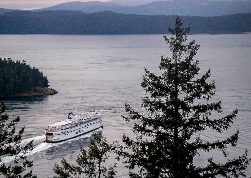
BC Ferries has scheduled non-stop service to Lyall Harbour on Saturna Island via Swartz Bay on Vancouver Island and from Mayne Island. Travelling from the other Gulf Islands will entail either a transfer or a stop so prior planning is essential. Also, the ferry schedule changes in the summer months so be sure you are dealing with the correct schedule when working out your final itinerary.
From what I have read on the BC Ferries website, there is no longer a charge for a bike. My experience is that you will always be the first to load and unload. Bikes are left near the front of the ferry, and you will be directed by a BC Ferries employee on where to put them. Fares for people vary depending on the distance travelled. There will be limited facilities on smaller ferries like the ones sailing to Saturna – think bathrooms and seating but no food or gift shops.
Note that there are no banks on the island. Most establishments accept credit and debit cards it would be prudent to bring extra cash with you as there is only one ATM at the pub in Lyall Harbour.
Cycling the Gulf Islands – Saturna Island suggested route
You won’t be able to get away from the hills on Saturna Island BUT the majority of the ride out to East Point will be flat to gently rolling.
When you get off the ferry continue up the hill on East Point Road until you come to the junction with Narvaez Road. Consider picking up picnic supplies at the Saturna General Store which you won’t be able to miss. There are no other services after this spot.
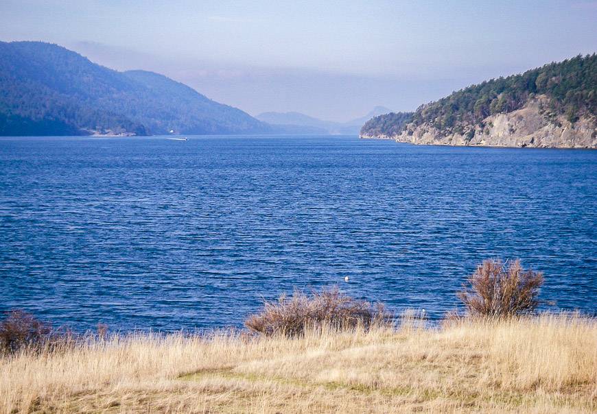
Continue on East Point Road by taking a left at the junction. After a short descent you have a rather large hill to deal with but once over that it is clear sailing until you head back from whence you came. After a total of approximately 5 km from the ferry you reach a T-junction. If you head left for just about a kilometre, you’ll reach Winter Cove which is a scenic spot and a nice place for a short break. Toilets and picnic tables are available here.
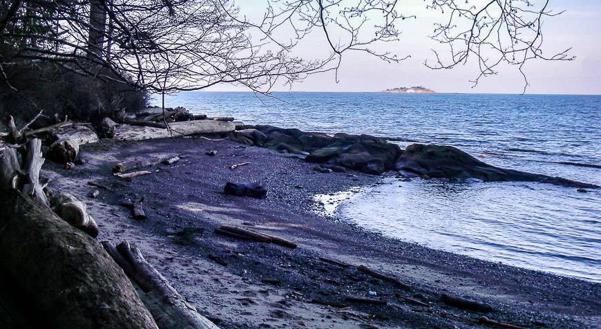
Retrace your steps to the T-Junction and continue straight along East Point Road where it eventually becomes Tumbo Channel Road, about 9 km from the T-Junction. You will find yourself riding alongside the ocean and under huge arbutus trees, a pleasant change from the heavily treed roads of the other islands. Tumbo Channel Road ends at the Gulf Islands National Park Preserve.
Lock your bike up and head out for a short meandering walk through paths of mown grasses until you get to the ocean. If you planned ahead and brought binoculars, you may be rewarded with whale sightings. Grab a picnic spot and enjoy the view. If you use your cellphones around here, beware. You may be paying for roaming charges as you could be picking up the cell tower on Orcas Island down in the US.
If you are planning to spend just the day on Saturna then you may need to keep an eye on your watch and allow enough time to retrace your route back to the ferry. A stop for a cold drink at the General Store or at the Lighthouse Pub by the ferry terminal can kill any extra time.
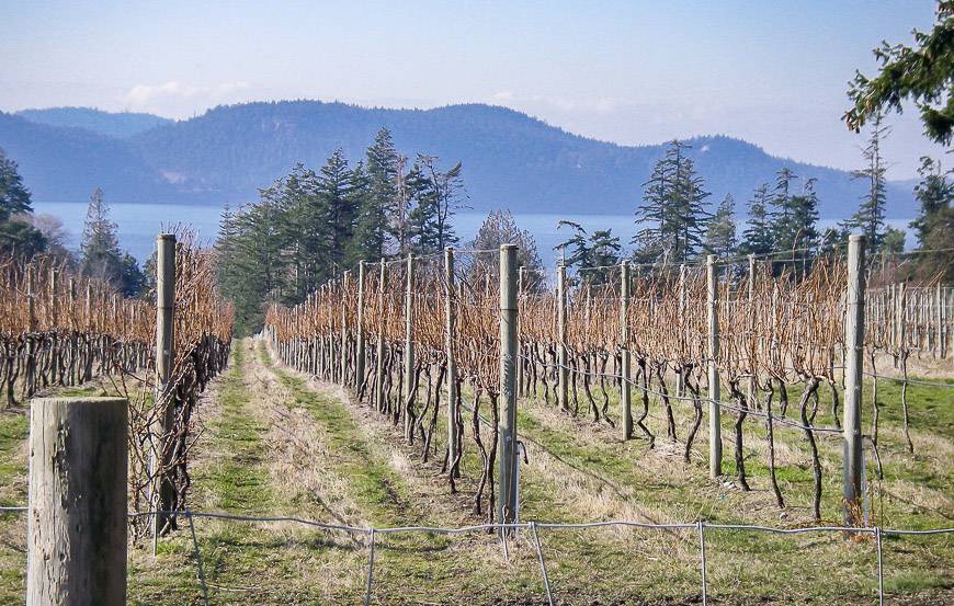
If you are feeling energetic, do the very steep ride up and down to where Saturna Island Winery used to be. Pick up the dirt road (Harris Road) directly across from the General Store. You begin climbing right away and for the first half kilometre or so you need to keep an eye out for trucks. After the truck turnoff it gets even steeper for a short distance. There is no shame in walking your bike!!! You will top out by Money Lake.
Caution: Beware of wild turkeys. One big, beautiful turkey approached me and I got off my bike to take his picture. He had me dancing around my bike using my bike as a shield to avoid being pecked. Once I finally got moving again it still had the nerve to chase me all the way up the hill. I am very glad no one was looking!!

Where to stay on Saturna
If you plan to spend the night on Saturna there is one lodge – though presently (April 2022) still closed because of COVID and several B&B’s. My recommendation would be one of these two;
Saturna Lodge at 130 Payne Road. The lodge is about a 5-minute bike ride from the ferry and well signed so you won’t miss it. It is owned and run by a friendly couple and the accommodation is comfortable and clean but not as luxurious as you might find on the other islands.
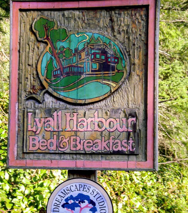
Lyall Harbour Bed & Breakfast at 121 East Point Road is another option. This B&B is just up the road from the ferry and enjoys very pretty views.
Where to eat on Saturna Island
In the off-season there is almost no choice for restaurant meals and if you plan to stay somewhere ask if they offer dinner ahead of time. At the very least from May to October these restaurants should be open.
Saturna Café at 101 Narvaez Bay Road. This small, licensed café is attached to the general store and offers indoor/outdoor dining and picnic fare. There are themed dinners on certain nights. The atmosphere is casual.
Saturna Lighthouse Pub claims to be the home of the best patio in the Gulf Islands. It is close to the Lyall Harbour ferry terminal. BC beer and wine is available plus all the usual pub food with a waterfront setting.
Other activities on Saturna Island
Saturna Island provides some lovely kayaking of the bays and channels between Boot and Winter Coves and alongside the fantastically interesting sandstone formations.
There are easy walks and hikes at East Point, Winter Cove and by Narvaez Bay. There is also a hike with a panoramic view beginning at the summit of Mount Warburton Pike. The trailhead for Brown Ridge is here and will take you to Taylor Point.
If you like poking in artists studios, you will find several to visit on the island.
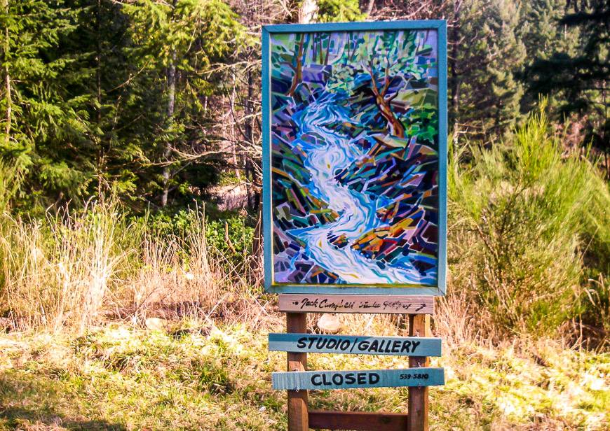
- Jack Campbell Gallery and Studio – 193 East Point Road
- Weaving by Teresa – 620 Tumbo Channel Road Ph: 250-539-2247. Shawls, scarves, rugs…
- Dreamscapes Studio
Galiano Island
Galiano Island is the first island you come to when sailing from Tsawwassen to Swartz Bay. It is the second largest Gulf Island and is home to approximately 1400 people, many of whom have an artistic bent.
I was surprised at how tough the cycling was on the island especially with a fully loaded bike. There is rarely a level section of road and unfortunately the more interesting riding is at the opposite end of the island from where the ferry berths. Fortunately, there is great hiking and there are a number of beach access points easily gained by bikes. Excellent accommodation and restaurant choices (in season) are available, and your island experience can be further enriched with studio and gallery visits, sea kayaking, and bird watching.
Getting to the Sturdies Bay ferry terminal on Galiano Island
BC Ferries has direct service to Galiano from Tsawwassen though on weekdays there are fewer sailings. Sailings from Swartz Bay are slightly more frequent though you may have to transfer or make a stop on Mayne or Pender Islands. Sailings from Mayne are nonstop but infrequent while sailings from Pender, Saturna and Long Harbour on Salt Spring Island generally require stops and/or transfers. Schedules change depending on the season, so check to make sure you are looking at the right dates.
Cycling the Gulf Islands – Galiano Island guide
Galiano is a long, narrow island with one main road running the length of the island. The biking here is more about the exercise and not the views. There are lots of beach access points accessible by bikes so a day with a picnic on a nice beach might be just the thing.
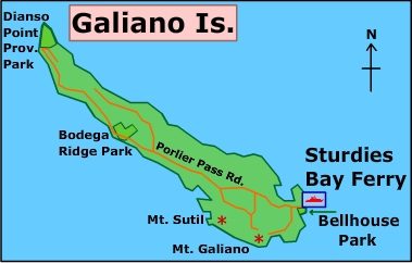
Leave the ferry and take Sturdies Pass Road to the junction of Porlier Pass and Georgeson Bay Roads at 2.5 km. Here you will find The Market – and the last spot on the road other than at Montague Harbour to pick up picnic supplies, drinks, lattes… Take a right onto Porlier Pass Road and stay on this road through to the end, about 25 km from The Market. There are lots of rolling hills and the sense at times that the forest is closing in on you. At about the 19 km mark it gets a bit more interesting as the views open to the ocean. Look out for the overlook which provides a nice spot for a break. The last 7 or 8 km provide frequent views of the ocean, but the end of the road is not much to speak of – a First Nations reserve with a NO TRESPASSING sign.
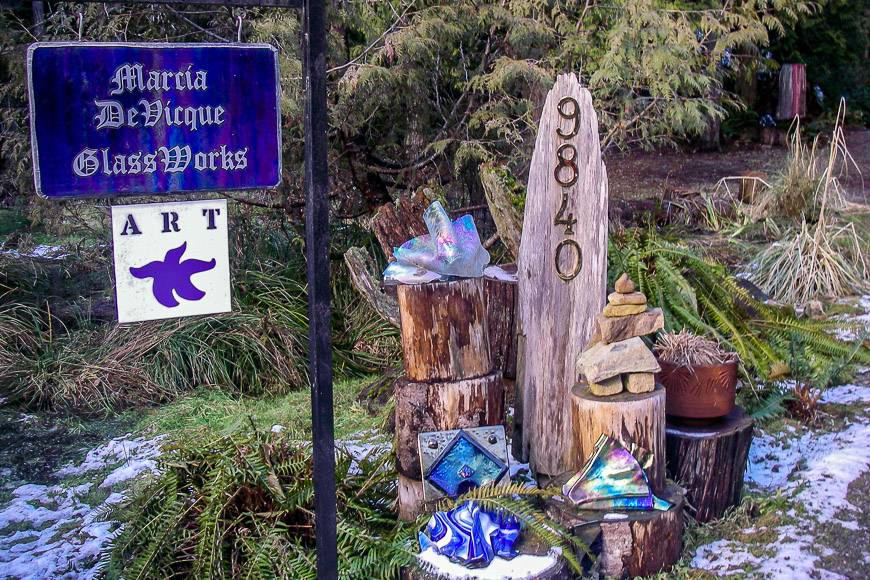
Return the same way and if you enjoy visiting artist’s studios then the hard to miss Marcia DeVicque Glass Works is very worthwhile though you will have to be creative to get one of her pieces home. In the same area is Sandra Dolph, Ceramic Artist.
Five to six kilometres after the studios is the intersection with Porlier Pass and Clanton Roads. Bear right and then the next intersection will force a choice. If you head right at the intersection onto Montague Park Road then you will end up in Montague Harbour where you can rent kayaks, mopeds, scuba dive, hike, go to the beach.
If you head left onto Montague Road that will take you back towards the commercialized part of the island and your accommodation. The complete circuit will be around 55 km. If the day described above doesn’t interest you, then consider a short bike ride to a beach for some serious lounging.
Beaches on Galiano Island
Beaches are safest for swimming on the west side of Galiano Island but the white shell beach in Montague Harbour is the most popular spot. The beaches and their access points are as follows:
- Greenwater Beach – Reach this beach by going to the end of Cain Road (near the ferry) and on the right-hand side is a short access to the beach. It is a popular one with a gentle, rocky shoreline.
- Harper Road Beach – Take Sturdies Bay Road to Porlier Pass Road and turn right on Ellis Road which also goes to the golf course. Turn right on Harper Road and go to the end of the road. The path to the beach is immediately ahead. It has lovely rocky fingers.
- Morning Beach –Just past Harper Road look for a large stone marker on the right-hand side of Ellis Road. Take the marked trail for a five-minute walk through a moss covered forest that ends at a beautiful white sand beach.
- Twiss Road Beach – This beach is accessed as above off Ellis Road. Turn right on Linklater, right on Harris and then there will be a cut-off for Twiss Road. Follow it to the end and the large, sandy beach is found just left of the driveway marked ‘The Connells.’
- Sticks Allison Beach – Follow Sturdies Bay Road to Porlier Pass Road. Turn right on Galiano Way (the next right after Ellis) and left on Sticks Allison. Continue for 0.5 km until you reach a parking area. The path to the beach is in front of the parking and will lead you down to a rock slab shelf shoreline.
Hiking on Galiano Island
There are a couple of very nice hikes on the island.
It’s a short, easy walk on top of the Bluffs with views from Active Pass to the Olympic Peninsula in Washington. To get there take Sturdies Bay Road from the ferry and make a left on Burrill. Follow it to Bluff Road (just over a kilometre) and then about 2 km along Bluff Road to the parking area for the trailhead. The last part of the road is dirt. It makes a nice bike ride too.
Mount Galiano is a short but strenuous hike that has you peaking at 341 metres (1120 feet). Once on top there is further walking if time permits. Views are great if you aren’t in the clouds. Access this hike by continuing on the Bluff Road (see above) until you reach Georgeson Bay Road. Turn left and then right on Active Pass Road and look for the signs indicating the Mt. Galiano trailhead.
Views from the Vineyard Way hike will have you looking at the Sunshine Coast all the way to Bellingham. Access is off of Bodega Bridge Drive, about 14 km down Porlier Pass Road (measured from the intersection with Sturdies Bay Road) on the right.
The 4 km Bodega Ridge hike takes only 30 minutes to get through a forested area. It will be a bit of a climb to get there but on top are outstanding views of Vancouver Island, the Strait of Georgia, and the Trincomali Channel. Access is off of Cottage Way, which is the next right after Vineyard Way, 14.5 km down from the intersection of Sturdies Bay Road and Porlier Pass Road.
Galiano Island sea kayaking
Kayaks can be rented, and tours can be booked with Gulf Island Kayaks out of Montague Harbour. There is some particularly lovely kayaking around Parker Island, Wise Island, and the Ballingall Islets and if you are more adventurous up as far as Wallace and the Secretary Islands. There should be plenty of seals, cormorants, and eagles to see. The sandstone formations along the island are very scenic too.
Where to stay on Galiano Island
Galiano Oceanfront Inn and Spa has lovely rooms with ocean views, heated bathroom floors, and nicely designed gardens to watch the birds, ferries, and wildlife.
Sticks and Stones Cottage is a self-catering option.
Where to eat on Galiano Island
There are very limited choices in the off season for dining with the Hummingbird Pub and Family Restaurant being one of the few consistent options. There is more choice on weekends but check with your accommodation ahead of time to see what they would suggest, particularly if your visit is in the late fall, winter, or early spring. Otherwise, you might be eating gas station fare.
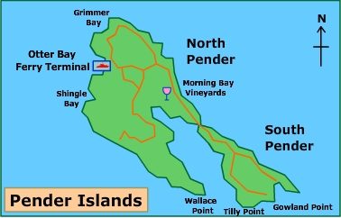
Pender Island
Pender is made up of two islands – North and South Pender that were connected at one point and were rejoined by a one lane bridge in 1956. South Pender Island is the more rural while North Pender Island houses more of the islands 2250 inhabitants and services. There are plenty of quiet back roads to explore by bike and once again no shortage of hills to deal with.
Getting to the Otter Bay ferry terminal on Pender Island
There is no direct ferry service from Tsawwassen though there are direct ferries from Swartz Bay. There is ferry service from Pender Island to Long Harbour on Salt Spring Island. Sailings from Galiano Island almost always require a short stop on Mayne Island. There are direct ferries from Pender Island to Saturna Island. The bottom line – organizing a trip to Pender Island requires some advance planning to make the most of your stay!
Cycling the Gulf Islands – Pender Island guide
There is less of a sense of the trees closing in on you on Pender Island due to more farmland, orchards, and development. There are lots of roads one could explore but this route description will get you to Hope Bay and the major commercial area on North Pender and will take you to Poets Cove and Resort on South Pender Island.
After exiting the ferry, cycle up the road until you come to the first intersection. Make a left on Otter Bay Road, less than 1 km from the ferry and head down past the golf course until you come to the intersection with Port Washington Road. That will be about 1.5 km. Go right on Port Washington and enjoy the flat quiet cycle past the antique and country store. After almost 4 km you will come to another intersection and if you head left you will quickly arrive at Hope Bay.
Hope Bay is a picturesque spot to grab some lunch. After lunch head back up the same road and take the first right for a matter of about 200 m. Then head left on Bedwell Harbour Road. Follow it and in just under 4 km you’ll reach the Driftwood Center, the main commercial area on Pender Island with grocery and liquor stores, banks, and restaurants.
From the Driftwood Center head left on Bedwell Harbour Road. It becomes Canal Road in roughly half a kilometre. Follow it along for 3 km to the one lane bridge which takes you to South Pender Island. In approximately 5 km you will reach the intersection with Spalding Road. Turn right onto Spalding and head another few kilometres to the intersection with Gowlland Point Road. Make a right and in 200 m you will arrive at Poets Cove Resort and Spa. This is a luxurious resort on the water and makes for a fine destination.
Pender Island Accommodation
There is a wide choice of accommodation including many B&B’s, vacation rentals (which generally mean longer stays and your own cooking so not as appropriate) resorts and inns.
- Poets Cove Resort & Spa
- Shangrila Waterfront Vacation Home
- Woods on Pender looks like an interesting spot to stay with Airstreams, rustic cabins and a motel.
Pender Island Restaurants
There are many restaurants to choose from though like the other Gulf Islands they have reduced openings in the off season. Weekends are always a better bet than weekdays too. Listed below are most of the available options.
- Vanilla Leaf Bakey Cafe on Bedwell Harbour Road. Offers beverages, and made from scratch baked goods.
- Hub at Hope Bay – an oceanfront space to eat, relax, & shop at Hope Bay.
- Syrens Bistro & Lounge and Aurora Restaurant at Poets Cove.
Pender Island Farmer’s Market
From May until December a farmer’s market is held on Wednesday afternoons and Saturday mornings at the Community Centre at 4418 Bedwell Harbour Road. There is an assortment of plants, baked goods, jams and organically grown produce as well as locally crafted items like soaps and some clothes.
Kayaking from Pender Island
The waters are generally calm around the Pender Islands making it a very good place for kayaking. Two-hour, three hour and full day guided tours can be arranged through Pender Island Kayak Adventures located at Port Browning Marina.
Go for a hike on Pender Island
There is a trail to the summit of Mount Norman, the highest point on the island at 244 m (800 feet) above sea level. It is accessed off Ainslie Point Road, which is an immediate right off Canal Road as you cross the bridge to South Pender Island. The walk is steep at times but still shouldn’t take longer than 30 minutes. You are rewarded at the summit with views to the Olympic Mountains in Washington.
Visit artists studios and galleries
There are numerous studios and galleries to visit around the island. A pamphlet with a map detailing all the information can be found at the Driftwood Center Chamber of Commerce information booth. Some are open daily and some by appointment only. Check out the Pender Island listing of art, theatre, and galleries.
Mayne Island
Mayne Island is located halfway between Victoria and Vancouver and as such was a resting point for hundreds or even thousands of prospectors as they rowed their way across to the mainland and the gold rush of 1858. From there it became a fashionable place in the early 1900’s to have a vacation place and that continues to this day.
It is a small island with only 1070 inhabitants but for its size it has a nice variety of services, shops, galleries, studios, and all levels of accommodation. There is a day’s worth of cycling to do and though there are hills, they’re not as large as many on the other Gulf Islands.
Getting to the Village Bay ferry terminal on Mayne Island
Bes sure to check ferry schedules before heading to Mayne Island. Count on a stop or transfer to get here. Ferries from Tsawwassen invariably stop on Galiano Island before continuing to Mayne. It takes just over 1.5 hours from Vancouver to reach Mayne Island. Ferries from Swartz Bay also have a stop on Galiano, Pender or Saturna on the way to Mayne. There are nonstop ferries between Galiano, Saturna and Pender and Mayne and some of them take only 25 minutes to make the crossing. The crossing from Long Harbour on Salt Spring Island is almost always via Pender.
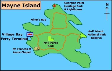
Cycling the Gulf Islands – Mayne Island guide
A cycle around the island will be a relatively easy 30 km loop. You could do it in a day and catch a late afternoon ferry to another island or take your time and spend the night so you can take advantage of the local hiking and kayaking.
After disembarking from the ferry, head left on Village Bay Road and continue until you get to the Miners Bay area just a few kilometres away. Here you can grab lunch fixings from the Sunny Mayne Bakery Cafe, visit the Mayne Island farmers market if your visit is timed to coincide with a Saturday morning between July and October or sit on the oceanside deck of the Springwater Lodge. From the decks you can watch the boat and ferry traffic and savour the view.
Continue along the water on Georgina Point Road for 3 km to the very end. Georgina Point Lighthouse and park has picnic tables so this would make a scenic lunch spot – though the reality is you really will only have done about a third of the cycling at this point! After your stop, head back a short distance until you reach Waugh Road. Make a left and follow it for 2 km until it turns into Campbell Bay Road. After another 2 km make a left onto Fernhill Road and then just before you reach Montrose on your right there will be a shopping area with interesting galleries and a great little restaurant.
If you have time you could continue along Fernhill Road and after about a kilometre it becomes Bennett Bay Road. Take it to the end and as it bends to your left you will enter the Gulf Islands National Park Reserve. Here you could leave your bikes and head for a short hike towards Campbell Point. There are excellent views and shoreline access.
Retrace your steps to the junction of Fernhill Road and Gallagher Bay Road. Make a left onto Gallagher Bay Road and then a left again in less than a kilometre onto Horton Bay Road. Steward Road off to the left will take you to another beach access point or you could continue instead on Horton Bay Road and make a right on Beechwood. There is a short hike down off of Beechwood to the shoreline and views over Plumper Sound. Plan on cycling about 4 km to reach the beach at the end of Horton Bay Road.
After you have finished admiring the views make your way back up Horton Bay Road to the intersection with Gallagher Bay Road. Go left and follow along for 1.5 km at which point the road becomes Marine Drive and then Mariners Way. A recommended side trip is a visit to the Japanese garden which is on the right as you head down Dinner Bay Road.
If you plan to head to another island, then retrace your steps along Dinner Bay Road until it reaches the junction of Dalton Road and Mariners Way. Go left onto Dalton Road and in less than 2 km you will be back at the ferry terminal and your circumnavigation will be complete.
Where to stay on Mayne Island
There is a mix of lodge rooms and B&B possibilities on the island.
Check out the Mayne Island Resort – boasting oceanfront views. Other options would include Airbnb’s or cottages.
Where to eat on Mayne Island
- Bennett Bay Bistro at Mayne Island Resort offers salads, burgers and lots of Ocean Wise seafood.
- Springwater Lodge has a great location overlooking Active Pass so there’s plenty to keep the eye busy while you munch on decent pub fare. Open for lunch and dinner.
- Sunny Mayne Bakery Cafe at 472 Village Bay Road is a great little place to pick up your latte and a pastry for breakfast and soup or pizza for lunch.
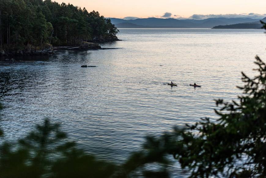
Sea Kayaking from Mayne Island
The waters around Mayne Island are more challenging than around many of the other Gulf islands. The Active Pass area is not recommended for kayaking unless you are very experienced and you time it with slack tide.
The other side of the island is a safer bet and there is plenty of poking around to do. However if I was only planning to kayak on a few of the Gulf Islands, I would not choose Mayne. Instead I would pick Galiano, Pender or Saturna for more interesting scenery and wildlife possibilities.
Hiking on Mayne Island
The only hike of substance to do is an easy hike along a woodland trail to the highest viewpoint on Mayne Island – Mount Parke. The round-trip hike needs only an hour but more if you just want to enjoy the views from the top. Access is just off of Fernhill Road, and it will be signed.
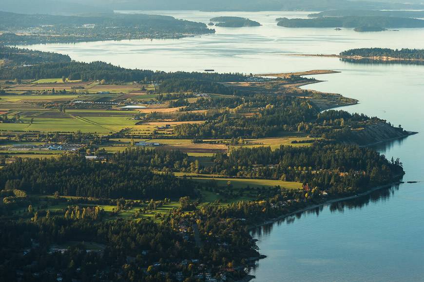
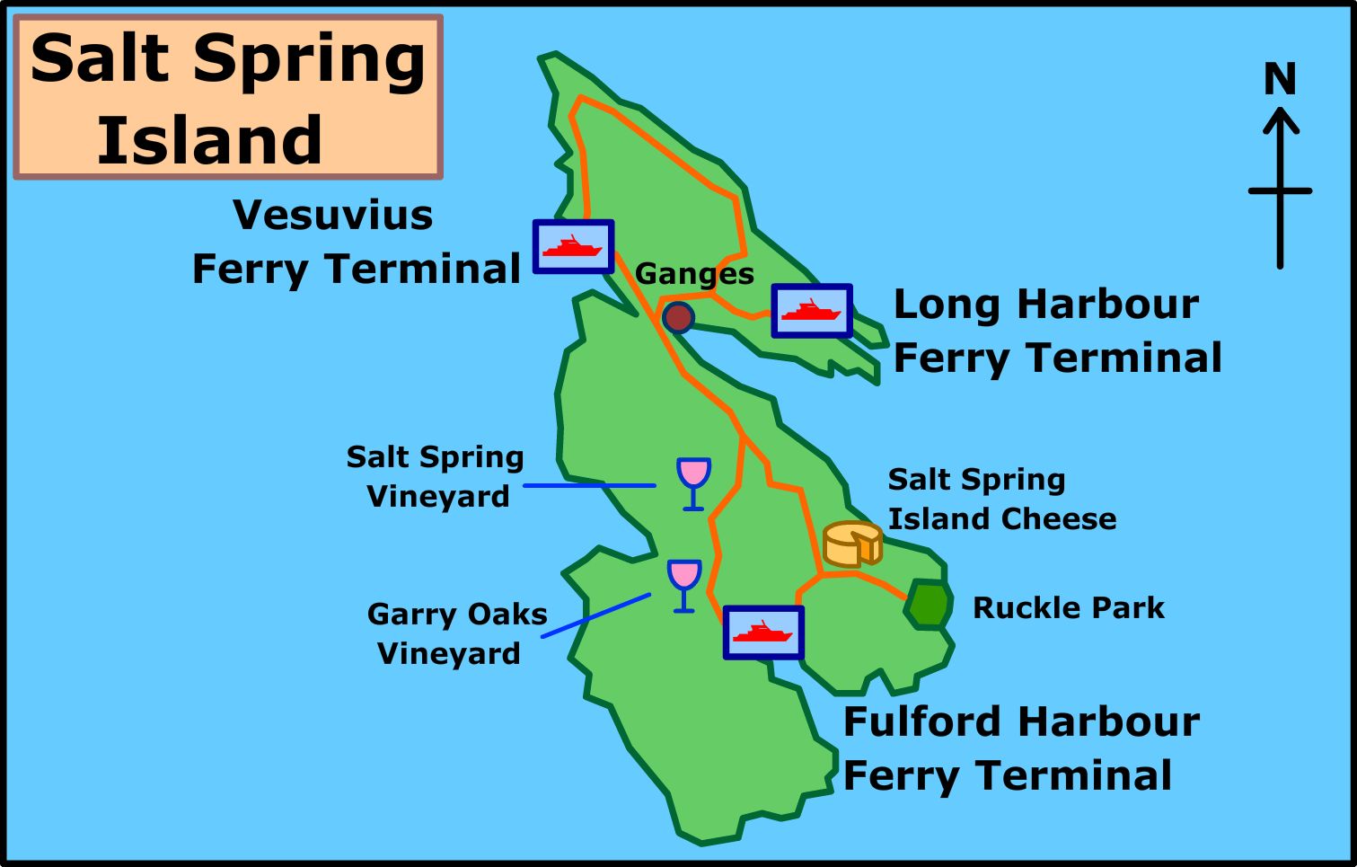
Salt Spring Island
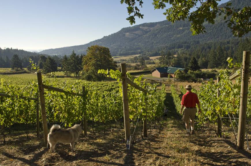
Salt Spring Island is the largest island in terms of area and population. It has a great deal to offer outside of a significant amount of very hilly biking. Many freshwater lakes provide great summer swimming and there are dozens of hiking trails ranging from easy to very strenuous. Kayaking is available at several locations around the island. There is an extensive self-guided studio tour available showcasing local artists throughout the island.
The culinary features of the island are well represented by artisanal cheese shops, wine tastings at local vineyards, numerous restaurants, and a very well attended Saturday Farmer’s market.
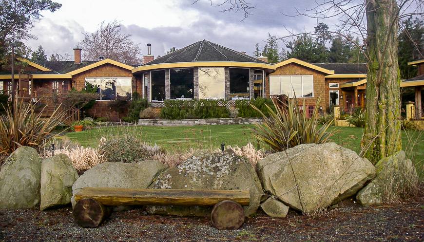
You could easily spend the better part of a week on Salt Spring depending on how much exploring you wanted to do. There is a wide range of accommodation from camping through to the very luxurious and expensive Hastings House. Two nights will give you a good sense of the island and help meet the minimum stay requirements of so many places.
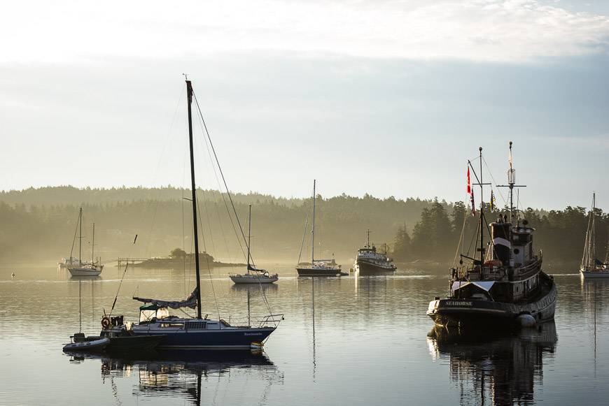
A few days can be spent exploring the island and with prior planning it is easy to leave for one of the other islands from Long Harbour. Trips back to Vancouver Island and the Cowichan Valley area are an option if you leave by way of Vesuvius.
Getting to Salt Spring Island via Fulford Harbour, Long Harbour or Vesuvius Ferry Terminals
There are three ferry terminals on Salt Spring Island which makes it a very accessible Gulf Island. Fulford Harbour is in the south with ferries coming from Swartz Bay. Vesuvius lies to the west with ferries coming from Crofton on Vancouver Island. Long Harbour is in the northeast part of the island and has ferries directly from Tsawwassen. There are multiple departures a day from Swartz Bay to Fulford Harbour, a short 35-minute sailing, so it is a very convenient entrance point. It deposits you at the main road leading to Ganges.
Cycling the Gulf Islands – Salt Spring Island
Two days of cycling the roads of Salt Spring will allow you to experience most of the island highlights. Additional days will give you the time to do more strenuous rides such as the climb of Mt. Maxwell or biking across Hope Hill to Musgrave Point. They could also permit short, leisurely rides to beaches or vineyards for wine tasting.
The suggested itinerary assumes that you will begin in Long Harbour. If that is the case you will have time to do the northern loop, spend the night in Ganges and continue on a large portion of the southern loop on the way to Fulford Harbour the next day.
A more relaxed pace will allow you to poke about artist’s studios, sample wine, picnic on the beach and generally do everything without feeling a sense of time panic. A stay in the vicinity of Ganges is the easiest thing to do, especially if this is an unsupported trip, as the proximity to restaurants and shops is very helpful at the end of the day.
The two loops could be done on either day with the major constraint being time, which ferry terminal you arrived at, which ferry terminal you plan to depart from, and which studios, wineries or shops are open to visit. There are also options to shorten the loops.
Cycling the Gulf Islands – north loop on Salt Spring Island – 30-35 km
Leave the Long Harbour ferry terminal and cycle about 4 km along gently rolling hills until you reach the main intersection with the Fulford Ganges Road. There are artists on the studio tour before you even reach the intersection so consider ahead of time what studio you might want to visit.
At the end of Long Harbour Road, you will have the option of cycling the northern loop of the island in either direction; regardless, you will be in for some short but very steep hills. If you head right at the intersection onto Robinson Road you will avoid retracing your steps.
Five to six km of hilly cycling along Robinson Road which eventually becomes Walker’s Hook Road will put you at the Fernwood Wharf. Again, there are art studios along this section of road so keep an eye out for the sheep sign indicating a studio. Across from the Fernwood Wharf the Fernwood Road Cafe provides a timely spot for a bite to eat.
Continuing along the water on what is now called North Beach Road you can enjoy about 4 km of mostly flat cycling with pretty ocean scenery off to your immediate right. At the end of North Beach Road, a climb up a short but very steep hill puts you on North End Road. If you turned left, you could cycle along St. Mary’s Lake and in roughly 9 km you would arrive in Ganges.
Instead, head right on North End Road. In less than a kilometre there is a very worthwhile side trip to visit the Blue Horse Folk Art Gallery. Take a left onto Northview, a dirt road and look for the signed studio. Their specialty is animal sculpture, beautiful horses in bronze, raku, lamps and they make and market their own dark chocolate- in case you’re hungry.
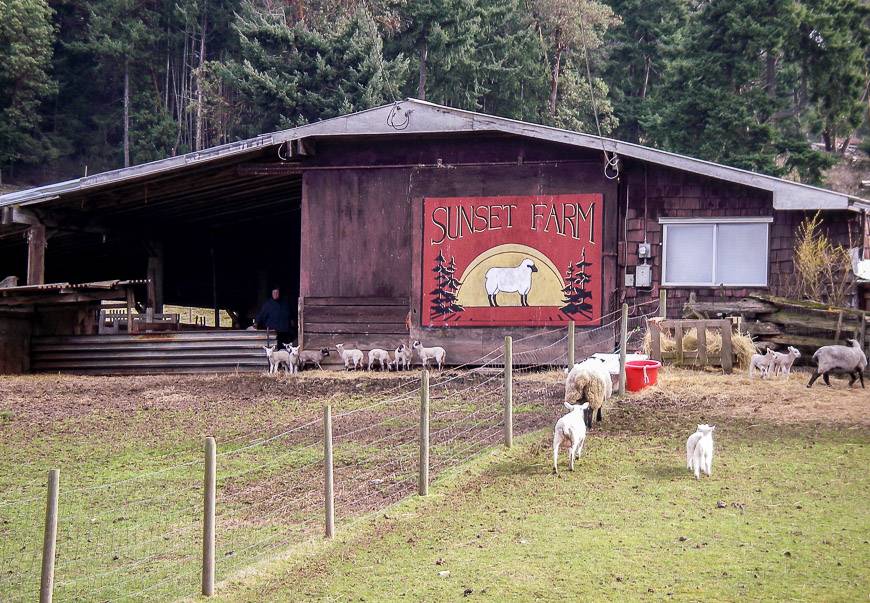
Head back to North End Road, turn left and follow it as it bends around the top of the island to become Sunset Drive. Continue up and down for about 5 km on this very hilly and narrow section of road until you reach the intersection with Vesuvius Bay Road. This is a lovely pastoral section of road and near the top of the island is the obvious Sunset Farm where you can stock up on sheepskins and lamb’s wool items. There is no shortage of baaing to be heard here either.
A worthwhile side trip if you have time to spare is to take a right off North End Road onto Southey Point Road. About a kilometre down the road at the end is a small rock beach with views of the Trincomali Channel. An even better picnic spot is the beach accessed by a 45-minute walk off Southey Point Road on Southey Point Trail (also named Jack Foster Trail). The trail is accessed within a few hundred metres of turning onto Southey Point Road on your right. On a hot summer day, it is even warm enough for swimming so pack a picnic, enjoy the view, the birds and the interesting rock formations.
When you reach the intersection with Vesuvius Bay Road, turn left to continue towards Ganges. Turning right would put you at the Vesuvius Ferry terminal and into the hamlet of Vesuvius Bay. You can buy refreshments at the Vesuvius Cafe, check out the local gallery and visit artists on the studio tour in the immediate area.
To get back to your circle tour, continue on Vesuvius Bay Road for roughly 3 km from the intersection with Sunset Drive. For a quieter cycle make a right onto Lower Ganges Road and then right again onto Canal Road. The distance from Vesuvius Bay Road is about 1.5 km. Make a left onto Rainbow Road and ride the 3 km into Ganges and your accommodation for the night.
Southern Salt Spring Island bike loop – about 50 km
Leave Ganges and begin the climb up the Fulford-Ganges Road until you reach Beddis Road, only about a kilometre away. Take a left and cycle the Beddis Road all the way to the lovely white clamshell Beddis Beach at the end, about 7 km.
To continue cycling the Gulf Islands, retrace your steps and head back up the hill until you reach Cusheon Lake Road. Turn left and then left again a few hundred metres later onto Stewart Road. A big climb will warm you up and offer distant views to the peaks on the mainland. Another few kilometres and a nice downhill will lead you to Beaver Point Road. Turn left and if you entertain ideas of a picnic lunch at Ruckle Provincial Park then make Salt Spring Island Cheese your next stop.
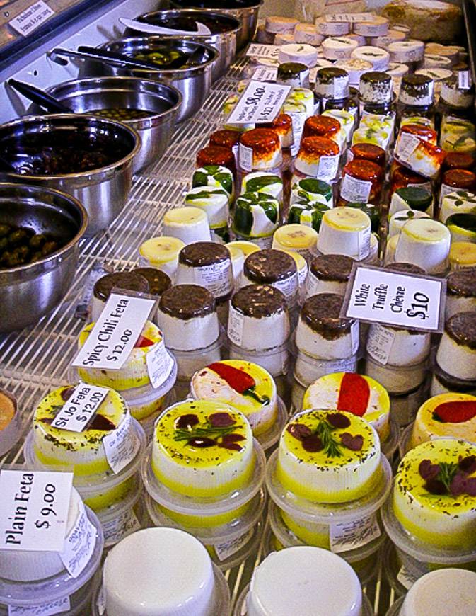
To do this take the next onto Reynolds Road and look for the sheep sign about a kilometre down the road on your left. You can park your bike and wander around the garden and farm. Well placed windows allow viewing of the operation and once inside the shop you can sample the cheeses, olives, and fruit pates.
After purchasing picnic supplies retrace your steps to the intersection with Beaver Point Road. Turn right and continue until you reach Ruckle Provincial Park, a distance of about 7 km. However, you may wish to consider one more detour if you haven’t bought bread and you’re visiting in the summer months. The Salt Spring Island Bread Co. is a popular destination for organic, artisan bread baked in a wood fired oven.
Head back to Beaver Point Road, turn right and cycle through a lovely open area that is home to a working farm. At the end of the road look for either picnic tables or head down to the rocky beach and savour the view. Ruckle Provincial Park offers 7 km of shoreline trails so after lunch you could always lock up your bike (just to be safe) and do some exploring.
To return to Ganges head back along Beaver Point Road and stay on it until it meets the Fulford-Ganges Road, about 9 km away. If you are heading for the Fulford ferry, then turn left and cycle down the road half a kilometre.
Fulford Harbour is a small hamlet with a few shops and very good cafes so even if you aren’t catching the ferry, you might enjoy a quick tour of the area. Also, in the summertime you can rent sea kayaks right on the dock by the Fulford Ferry and head out for a few hours. On a nice day this can be a good spot to watch the comings and goings of the people that make up the eclectic population that call Salt Spring Island home.
If you elect not to go to Fulford Harbour, then make a right at the intersection of Beaver Point and Fulford-Ganges Roads. This road is much busier than the ones you have cycled on so far. The shoulders are narrow so exercise extreme caution. If a ferry has just unloaded, it would be wise to let the cars pass before continuing on your way.
The upside is that the hills are gentler and there are wineries to visit on the way back. If you don’t stop at the wineries, then a straight cycle through to Ganges will add about 15 km to your odometer making the total mileage for the day in the range of 50 km.
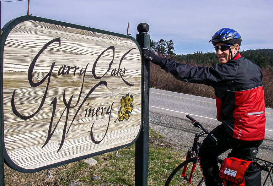
Both wineries are easily accessed 5.5 km up the road from Fulford Harbour. The first one is the Garry Oaks Estate Winery which doesn’t usually open its doors until sometime in May. Salt Spring Vineyards are a further half kilometre up the road. Try the blackberry port from Salt Spring Vineyards for something a little different!
Hop back on your bikes and in half an hour or so you should be back in Ganges…unless you have energy to burn in which case cycle 9 km up Mount Maxwell on a partially dirt road and top out at 588 m, the highest point on Salt Spring Island. The turnoff is about 2 km outside of Ganges. Take a left on Cranberry Road and follow it to the top. That should finish all but the hardiest of souls off for the day.
Where to stay on Salt Spring Island
There is one luxurious and extremely pricey inn on the island and many B&B’s running the full gamut on the quality scale. Staying close to Ganges on an unsupported bike tour will make mealtimes much easier. There are some lovely B&B’s but count on either biking to your meal or using a taxi which outside of the immediate Ganges area is an expensive alternative.
- Hastings Country House Hotel is a luxurious hotel that makes it into the book “1000 Best Places to See Before you Die”. You’ll just need the money to stay the night. Walking distance to the town of Ganges.
- Salt Spring Inn has seven rooms, some with shared bathrooms.
- Wisteria Guest House is just a short walk away from Ganges.
Salt Spring Island Restaurants
There are a host of eating choices ranging from pub type food to Chinese, Mexican, Italian, fine dining, casual dining, and everything in between.
- Barb’s Bakery & Bistro – 121 McPhillips Avenue in Ganges. Great baked goods especially their cinnamon rolls.
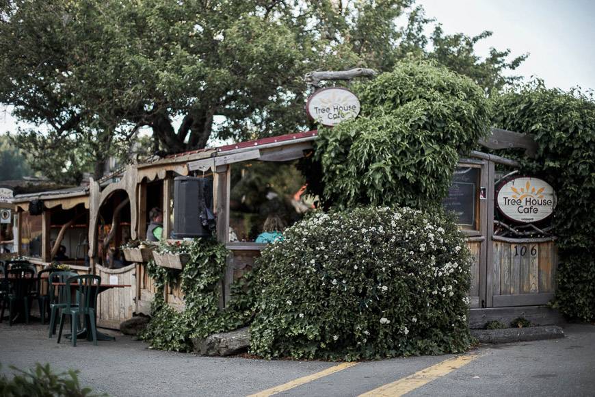
- Tree House Cafe in Ganges offers light meals outdoors under a tree. Nice ambience.
- House Piccolo in Ganges. European style menu with west coast influences. Pricier.
- Rock Salt Restaurant & Cafe – Steps from the ferry in Fulford Harbour. There is a café attached to the informal but reasonably priced restaurant.
- Salt Spring Inn – a restaurant only a few blocks from the heart of Ganges. Serves well priced pasta, pizza, burgers and seafood.
Salt Spring Island Kayaking
There are many companies offering kayak instruction and tours on an hourly, half day and full day basis.
- Salt Spring Adventures They offer tours out of Ganges Harbour as well as sunset tours, bioluminescent tours and more.
- Salt Spring Island Beachside offers half and full day tours as well as sunset tours.
Salt Spring Island Beaches
There are lots of beaches scattered around the island. Just a smattering of the better ones are included here.
- The beach at the end north end of the Jack Foster Trail is a 45-minute walk on a trail off Southey Point Road at the north end of the island. The trail takes you to a mixed gravel-sand beach with nice views of the Trincomali Channel
- Beddis Beach at the end of Beddis Road is a beautiful white crushed shell beach but swimming will be cold. It is on the east side of the island.
- Ruckle Provincial Park is at the southeast end of the island and although there isn’t any sand, the beachcombing over boulders and flat rocks is excellent.
- Fernwood Point is a great beach during the summer and is found to the left of the Government Wharf at the intersection of North Beach Road and Walker’s Hook Road in the northern part of the island. You can walk out along sandy mudflats but beware of live (which are black) sand dollars. There are great tidal pools to explore too.
Hiking on Salt Spring Island
Salt Spring Island has a huge range of hiking opportunities from easy to very strenuous and difficult. A few suggestions are included below.
- Mount Maxwell hike – About 9 km up a mostly dirt road, which is accessed off Cranberry Road, are 6 km of maintained trails including a ridge walk and a trail to Baynes Peak with splendid views. In bad weather the road can be poor.
- There is a short steep trail accessed off Collins Road to Mount Erskine. From Ganges take Rainbow Road and at the end of it head left onto Collins. Continue down Collins Road and look for a red trail marker on the left side of the road across from large arbutus trees. The trail will be signed. Outstanding views reward this strenuous hike.
- There are 7 km of shoreline trails to explore in Ruckle Provincial Park with tiny coves and rocky headlands. Interesting tide pools can keep you entertained for hours.