Most roads take you from one place to another, but some roads are journeys in their own right. The Karakoram Highway is firmly the latter – a journey of towering mountains, ancient cultures, and ever-changing horizons, winding through some of the most dramatic landscapes on Earth.
Karakoram Highway, day 1: Skardu – Gilgit
Early in the morning on the last day in June, we leave Islamabad, and board Pakistan Airways for the quick 45-minute hop to Skardu.
We are in Gilgit-Baltistan, formerly known as Pakistan’s Northern Areas – in Kashmir, a disputed region ever since the Partition of India in 1947.
Northern Pakistan is vast and geographically challenging, and we can’t realistically see everything in one trip. So where to go? Fairy Meadows… the name alone, enchanting! And K2 Base Camp sounds all kinds of awesome, if you’re into hard-core trekking. We’re not. Not really.
As much as we’d love to see it all, we must be selective, so we decide on a road trip from Skardu to Kashgar, the final 900 km of the world’s highest-altitude road, the 1300-km long Karakoram Highway.
We’re not staying in Skardu, but flying in there makes sense, as its airport is more reliable than Gilgit’s. The runway at Gilgit is only 1,648 metres long, too short for standard jetliners like Airbus A320. Only smaller planes can land there, making flights particularly susceptible to unpredictable high-altitude weather. As a result, flights are frequently cancelled.
Skardu Airport is one of the highest airports in the world and handles both civilian and military flights. Mountains as far as the eye can see here, in every direction, with the legendary K2 and Nanga Parbat less than 100 km away. Even the peaks closest to the airport rise to 4,500 – 5,000 metres, almost modest in comparison.
Skardu
But it would be a shame to miss Skardu altogether, so Saqib, our fixer, gives us a quick tour of the area.
We head to Lower Kachura, a pretty lake surrounded by the red pagoda-shaped villas of the Shangri-la Resort.
Fun fact: In the grounds by the lake is a Douglas DC-3 that once belonged to Orient Airways. On 13 October 1954, three minutes after taking off from Skardu, the engine failed and the pilot made an emergency landing on the riverbed close by. Everyone survived, and the plane was abandoned. 29 years later, the resort’s founder bought the fuselage from the airline and had it brought here. Today, it’s a cafe.
A short ride away is Upper Kachura Lake, larger, deeper and wilder. To get there, you have to climb down about 100 steep, sometimes slippery, steps. Descending is a bit challenging for me, since I have a torn hamstring (and yes, I’ll probably mention that again ). Luckily, going back up is easier.
Upper Kachura Lake
Down at the lake are orchards – cherries, apricots, apples, pears, walnuts – as well as boats for rent. Would have been lovely bopping about on the glacial water. But we have places to go and must be on our way. Also, Saqib promises more lakes, more mountains, more boats, and more orchards.
On the road
We leave Skardu behind and set out on the long road to Kashgar. I’m excited! Eight years ago, we spent a week driving along the Pamir Highway. This journey promises to be just as thrilling.
The stretch from Skardu to Gilgit is harsh and beautiful in equal measure: barren cliffs, deep gorges and the Indus River carving its way through the mountains. For much of the way, I simply stare out the window, humbled by the scale of the landscape around me.
Gilgit
Gilgit is shaped by a long and fascinating history. In ancient times, it served as an important crossroads on the Silk Road, and later a strategic outpost during the so-called Great Game. Even later, it was a flashpoint in modern-day military conflicts. Still is.
In fact, the Wakhan Corridor in Afghanistan was created as a buffer zone to prevent the British Empire (now Pakistan/India) and the Russian Empire (now Tajikistan/Central Asia) from directly touching.
For us, the city is a welcome pause after a long drive. We’re staying overnight in this mountain town where travellers, traders and locals have crossed paths for centuries.
No time to waste, so we throw down our bags, and head out for a look at Gilgit.
Gora Qabristan: the old British graveyard
At the old British Graveyard in the centre of Gilgit, you can see remnants of that quarrelsome history. The little cemetery is the final resting place for British military personnel, political agents, and foreign explorers. The first to be buried here was Lt. George Hayward. He was murdered in July 1870, whilst exploring the Pamir Mountains. Dramatic history allround!
The Aga Khan Shahi Polo Ground
Near the graveyard, is the Shahi Polo Ground.
Polo is the national sport of Gilgit-Baltistan. The games here don’t seem to follow international rules, though: no referees, no time-outs. It’s a bit more free-style – fast, aggressive, and with a good dose of passion, more similar to Central Asian kok-buru. The biggest difference is that whilst those players fight over a heavy goat carcass with their bare hands and upper-body strength, polo players chase a small, wooden ball and hit it with long mallets.
Danyor Suspension Bridge
The narrow, wooden Danyor Bridge spans the roaring Gilgit River. It’s the first of several suspension bridges we’ll encounter along the route – and, as it turns out, the least wiggly of them. A cool thing about it, is that it goes directly into an ancient tunnel carved directly through solid rock.
As evening falls, I feel the anticipation of the days ahead. The real heart of the Karakoram Highway still lies before us.
Karakoram Highway, day 2: Gilgit – Hunza Valley
Before setting off towards the Hunza Valley, Gilgit deserves further exploration.
Heli Chowk
In a public square in Gilgit, is a vintage Indian Army helicopter on a pedestal. Shortly after the Indo-Pakistani War of 1971, it crossed the LoC (military speak for ‘Line of Control’) and entered Pakistani airspace. The Pakistan Army forced it to land, took it into custody, and arrested the pilots. They were treated as POWs and interrogated – standard protocol – and later repatriated through a diplomatic prisoner exchange.
Kargah Buddha: Buddha Rock
About 10km west of Gilgit, at the mouth of a ravine, is a 1400-year-old Buddha, carved into solid granite, 10 metres above ground. Back in the 7th century CE, Gilgit was a key stopover for Buddhist monks travelling the Silk Road.
This looks like a Buddha relief to me, but local folklore has another story. According to local Shina legend, the figure is a terrifying woman called Yachani, who ate men and terrorised the valley. The villagers summoned Daiyal Khimito – a holy man – who caught Yachani, pinned her to the cliffside and turned her to stone. ‘When I die,’ he said to the villagers, ‘bury my body here, and she will never come to life again.’ But now the villagers worried: what if he goes off and dies and we can’t find him? So they killed poor Khimito and buried him. No good deed goes unpunished.
Mighty Rakaposhi
Back on the road, we continue into the Hunza Valley, and the scenery begins to change.
The valley opens dramatically, revealing terraced villages, orchards filled with apricot and walnut trees, and snow-covered peaks in every direction.
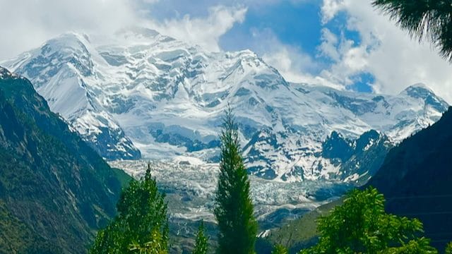
First stop: Rakaposhi – and what a sight she is!
At 7,788 metres, Rakaposhi is imposing from any side.
Rakaposhi is the only mountain on earth that plummets directly, uninterrupted, from almost 6,000 metres to its broad base, which stretches almost 20 kilometres from east to west. The snow-covered peak rises spectacularly above the valley, framed by steep green slopes and trees. Far below, the Hunza River winds through the valley, fed by glaciers and mountain streams.
Me, I’m mountain-struck. Again. The Matterhorn was first, that ‘now you see me, now you don’t’ hiding behind clouds. And now I’m completely enthralled by Rakaposhi. It’s magnificent, and entirely indifferent to my presence. I sit and stare at her for ages, whilst sipping locally grown cherry juice and not even noticing the seeds before I nearly choke on one.
Hunza, at last
At last, we are in the Hunza Valley!
The Hunza River once marked the border between two independent, fiercely competitive, mountain kingdoms: Hunza and Nagar.
Once there were two kingdoms, one on either side of the river
About 30 years ago, I read Travels, Michael Crichton’s memoir. The Jurassic Park author travelled through this region in the 1970s, back when they were in a sort of in-between state, integrated into Pakistan, but not quite, still functioning as autonomous monarchies.
Legend had it people in this area were exceptionally happy and healthy and lived long lives, and MC was here to see if it were true. Could Hunza be the inspiration for the fabled Shangri-La?
Sadly no, it turned out. No miraculous health or utopian longevity. MC left disillusioned. Also, tourism and modernity had ruined the place, he thought. Bit arrogant, I think.
Ever since, the name Hunza has lingered in my mind, sparking a decades-long wish to see it for myself. And now, I’m finally here!
No longer separate kingdoms, but one united region
Four nights in Karimabad
We are staying in Karimabad, capital of the former Hunza Kingdom. Four nights will give us something often missing from a road trip: time. Time to stop chasing the next destination, wake up without packing, and allowing the valley to reveal itself in its own way.
Baltit Fort
We arrive late afternoon and go to Baltit Fort right away; it closes at 17.00.
Karimabad is built on a steep slope directly beneath the 7,399-metre Ultar Peak, and Baltit Fort is at the base of the massif. The road up is 1 kilometre long, and steep. Very steep. But dammit, I’m going to see that fort, so I limp along, way behind the others. The road is very scenic, and full of little shops and cafes.
The fort has been the seat of the mirs – the kings of Hunza – for 700 years and is on UNESCO’s tentative list. Walking through the wooden rooms and balconies, I imagine the generations of rulers, traders and travellers who have looked out at these same mountains.
Inside are low-ceilinged corridors and narrow doorways, built that way to force potential intruders to bow down. Must have been turbulent times back then.
Baltit Fort sat abandoned and decaying for decades, but was restored at the end of the 20th century, along with Karimabad, by the Aga Khan Trust for Culture (AKTC), and financed in large parts by the Norwegian government.
Going back down, we wander through Karimabad’s narrow lanes, passing stone houses and small shops selling handicrafts, dried fruit, and suspicious-looking, foul-smelling health remedies. Every turn offers another view over the Hunza River and the immense mountains beyond.
We have dinner at the legendary Hunza Food Pavilion, run by Lal Shehzadi, known as Hunza’s superwoman. Lal serves organic regional specialties like chap shuro (meat-stuffed flatbreads) and daudo (noodle soup).
A bit further down the road is Yak Bar.
We visit this cosy place several times and try every drink on the menu.
Karakoram Highway, day 3: Lake Attabad, Hoper Glacier, Eagle’s Nest
North in the valley, the Karakoram Highway cuts past dramatic cliffs and villages towards Lake Attabad, where brilliant turquoise water fills a landscape shaped by a massive, relatively recent landslide.
The lake is a hub for high-energy adventures – you can go speedboating, jet-skiing, kayaking, zip-lining, or take a scenic trek into the surrounding mountains. In winter, the water freezes into a huge, natural skating rink.
Try the zip-lining, perhaps? Saqib advises waiting for Hussaini Bridge.
The Hoper Glacier is next. We’re now over in the former Kingdom of Nagar, by one of the most accessible glaciers in the Karakoram range. You can enjoy the view with a cup of tea from a cliffside terrace at the edge of the village or get a broader perspective from the lateral moraine viewpoint, a 15-minute uphill walk.
If you’re up for it, you can descend to the active ice sheet. It takes roughly 20-30 minutes to scramble down, though longer to get back up, as the moraine wall is steep with loose rocks and gravel.
In the evening, we go for the short climb to Eagle’s Nest to watch the sun set over the wall of giants – Golden Peak, Ultar, Diran, Ladyfinger, and Rakaposhi – all 7,000+ metre peaks – waiting for the evening light to colour them in shades of pink and gold.
Here are Andrew’s snaps from Eagle’s Nest.
Me, well, I get about halfway up, to this plateau…
…before I slide and rip another tear in my hamstring. OK, that might be over-dramatising slightly, but I definitely do something that makes me want to scream. It hurts so bad tears explode from my eyes.
To bed with an ice pack!
Karakoram Highway, day 4: Day of rest
My leg is making it clear today should be a rest day. So whilst the others are out exploring, I’m doing the sensible thing for once: taking it easy on the balcony, scribbling away.
Karakoram Highway, day 5: Ganish, petroglyphs, and Altit Fort
Leg is all better, so today I get to catch up on what Tom and Andrew explored yesterday. They’re kind enough to come along again and keep me company.
First, we step into Ganish, a 1,000-year-old Silk Road fortress. We wander narrow, vehicle-free alleys lined with mud-and-stone houses and ancient mosques uniquely carved with Islamic, Buddhist, and Hindu motifs.
The most striking feature is a large, historic water tank turned public pool, where children splash against a backdrop of ancient timber walls.
Alongside the road near Ganish, is an open-air archive known as Haldeikish – the Sacred Rocks of Hunza. A massive, 180-metre-long smooth rock wall is covered in prehistoric petroglyphs and ancient inscriptions left behind by merchants, pilgrims, and soldiers between the 1st and 6th centuries CE.
The surface is etched with lively drawings of ibex alongside historical graffiti carved in ancient languages like Sogdian, Kharoshti, Brahmi, Chinese, and Tibetan. It’s a profound reminder of the diverse global crossroad we’re travelling through.
Next, we make our way to Altit Fort, which sits spectacularly on a sheer cliff edge overlooking the roaring Hunza River. Altit is the oldest surviving monument in all of Gilgit-Baltistan, and has stood watch over the valley for more than 1,100 years. From here, the Mirs ruled the valley before moving to Baltit Fort three centuries later.
Like Baltit, this fort has also been restored (by AKTC and Norway) and is practically a living museum, surrounded by the ancient, winding paths of Altit Village below, and a royal apricot orchard.
As in Ganish, the heart of the village features a massive water tank, originally excavated to harvest soil to build the fort all those centuries ago. Now, it’s a sprawling pool where kids escape the summer heat. In winter, it transforms into an ice hockey rink.
Juice stop at this cool little place in Altit Village
Back in Karimabad, we try Cafe de Hunza’s famous walnut cake.
We’ve been meaning to all week.
For the rest of the afternoon, we chat and write postcards, then one final stop at Yak Bar.
Here in the fading daylight, I realise that Hunza has done what the best places do: it has made me slow down. Well, Hunza – and a wonky leg.
The mountains are spectacular, but it’s the quiet moments I’ll remember: the cherry juice, the smell of apricot wood smoke, the evening light on a distant glacier.
Karakoram Highway, day 6: Karimabad to Sost
Today, we head back to Upper Hunza. The scenery becomes ever more open and remote.
Gulmit village
Our first stop is Gulmit, once the summer capital of the Kingdom of Hunza. 1 km above town is the 16th-century Ondra Fort; Pakistan’s highest and longest stairs gets you there.
We enjoy the peaceful, traditional pace of life here among the Wakhi people, whose Central Asian roots shine through in their language, music, and welcoming culture. Would have loved to stay a few days here in Haseema’s house.
Hussaini suspension bridge
And then, the promised Hussaini suspension bridge, stretching nearly 200m across the Hunza River, and proper wobbly, unlike the one in Gilgit. I go a quarter of the way, maybe less – then turn back.
The rest of the gang cross to the other side, then zip-line back. It looks loads of fun, but I’ve watched the guys on the platform tug your leg hard to slow you down. Not risking it.
The Passu Cones and yak burgers
The Passu Cones are a row of sharply pointed, jagged peaks rising dramatically above the Hunza Valley, many of them over 7,000 metres high. Behind are even higher mountains, with the Passu Glacier tucked amongst them. It’s a striking combination of rock, snow and ice that seems almost too perfectly arranged to be real. It’s hard to stop staring at them.
Nearby, is the open-air Yak Grill, serving organic yak burgers with a view.
Not really a burger gal myself, but I’m told the yak burgers are well worth trying.
Sost, and China beyond, are drawing closer, but we still have a few stops to make in the mesmerising Hunza Valley.
Yet another suspension bridge, rainbow-painted, swings across the Hunza River near the Batura Glacier, adding a splash of colour to the rugged landscape.
Just beyond, the valley softens into cherry orchards. Even in this stark mountain landscape, there are pockets of lush, fertile land.
It’s hard to say goodbye to Hunza, but the road beckons.
Next up: onwards to the Khunjerab Pass and the Chinese border. And heaps of flamboyantly decorated lorries.
Sneak preview:
All photos by Andrew Morland, Tom Brothwell and myself.
A journey along the Karakoram Highway, part I: Skardu to the Hunza Valley is a post from Sophie’s World