Europe is home to some of the world’s best hiking, from hut-to-hut treks through the Alps and long-distance coastal paths to spectacular mountain day hikes and warm-weather trails in the Mediterranean. I’ve been lucky enough to hike many of them.
This list of European hikes isn’t pulled together from guidebooks or other people’s recommendations. Every trail and destination featured here is somewhere I’ve personally hiked. I’ve completed some long-distance trails from end to end, while on others I’ve spent several days hiking the best or least difficult sections – the Alta Via 2 being a good example. I’ve also included a few destinations like Ireland where I’ve hiked multiple trails like the Kerry Way and Dingle Way, which I tackled as back-to-back trips.
Below you’ll find my suggestions for the best hiking trails in Europe, organized into long-distance treks, day hikes in the mountains, and warm-weather hiking destinations. For each one, I’ve included the information I find most useful when planning a trip. That includes distance, difficulty, hiking time, accommodation, luggage transfers, and my honest take on what makes the hike worthwhile.
If you’re looking for a European hiking adventure where you can walk for several days without carrying camping gear, tackle a challenging mountain route, or escape to somewhere warmer in winter, you’ll find lots of ideas here.
Europe’s Best Trekking Trails I’ve Personally Walked
These are the European long-distance trails I’ve personally walked, including several I completed from end to end and others where I hiked the best sections.
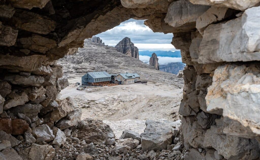
Looking at Rifugio Boe on the Alta Via 2 from a rock formation above the hut
Hiking Trails in Europe At a Glance
Hiking trailCountryDistanceDaysDifficultyBest forTour du Mont BlancFrance/Italy/Switzerland170 km8-11HardAlpine sceneryAlta Via 2Italy187 km11-14DemandingHigh mountainsKungsledenSweden103 km6-7Easy–ModerateArctic wildernessDingle WayIreland179 km8-9ModerateCoast and villagesKerry WayIreland203 km8-10DifficultMountains and coastFishermen’s TrailPortugal226 km11-13ModerateCoastal walkingPembrokeshire Coast PathWales299 km14HardDramatic coastline
How to Choose the Best European Hiking Trail for You
My process for choosing the best European hiking trail usually starts one or two years out. I get a bee in my proverbial bonnet and decide I want to finally hike a trail I’ve heard about for years – cue the Pembrokeshire Coast Path in June 2026. Or I decide I want to visit a new country or tackle a hard trail before I can’t, like the Alta Via 2 that I did last year in Italy.
Right now I’m focused on some warm weather hiking for next spring, so I am seriously looking at hiking in Malta and Crete for a week in late March and early April. Next summer, I’d like to hike parts of the GR34 along the coast of Brittany and do either the Peak of the Balkans route or some of the best day hikes in Picos de Europa. The bottom line – I never lack for ideas, just time.
Looking for spectacular mountains?
→ Alta Via 2 / Tour du Mont Blanc
Want a long-distance hike without camping?
→ Dingle Way / Kerry Way / Fishermen’s Trail / Pembrokeshire Coast Path
Prefer solitude?
→ Pembrokeshire Coast Path
Interested in hiking above the Arctic Circle?
→ Kungsleden Trail
Looking for warm weather?
→ Mallorca / Canary Islands / Lycian Way
Want a first European multi-day trek?
→ Dingle Way / Fishermen’s Trail
Interested in a serious physical challenge?
→ Alta Via 2 / Tour du Mont Blanc / Pembrokeshire Coast Path
Dry mountains as a backdrop on Gran Canaria
Iconic Long-Distance Hiking Trails in Europe
I’ve completed some of these trails in their entirety and hiked substantial sections of others; I’ve made that clear in each description.
Tour du Mont Blanc (France/Italy/Switzerland)
Distance: 170 km (206 miles) loop
Elevation gain/loss: Approximately 10,000 m (32,800 feet)
Time needed: 8 – 11 days depending on speed and additional side trips
Difficulty: Hard because of the daily distances and elevation gain and loss
Highest point: Grand Col Ferret at 2,532 m (8,307 feet) on the standard route; Col des Fours or Fenêtre d’Arpette which are both at 2,665 m (8,743 feet) but on more challenging route options
Best time to hike: Early September; mid-July to mid-August is peak time; possibility of running into snow in late June and early July
Accommodation: Hotels, mountain refuges/huts
Luggage transfers: Yes via Taxi Mont-Blanc or Mountain Drop-offs
Guide needed? No, but inexperienced hikers might appreciate one
My take: The Tour du Mont Blanc hike in France, Italy and Switzerland is one of the world’s classic long-distance walks and an absolute must if you love hiking. The scenery is fabulous, the huts are welcoming and there is lots of choice in how you handle the daily distances.
The Tour du Mont Blanc in Italy
Alta Via 2 (Dolomites, Italy)
Distance: 187 km (116 miles)
Elevation gain: + 10,547 m (34,603 feet)/ -11,450 m (37,566 feet)
Time needed: 11 – 14 days for the whole trail – we stopped at the Rosetta Hut after 8 days
Difficulty: Demanding – with a head for heights
Highest point: 2,907 m (9,537 feet) at L’Antersas near Rifugio Boè
Best time to hike: Third week of June to the third week of September
Accommodation: Mountain rifugios and hotels or hostels in towns
Luggage transfers: Yes, but only when booked through an outfitter offering the service; luggage transfers are available only to towns, not rifugios.
Guide needed? No, but you can go guided – which is a good option if you are nervous about doing the trip on your own
My take: The Alta Via 2 trek in the Dolomites is one of the most magnificent multi-day hikes I have ever done in the world. It was challenging – more mentally than physically because of all the exposure, though I was always happy to see the hut at the end of the day. The mountain scenery is absolutely mind-bogglingly beautiful on some days.
I’m looking across an wondering how gnarly the day is going to be on the Alta Via 2
Kungsleden Trail (Sweden)
Distance: 103 km / 64 miles
Elevation gain: Approximately 2,000 m / 6,562 feet
Time needed: 6-7 days
Difficulty: Easy to moderate depending on daily distances
Highest point: Tjäkta Pass at 1150 m/ 3,770 feet
Best time to hike: July to early September
Accommodation: STF huts, camping, or both
Luggage transfers: No
Guide needed? Usually not as it’s straightforward
My take: The most popular 103-kilometre section of the Kungsleden Trail in Sweden lies above the Arctic Circle and deserves a spot on your bucket list. The awe-inspiring landscape is a beautiful mix of lakes, rivers, birch forests, open fells, wetlands and mountains – and it’s particularly spectacular in fall when the landscape bursts with colour.
Spectacular scenery on the Kungsleden Trail after you pass through the narrow section
Dingle Way (Ireland)
Distance: ~179 km/ 112 miles
Elevation gain: +2,590 m (8,497 feet)
Time needed: 8-9 days
Difficulty: Moderate
Highest point: On the slopes of Masatiompan Mountain at 660m (near Mount Brandon)
Best time to hike: Between April and September
Accommodation: B&Bs, hotels, and camping at official spots
Luggage transfers: Available
Guide needed? No – as it is well-marked
My take: The Dingle Way is one of Ireland’s premier long-distance walking paths, combining some of the country’s best scenery with a rich archaeological story. The trail showcases peaceful farmland, wild ocean vistas, clifftops, and open peatlands in addition to beautiful coastal scenery. It is usually close to civilization, and almost half of the walk is on tarmac – the only downside to the hike.
Good signage along the Dingle Way in Ireland
Kerry Way (Ireland)
Distance: ~203 km (122 miles)
Elevation gain: Approximately 5300 m
Time needed: 8 – 10 days
Difficulty: Hard
Highest point: Windy Gap (Lack Road) at 385 m
Best time to hike: Between May and September
Accommodation: B&Bs, hotels, and limited camping
Luggage transfers: Available
Guide needed? No
My take: I hiked the Kerry Way by myself and enjoyed the landscape immensely. Highlights for me included walking through beautiful Killarney Park, the gorgeous though desolate landscape between Black Valley and Glencar, isolated valleys, wild moorlands, some spectacular coastal scenery, views across the Beara Peninsula, and the pretty small towns of Kenmare, Sneem, and Cahirciveen. I also took a day off so I could visit the Skellig Islands – which was a highlight of my three weeks in Ireland.
Meeting a cow on the Kerry Way in Ireland
Fishermen’s Trail (Portugal)
Distance: 226 km (140 miles)
Elevation gain: Mostly flat to rolling trail on top of sea cliffs and sand dunes approximately 30 to 70 m above the Atlantic Ocean but count on occasional short steep climbs
Time needed: 11 – 13 days
Difficulty: Moderate – mainly because of the long distances and occasional airy cliff sections
Highest point: The southern coastal plateau near Vila do Bispo is about 159 m/522 feet above sea level
Best time to hike: March to May and September and October
Accommodation: Guesthouses, hostels, hotels
Luggage transfers: Yes – readily available
Guide needed? No. This is a well-marked trail.
My take: The Fishermen’s Trail in Portugal is one of the premier multi-day hikes in Europe. It follows ancient fisherman’s paths, primarily along the coast and through a host of beautiful Portuguese fishing villages with little development until you reach the Lagos area. It’s a wonderful spring hike with wildflowers and comfortable hiking temperatures.
Incredible scenery heading north on the Fishermen’s Trail on the way to Vila Nova de Milfontes
Pembrokeshire Coast Path (Wales)
Distance: 299 km/ 186 miles
Elevation gain: ~ 9,780 m/ 32,085 feet
Time needed: 14 days
Difficulty: Hard because of long distances, elevation gain, and airy sections
Highest point: 574 feet (175 m) at Pen Yr Afr on Cemaes Head
Best time to hike: April to September
Accommodation: B&Bs, hotels, camping
Luggage transfers: Yes
Guide needed? Not required
My take: The Pembrokeshire Coast Path in Wales is one of the top long-distance walks in Britain. It follows a spectacular coastline from Amroth to St Dogmaels over 299 km. Look forward to dramatic sea cliffs, white-sand beaches, wildflowers, seabirds, colourful seaside villages and character-filled harbours, along with a few historic castles and numerous ancient forts. It does, however, have many airy sections which may be challenging for some people, especially if it is windy or rainy.
Solva to St. Justinians on the Pembrokeshire Coast Trail
Lycian Way, Turkey: Ancient Trails and Mediterranean Coastline
The Lycian Way is one of Turkey’s classic long-distance hiking routes, combining rugged Mediterranean coastline, mountain scenery, ancient ruins, and small villages. I haven’t hiked the entire route, but the sections I’ve completed gave me a good taste of what makes this trail so special. Although it’s really in Asia, most tour companies lump it in with Europe and I’ve done the same.
Distance: 500+ km for the full route
Elevation gain: 24,000 – 25,000 m
Time needed: Several weeks for the complete route
Difficulty: Hard with daily elevation gain and loss of 700 – 1000 metres
Highest point: Mount Tahtalı (Olympos) at ~2,366 m
Best time to hike: March to May and September to November
Accommodation: Guesthouses, pensions, small hotels, and camping
Luggage transfers: On short sections only
Guide needed? Usually not because the trail is well-marked with red-and-white waymarkers
My take: While I only spent five days hiking the Lycian Way, I can honestly say I was completely enchanted with the landscapes, the people, and all the delicious food. It was tougher going than expected with serious elevation gain and loss every day – but then just when you were parched and needed a break, seemingly out of nowhere there would be a small stand selling freshly squeezed pomegranate juice.
Hiking close to Mount Olympus on the Lycian Way
Big Mountain Day Hikes in Europe
Europe is blessed with many mountain ranges – and for that reason there are a huge number of amazing day hikes – from peaks above the Arctic Circle in Norway to alpine routes in the Dolomites, Alps, and Carpathian Mountains. Enjoy this sampling of day hikes I’ve done.
Lofoten Islands, Norway: Europe’s Most Spectacular Day Hikes
The Lofoten Islands in Norway offer some of the most dramatic day hikes in Europe – with stupendous views of the Arctic Ocean, white-sand beaches, and colourful fishing villages. Instagram has put the Lofoten Islands on the wish list of most hikers – and after spending a week hiking in the Lofotens, I can tell you that every hike I did exceeded all expectations. Whether you’re looking for a half-day hike or a full day mountain adventure, you will find it in these gorgeous islands above the Arctic Circle.
The amazing view of Reine from Reinebringen hike
Reinebringen Hike (Lofoten Islands)
Distance: 2.2 km /1.4 miles return + a walk from the parking lot
Elevation gain: 448 m/1,470 feet
Time needed: 1.5 – 3.5 hours round-trip depending on your level of fitness and how much time you spend on top
Difficulty: Easy if you hike a lot and moderate if you don’t. The trail feels airy in places.
Why it’s worth hiking: The steep Reinebringen hike takes place on 1,978 steps – carefully built and laid by the Sherpas. The views from the top of Reine and the coastline are outstanding.
You sure get a workout on the Rheinbrigen hike
Munkebu Hut Hike (Lofoten Islands)
Distance: 10 km return
Elevation gain: ~ 410 m/ 1,345 feet for Munkebu Hut and 797 m/ 2,615 feet for Munken
Time needed: 2 – 3 hours one way to Munkebu Hut + 50 – 70 minutes one way to the top of Munken. We spent about 6 hours hiking in total but allow up to 7.5 hours return for both
Difficulty: Moderate
Why it’s worth hiking: The Munkebu Hut hike is one of the very best hikes in the Lofoten Islands. The hike has an alpine feel with dazzling blue lakes, rugged mountain terrain and expansive views in every direction. The fact that you can combine it with a climb up Munken only adds to the allure. And by Lofoten standards, this is not a busy hike.
Munkebu Hut beside the lake on Moskenesøy
Ryten Hike + Kvalvika Beach (Lofoten Islands)
Distance: 12.5 km return
Elevation gain: 930 m/3,051 feet
Time needed: 5 – 7 hours
Difficulty: Moderate if you’re a regular hiker
Why it’s worth hiking: The Ryten hike – Kvalvika Beach combination rewards with dramatic cliffside views over one of the most stunning beaches in the Arctic. Add in the hike down to Kvalvika Beach and back up to increase the wow factor. This white sand beach looks like it belongs in the Caribbean but it’s above the Arctic Circle. It’s a hike you don’t want to miss if you’re visiting the Lofoten Islands – but pick a sunny day for the best experience.
The view of Kvalvika Beach from Ryten
High Tatras, Slovakia: Alpine Day Hikes in the Heart of Europe
The compact High Tatras mountain range extends across Slovakia and Poland and forms the highest part of the Carpathian Mountains. Some of the best day hiking in Central Europe is here. You’ll find jagged peaks, stunning alpine lakes, mountain huts, and pretty valleys.
The three hikes described below showcase the range of hikes available – including a challenging summit climb to the top of Poland, in addition to a beautiful lake and waterfall hike.
Hiking Rysy from Slovakia to Reach the Top of Poland
Distance: ~21 km (13 miles) return from Štrbské pleso
Elevation gain: 1,370 m (4,495 feet)
Time needed: 8 – 10 hours return
Difficulty: Hard because of the elevation gain and distance
Why it’s worth hiking: It’s always a very cool thing to hike to the top of a country – and by hiking Rysy from Slovakia you can stand on the top of Poland at 2,499 m. The hike starts near Štrbské Pleso in Slovakia’s High Tatras mountains and climbs past alpine lakes and a mountain hut before reaching the summit on the Slovak-Polish border. The only downside I found was the sheer number of people hiking – but that may have been because it was a Polish holiday.
We were not alone hiking Rysy from Slovakia
Zelene Pleso Hike: A Stunning Trail to Green Lake in Slovakia’s High Tatras
Distance: Approximately a 20 km loop
Elevation gain: 365 m (1,198 feet) and a loss of 1,200 m (3,937 feet)
Time needed: 6 – 8 hours
Difficulty: Hard
Why it’s worth hiking: The Zelene Pleso hike in Slovakia’s High Tatras is a spectacular day hike featuring a gondola ride, a hike up Velka Svištovka peak, and a very steep descent – with chains to reach stunning Zelené Pleso (Green Lake), an impossibly green lake surrounded by rugged peaks. Enjoy lunch here before continuing the descent back to town.
Beautiful Zelené Pleso (Green Lake) in Slovakia’s High Tatras Mountains
Waterfall Skok Hike in Slovakia’s High Tatras
Distance: Approximately 11.4 km return
Elevation gain: 442 m/ 1,450 feet
Time needed: 2.5 – 3 hours + 1.5 hours to do a return trip to the lake above the waterfall
Difficulty: Easy to the waterfall, moderate if you climb the chains above the Skok Waterfall
Why it’s worth hiking: The Waterfall Skok hike is a great way to get a taste of the High Tatras mountains when you only have half a day. The waterfalls are pretty – but what I really like is the view above the waterfalls from the chain section. And if you have the time, it would be easy to use Waterfall Skok as the starting point of a fabulous all-day hike to a magnificent cobalt-blue lake.
Waterfall Skok is a popular half day hike
Warm-Weather Hiking Destinations in Europe and Beyond
I live in western Canada near Calgary and winter lasts a long time here – with snow starting most years in early November and leaving sometime in April. As much as I love winter, I also enjoy a break from it – and am always on the lookout for European destinations that meet my criteria for interesting hiking with generally sunny weather. I don’t need it to be hot – in the low 20’s°C is fine by me. Two places that are particularly good for winter hikes are the Canary Islands and the island of Mallorca off the coast of Spain.
Mallorca: Hiking the GR221 Through the Serra de Tramuntana
Mallorca, one of Spain’s Balearic Islands in the western Mediterranean Sea, is a tremendous warm-weather hiking destination in winter. Here you’ll find the GR221, also called the Dry Stone Route. It crosses the Serra de Tramuntana Mountains via ancient stone paths, wildly terraced hillsides, mountain villages, coastal views, and Mediterranean landscapes of olive groves and almond trees.
While you can hike the full GR221 over 7-10 days, you can also do some spectacular day hikes on individual sections – which is exactly what I did.
Es Capdella to Estellencs: A Rugged Introduction to the GR221
Distance: 14 km
Elevation gain: 670 m/2198 feet
Time needed: 5 – 6 hours
Difficulty: Moderate
Description: The hike from Es Capdella to Estellencs is one of the best sections on the GR221 in Mallorca. This section takes you from country lanes past a Finca to rocky hills covered in grasses. Spectacular Mediterranean Sea views are the reward on the descent into town.
Some wildflowers are blooming in late March on the hike from Es Capdella to Estellencs
Valldemossa to Sóller: The Most Scenic Section of the GR221 in Mallorca
Distance: 24 km / 14.9 miles
Elevation gain: 1,200 m / 3,937 ft
Time needed: About 8 hours
Difficulty: Hard to challenging
Description: The most rewarding section of the GR221 is the full day spent hiking from Valldemossa to Sóller. This tough trail offers panoramic mountain views of the sea, fragrant olive groves, and charming stops like Deià and Can Prohom. It’s a must-do for any hiker exploring the Serra de Tramuntana.
Beautiful descent on the GR221 in Mallorca
Hiking in Mallorca: From Sóller to Alaró via the GR221
Distance: 17 km
Elevation gain: 55 m
Time needed: About 5.5 – 6 hours
Difficulty: Moderate
Description: We opted for an abbreviated hike from Soller to Alaro with a drop-off at the Cúber Reservoir to save 13 km of hiking. Highlights of the day included beautiful views of the Gorg Blau Reservoir, gorgeous white mountains, Tossals Verds Refugi at lunch, and an atmospheric old estate that produced olive oil.
Good signage on the Soller to Alaro hike
Canary Islands: Volcanic Landscapes and Excellent Winter Hiking
If you need a warm-weather hiking destination in winter, check out the Canary Islands. I know some places like Tenerife have been complaining about too many tourists – but that’s in the city and not in the quiet countryside.
The Canary Islands are a grand place to go hiking. Every island has a different vibe – but all feature volcanic landscapes, dramatic coastlines, and interesting and varied terrain. Plus a lot of potatoes on the menu!
We had two weeks and chose to split our time between two very different Canary Islands: a week hiking on La Gomera, a quiet island known for its lush forests, rugged coastline, and spectacular scenery followed by a week hiking on Gran Canaria. Over seven days of hiking on Gran Canaria, we experienced an impressive variety of landscapes, although surprisingly little coastal walking. The trails took us from high volcanic ridges and pine forests to deep barrancos and quiet mountain villages.
Descent from Punta Alcala on La Gomera
Me admiring the views from Artenara – a cave village on Gran Canaria
Final Thoughts on Hiking in Europe
I am lucky to have a lot of world-class hikes in the Canadian Rockies practically on my doorstep. But that doesn’t stop the itch to explore more of the world, preferably on a multi-day hike. I love the variety and sheer number of trails and countries to visit in Europe. While I have done many of the classic European hikes, I don’t need a famous trail to visit – just one that looks interesting in a country I’d love to see more of.
Near the end of the Kungsleden Trail – one of my all time favourite treks in Europe
More Great Hikes, Treks & Backpacking Trips
Hiking the Stunning Via Alpina in Switzerland – A spectacular multi-day route linking alpine villages, high passes, and jaw-dropping mountain scenery across the heart of the Swiss Alps.
10 of the Most Scenic Backpacking Trips in Canada – A nationwide roundup of Canada’s most scenic backpacking trips, highlighting diverse landscapes from coastal routes to alpine and boreal wilderness.
35 Top Day Hikes in Canada – Personally Tested – A curated list of standout day hikes across Canada, all personally hiked, ranging from coastal trails to alpine routes.
Best Hikes near Kanab, Utah – A guide to some of southern Utah’s most striking hikes, featuring slot canyons, sandstone formations, and dramatic desert landscapes.
Top 17 Best Hikes in Arizona – From iconic canyon trails to lesser-known desert gems, this roundup highlights Arizona’s most rewarding hikes across the state.
Click on the photo to bookmark to your Pinterest boards.
The post Best Hiking Trails and Routes in Europe: Personally Tested Day Hikes and Treks appeared first on Hike Bike Travel.