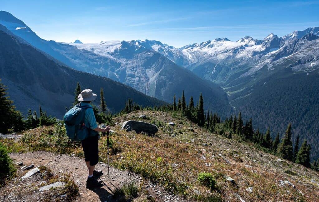
The Avalanche Crest Trail is one of the most scenic and spectacular hikes in Glacier National Park, BC. It’s a hard, steep non-technical climb through beautiful old-growth forest and sub-alpine meadows to reach an open basin. One final steep climb from the basin to the end of the trail rewards you with incredible views of glaciers, rugged mountain peaks, and the Trans-Canada Highway far below.
The name Avalanche Crest is fitting. From November through May, numerous avalanches start on the slopes of the crest, with some of them reaching the highway. That’s not a big surprise considering that 10 to 14 metres of snow falls each year at Rogers Pass – but it is a reminder of why the slopes are treeless – and of the power of these avalanches.
The 10.2-km return hike gains 795 m over 5.1 km, so there’s no escaping a steep climb, especially during the second half of the hike. But if you’re comfortable with a prolonged uphill hike, the scenery more than makes up for the effort. I was blown away by the mountain and glacier views at the top. Should you be looking for more dramatic mountain scenery, the Glacier Crest Trail climbs onto a rocky ridge between the Illecillewaet and Asulkan valleys, while Abbott Ridge delivers another spectacular high-elevation viewpoint.
This post includes affiliate links. If you make a qualifying purchase through one of these links, I may earn a small commission at no extra cost to you. Thank you for supporting my website.
Stellar views from the Avalanche Crest Trail of the Asulkan Valley
Avalanche Crest Trail at a Glance
Please take personal responsibility for your safety by researching conditions, preparing appropriately, and making informed decisions.
Distance: 10.2 km return
Elevation gain: 795 m (2,608 feet)
Difficulty: Hard
Time needed: 5 – 6 hours
Type of hike: Out and back
Trailhead: Just up from the Illecillewaet Campground (near Rogers Pass)
Best season: Mid to late July through to September (depends on snowpack)
Dogs: Permitted on leash
Bears: Know how to stay safe in bear country. Carry quick to access bear spray and make noise, especially in thick vegetation. Bear bangers are not permitted in the national parks.
What a backdrop for our lunch at the top of the Avalanche Crest Trail (looking west towards Revelstoke)
Map of the Avalanche Crest Trail
Note the start near of the Avalanche Crest Trail (#13) near the A. O. Wheeler Hut.
Topo map showing the Avalanche Crest Trail (#13)
What Makes the Avalanche Crest Trail Special
I’ve done five other hikes in Glacier National Park, four of which stand out for their spectacular glacier and mountain views: the Hermit Trail, Glacier Crest Trail, Abbott Ridge, and Asulkan Valley and Hut. The Avalanche Crest Trail joins this group of first-class hikes thanks to the superlative 360-degree views from the top of the ridge.
Glaciers and mountains are everywhere you look. Should you lower your gaze to the valley floor, 2,000 metres below, you’ll see the Trans-Canada Highway heading west towards Revelstoke and more mountain peaks in the distance.
A glorious feeling of hiking among glaciers and mountains on the Avalanche Crest Trail
Avalanche Crest Trail Hiking Route
The road to the Illecillewaet Campground and trailhead for all the hikes from here is accessed off the Trans-Canada Highway. If you’re heading east, there is an obvious signed turnoff. But if you’re heading west, you must continue for about 1.5 km to use a marked U-turn route. You’ll need to be in the far left lane to make the turn. After you’ve made the U-turn, you can get back on the Trans-Canada Highway heading east – and look for the signs for the Illecillewaet Campground.
Avalanche Crest Trailhead and Parking
The Avalanche Crest Trail starts near the Illecillewaet Campground in Glacier National Park, about 45 minutes east of Revelstoke and about an hour west of Golden, depending on traffic and construction.
When I hiked the trail in late August 2026, I found two parking lots just past the turnoffs into the Illecillewaet Campground. Drive up as far as you can – and if you’re early enough you should be able to park in the parking lot closest to the trailhead. There is another one just down from it – and if that is full you can try to park along the road. There is also a parking area shortly after turning off the Trans-Canada Highway – but that would add almost a kilometre at the start and end of the day. Try for the closer parking lots first.
From the parking lot head up the dirt road to an intersection. Go straight (if you went left you’d reach the Arthur O. Wheeler Hut in about a minute and if you went right, you’d cross a bridge over the Illecillewaet River within 150 m.) Just one minute up the trail go left at the sign to stay on the Avalanche Crest Trail.
Hiking to the Avalanche Crest
The first part of the trail climbs up past large western red cedar and western hemlock trees as it switchbacks, climbing about 500 m over 2.7 km to reach a stream and crystal-clear pond. It’s pretty, mostly open hiking.
After the pond, the trail narrows and the vegetation thickens. That’s when we started making noise – just in case there were any bears around. The kilometre-long section through the forest was the least interesting part of the hike, but it was also where we had to pay the most attention to our footing. Don’t rush it.
Once you’re out of the forest, the trail climbs for about half a kilometre through wildflower-filled sub-alpine meadows to reach a basin. There is an obvious trail heading up the basin – likely used by climbers en route to climb Avalanche Mountain.
When you reach the basin there is a small, ground-level sign beside a trail with an arrow pointing to a viewpoint. Head up the trail to the crest – and admire the view down to the valley where you can see the Trans-Canada Highway. As tempting as it may be to stop here, don’t.
Continue on the well-used trail climbing steeply for several hundred metres to reach an “End of the Trail” sign. The signed end of the trail is a natural turnaround point for hikers. Beyond it, the route becomes rougher and more technical, so only continue if you have the appropriate experience and skills.
This was where we stopped to have lunch and revel in the views. You get good views of Mount Sir Donald, which looks remarkably like the Matterhorn, the route up to the Asulkan Hut, the Asulkan Glacier, the mountain peaks on the north side of the Trans-Canada Highway along with the glacier east of the Hermit Trail. You can also see distant peaks to the west.
After lunch we ran into several groups of people on their way up. In total – on a picture-perfect summer day, we saw about 10 people.
The descent went faster than I thought it would and we were down in 2.5 hours – after a stop to refresh our feet in the cold stream by the pond. It was a perfect day in the mountains.
You quickly reach the intersection of the Avalanche Crest Trail with the one going to Perly Rock and Mount Sir Douglas
Massive western hemlock trees near the beginning of the hike to Avalanche Crest
An easier grade on the Avalanche Crest Trail early on the hike
Views towards the Asulkan Valley Trail and Asulkan Glacier from the Avalanche Crest Trail
We’ve almost reached the basin just below Avalanche Crest; Avalanche Mountain with some snow is right of centre
Follow this trail to the top and turn right
End of trail sign on the Avalanche Crest – and our lunch spot and turn around point
Descending the short trail that leads up to the top of the Avalanche Crest Trail
The Best Views on Avalanche Crest
There are amazing views in all directions once you reach the end of trail sign on the Avalanche Crest. You can look down to the Rogers Pass centre and then up to the top of the Hermit Trail and the glacier just east of it.
You can’t miss Mount Sir Donald – the peak that looks like the Matterhorn. You’ll also see Eagle Peak, Avalanche Mountain, the Great Glacier Trail, the Vaux Glacier, the Illecillewaet Glacier, Asulkan Pass and Asulkan Glacier along with many more named peaks on both sides of the Trans-Canada Highway.
Looking west down the Trans-Canada Highway from our high point
View of Mount Sir Donald (looks like the Matterhorn) and the glacier above the Great Glacier Trail
Looking across to a glacier east of the top of the Hermit Trail from the top of the Avalanche Crest Trail
View to Asulkan Pass (back centre)
How Hard Is the Avalanche Crest Trail?
The hike on the Avalanche Crest trail is hard but is never technical. You gain 795 m of elevation over 5.1 km, with the climbing getting progressively steeper. After the obvious pond – about 2.8 km into the hike and a good place to fill water bottles or cool your feet on the descent – the trail is noticeably steeper. The final few hundred metres to the post marking the end of the trail at the top are the steepest of all – but by then the finish is in sight. Route-finding is straightforward from start to finish.
If you don’t mind a steep hike, and you love glacier and mountain views – without the crowds, then this hike is for you. According to one of the park employees, the Avalanche Crest trail is one of the least busy ones in the park – and yet it is so worth doing. My friend and I spent an hour at the top enjoying lunch with a view and truly savouring the vistas while trying to figure out the names of the mountains and glaciers we were looking at.
Judy descending the final steep section of the Avalanche Crest Trail
When to Hike Avalanche Crest Trail
The Avalanche Crest trail should be snow free to hike it safely. Check the Glacier National Park trail report before you go for the latest updates. The best time to hike the trail is generally from mid-July until the snow starts to fly in September, and that varies from year to year.
In summer you can expect wildflowers in the basin and fall colours in the understory starting in September.
Check the Windy website for a weather forecast before you go.
Late August wildflowers with a backdrop of mountains and glaciers on the Avalanche Crest Trail
What to Bring on the Avalanche Crest Trail
The Avalanche Crest trail is a moderately to very steep hike on a mix of surfaces from hard-packed dirt to uneven rock to narrow sections over vegetation. I’d recommend a pair of hiking boots with a good tread. Pack a pair of collapsible hiking poles and the BeFree Katadyn water filter – so you can fill up and immediately drink at the stream. Consider carrying an InReach Mini in case of an emergency.
Avalanche Crest Trail: Know Before You Go
Permits: A Parks Canada pass – though in some summers entrance is free
Wildlife: Apart from bears, look for pikas, marmots and mountain birds like Steller’s jays
Cell service: We had four bars at the top of the trail
Hazards: Wait till the snow is gone before hiking the trail; beware of slippery rocks under wet conditions
Avalanche terrain: Although you’re unlikely to encounter avalanche conditions during the summer hiking season, this is an avalanche-prone area. Always check current Parks Canada trail conditions before heading out.
Washrooms: At the trailhead
Road conditions: Check DriveBC for up-to-date road reports
Wildfires and smoke: Visit BC Wildfire Service for up-to-date smoke and fire reports
Pack: The hiking essentials and please practice Leave No Trace principles
Where to Stay Near Glacier National Park
There is camping at Loop Brook and Illecillewaet Campgrounds in Glacier National Park. Some sites at the Illecillewaet Campground are first come, first served. Sites cannot be booked within 48 hours of arrival. You can reserve online at Parks Canada by clicking on frontcountry camping reservations, and then choosing Glacier National Park.
There is also the option to book a bed in the A.O. Wheeler Hut, run by the Alpine Club of Canada. In summer there are 30 beds.
You can also stay overnight in either Golden or Revelstoke. It’s about an hour’s drive to Golden and a 45-minute drive to Revelstoke.
Revelstoke Accommodation
The Regent Hotel Revelstoke rated very good, offers onsite dining at The 112 Restaurant and a continental breakfast. Rooms are comfortable and contemporary.
If you’re after a B&B experience, you’d do well to choose the Courthouse Inn Revelstoke.
If you want to be up on Revelstoke Mountain be sure to check out the Sutton Place Hotel Revelstoke Mountain Resort. It offers condominium-style accommodation.
Golden Accommodation
Check out the Whispering Pines units offered by Lush Accommodations. It’s just a few minutes’ drive from the base of Kicking Horse Mountain Resort.
In town, I’ve stayed at the Prestige Hotel and while not fancy, it’s serviceable.
On another occasion I stayed at the fabulous Home Lodge – where you can enjoy an outdoor hot tub and a delicious breakfast with great conversation.
My tent set up at the Loop Brook Campground in Glacier National Park
More Great Hikes & Things to Do in Glacier National Park and Nearby
The Hermit Trail Hike in Glacier National Park BC – A challenging hike in Glacier National Park that rewards strong hikers with solitude, alpine scenery, and sweeping mountain views.
Great Glacier Trail in Glacier National Park, BC – One of the easier hikes in Glacier National Park that rewards with views of Mount Sir Donald, the Vaux Glacier and waterfalls.
A Hike to Eva Lake, Mount Revelstoke National Park, BC – The hike to Eva Lake in Mount Revelstoke National Park is a rewarding alpine adventure through wildflower meadows and subalpine forest to a quiet mountain lake with big views.
11 Things to Do in Summer in Revelstoke – A curated list of the best summer activities in Revelstoke, from hiking to paddleboarding and rafting.
Best Fall Hikes in Golden, BC & Nearby – Explore a selection of Golden, BC’s top autumn trails with stunning fall colors and unforgettable mountain scenery.
Click on the photo to bookmark to your Pinterest boards.
The post Avalanche Crest Trail: A Spectacular Hike in Glacier National Park, BC appeared first on Hike Bike Travel.