The Heart Creek Trail near Canmore is a fun, family friendly, year-round hike that follows Heart Creek up a canyon via seven bridges to end where the canyon narrows and the way forward is best left to rock climbers. It’s popular with the Calgary crowd as it’s less than an hour’s drive away. And from Canmore, it’s only 15 minutes.
The hike up Heart Creek is often a busy one. If you prefer peace and solitude, aim for early in the morning or on a summer’s evening when most hikers have gone home.
I think it’s most fun in winter when you slip-slide on the few icy sections – though it’s nothing like the nearby Grotto Canyon Ice Walk. It would combine well with the Heart Creek Bunker Trail – leaving from the same parking lot with one caveat – bring a strong flashlight.
This post includes some affiliate links. If you make a qualifying purchase through one of these links, I will receive a small percentage of the sale at no extra cost to you. I very much appreciate your support.
A fun icy section of the Heart Creek trail
Map of the Heart Creek Trail
Note that the Heart Creek Trail and Heart Mountain Horseshoe Trail share the first 0.8 km from the parking area.
Why Hike the Heart Creek Trail
Nearby Canmore is home to a multitude of hikes offering steep climbs and big views like EEOR and popular Ha Ling Peak. The Heart Creek Trail offers a very different family friendly experience – walking up a narrowing canyon and crossing seven bridges over Heart Creek. Most of the walk runs parallel to the creek, so it’s perfect for cooling off on a hot day.
In spring, summer, and fall it’s a fun hike for kids especially with all the creek crossings, interesting rocks, the canyon walls, boulders, birds, and possibly wildlife.
Come winter the hike really shines as it’s part mini ice walk – in fact a bit like the Jura Creek hike. Frozen waterfalls near the end of the hike, unique ice formations along the creek bed, and some sliding on icy stretches makes for a fun outing.
The canyon walls get taller the further you hike along Heart Creek
My friend admiring the canyon walls
Trail Difficulty, Distance and Timing
Distance: 4.2 km round trip according to signage
Elevation: Negligible
Difficulty: Easy and family friendly
Time: 1.5 – 2.5 hours depending on breaks
Dogs: Permitted on leash
Permit: A Kananaskis Conservation Pass
Best time to go: Year-round (microspikes and poles recommended in late fall – early spring)
Near the end of the Heart Creek Trail
What to Expect on the Heart Creek Trail
The trailhead is easy to locate near the washrooms in the parking lot.
There is some initial up and down and a big rock outcrop narrowing the trail for a short distance.
Count on highway noise for the first 0.8 km. The noise dissipates once you turn right at the start of Heart Creek.
Cross the first of seven footbridges in 200 m – after staring up Heart Creek.
The trail weaves back and forth across Heart Creek multiple times – interspersed with some forest walking.
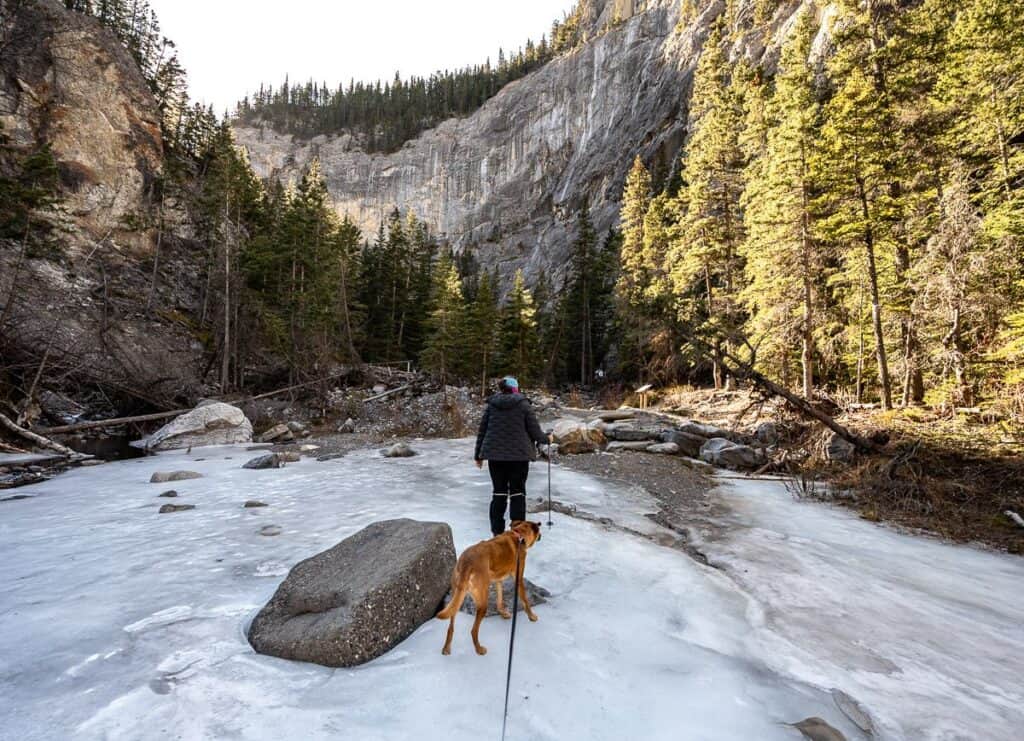
In winter, there is a section of Heart Creek you must walk on. It was a tad slushy in February when we did it – but the water isn’t deep.
Starting out on the Heart Creek Trail – in February
Lots of hikes start on the Heart Creek Trail
Our dog heading for the first of seven bridges over Heart Creek
An icy trail in the shade – with good views across to the Heart Mountain Horseshoe
Good skaters might have fun on a few of these icy stretches
Waterfalls to the end of the trail
The waterfall section is beautiful. It’s worth scrambling over boulders to get close to it – at least in winter.
Continue to the end of the trail where the canyon narrows to about two feet. There are three benches here – should you need a break before you retrace your steps to the parking lot.
We were shocked by the size of the frozen waterfalls
Canyon walls narrow at the end of the Heart Creek Trail
There are a couple of good-sized benches at the end of the trail
My favourite part of the Heart Creek Trail
This is the only section immediately adjacent to Heart Creek where we wondered about the trail location
Tips for Hiking Heart Creek Trail
Pack the 10 hiking essentials even though it’s an easy hike
Once there is any ice on the trail take a hiking pole and wear microspikes
It’s cooler in the canyon so include an extra layer or two
Take a litre of water
Lots of debris leftover from the 2013 flood near one of the last bridge crossings
Heart Creek Trail FAQ’s
Yes though I highly recommend microspikes and a hiking pole to keep you upright.
Yes, but they must always be on a leash.
If there has been a hard freeze, and the waterfalls are solidly frozen, then they should be able to play along its base. But once the icefalls start to melt, chunks of ice could fall off at any time.
Frozen waterfalls are disappearing quickly in February 2026
Heart Creek Trailhead and Parking Information
From Calgary
From downtown Calgary, it’s less than an hour’s drive to the trailhead. Take the Trans-Canada Highway heading west for 87 km.
Get off at exit 105 onto Range Road 91A.
Go left, cross over the Trans-Canada Highway. Then you make a weird left turn – to get to the trailhead which will all make sense and be obvious once you’re there.
Continue straight to the Heart Creek Parking Lot. This is a fun hike to do on the way to or from Canmore as it’s quick and easy!
From Canmore
From Canmore get on the Trans-Canada Highway and follow it for 14.4 km to reach the Lac des Arcs exit.
Get off at exit 105.
Continue straight to the large Heart Creek Parking Lot.
Parking area
It’s a large parking area but it fills quickly on weekends especially – in part because the Heart Mountain Horseshoe Hike and Heart Creek Bunker Trail also start from here.
There are toilets, along with a few picnic benches, and signage to get you on the right trail.
A busy Heart Creek parking lot on a winter weekend
Hikes Near the Heart Creek Trail
The Sparrowhawk Tarns Hike near Canmore – A rewarding hike near Canmore that leads to beautiful alpine tarns and expansive mountain views.
The Prairie View Trail – Jewell Pass Hike – A popular Kananaskis hike offering a steady climb, wide-open views, and a rewarding viewpoint at the top.
The Fantastic Hike to the Summit of Ha Ling Peak – A steep, rewarding hike near Canmore offering panoramic views over the Bow Valley.
The Demanding Hike up Yamnuska is Full of Surprises – A demanding hike with an airy short chains section and a steep descent along with phenomenal views.
The Baldy Pass Trail in Alberta’s Kananaskis Country – A classic Kananaskis hike with steady elevation gain, and expansive views along the Continental Divide.
Click on the photo to bookmark to your Pinterest boards.
The post Heart Creek Trail Near Canmore – A Fun Canyon Walk in Any Season appeared first on Hike Bike Travel.