The popular Stanley Glacier hike offers three very different experiences. Most people simply hike 4.2 km into the valley basin, enjoying panoramic mountain views and lunch where the maintained trail ends. Others will continue for about 2.2 km to reach the upper basin – via a trail through the scree that heads for the cliffs and does a loop back. And a smaller group will sign up for one of the guided Burgess Shale hikes with Parks Canada. It stops just shy of where the maintained trail ends.
I have done all three routes and can say there is no best way to do the Stanley Glacier hike. Choose a route that fits with your fitness level and interests (hunting for fossils), glaciers (do the full loop), or simply stop and enjoy the views at the end of the maintained trail.
This post includes some affiliate links. If you make a qualifying purchase through one of these links, I will receive a small percentage of the sale at no extra cost to you. Thank you very much for your support.
Stanley Glacier hike summary
Distance: Approximately 8.8 km return to the end of the maintained trail and back. Add at least another 4.4 km to hike close to the toe of the Stanley Glacier.
Elevation gain: Approximately 385 m but up to 820 m (2,690 feet) if you hike to the toe of the Stanley Glacier.
Type of hike: Out and back with the option of doing a loop extension to the toe of the Stanley Glacier.
Time needed: 3 – 4 hours for the Stanley Glacier hike if you turn around at the end of the maintained trail; add a few more hours if you scramble up to the toe of the Stanley Glacier and back.
Level of difficulty: Easy to the easy side of moderate depending on how much you hike. It’s hard up to the toe of the Stanley Glacier because of loose scree, steep sections, and stream crossings.
Dogs allowed: Yes, if on a leash.
Best season: Late June until late September or whenever the snow flies. You don’t want any snow on the ground if you’re looking for fossils and it can stay around until mid-June.
Trailhead: The Stanley Glacier trailhead is on Highway 93, just a 3-minute drive from the Marble Canyon Campground and hike in Kootenay National Park. It’s also only a few minute’s drive from the Alberta border.
Permit: You need a National Parks pass to stop in Kootenay National Park. The Discovery Pass is your best value if you plan on spending more than a week in the national parks. Count on $11 per day per adult and $9.50 per day for those 65 and older. Youth, 17 and younger are free.
Don’t forget: Let someone know where you’re going, practice Leave No Trace principles and always pack the 10 hiking essentials.
Bears: I would recommend carrying quick to access bear spray and pack it in abear spray holsterso you don’t accidentally set it off. Occasionally bears are spotted in the upper basin. If you’re unfamiliar with what to do when you see a bear read Tips for Staying Safe in Bear Country.
Weather: Check the weather forecast for Kootenay National Park before you head off.
Cell coverage: Don’t count on any cell service on the Stanley Glacier hike.
Map: For an offline hiking app I like Organic Maps andGem Trek Kootenay National Parkfor a paper map.
Tours: If you don’t want to hike the Stanley Glacier trail alone, sign up for one of thehalf day toursoffered by Viator.
You can look for fossils on the Stanley Glacier hike but don’t take any with you
Finding the trailhead for the hike
The parking lot for the Stanley Glacier hike is well signed in either direction on Highway 93. It’s just 3.5 km south of the Continental Divide sign or 3.9 km north of the Marble Canyon trailhead in Kootenay National Park.
Even though there is room for over 30 cars, it fills quickly, especially on summer weekends. Be prepared to park alongside the highway. Be very careful as truck whiz by at high speeds. Make sure your park pass is visible so you don’t get a ticket.
There is one outhouse in the parking lot and that’s it for services.
If you don’t want to park on the highway, check out the nearby Boom Lake hike or Arnica Lake hike.
The parking lot at 10:15 AM for the Stanley Glacier hike looked like this on a sunny summer weekend – with many vehicles parking along Highway 93
Parks Canada guided hike experience to the fossil beds below Stanley Glacier
Book a reservation starting on January 23, 2024 at 8 AM MST for the guided tour to the fossil beds.
“You could get lucky finding something new” exclaims Claudia Herding our Burgess Shale guide who is leading us on the Stanley Glacier hike in Kootenay National Park.
We are a group of seven people: Claudia our guide, two women from the Red Deer hiking club including 75 year old Bertha; Alan, an English fellow living in Detroit; his 79-year-old father from England, myself and a woman who has come along as a sweep.
It was a dreary Monday morning on the last day of August when we met to do the Stanley Glacier hike at the Stanley Glacier parking lot in Kootenay National Park – located just 15 km south of Castle Junction on Highway 93. At 6°C I wasn’t sure if we’d be snowed or rained upon, but no matter what we were all keen on the Stanley Glacier hike in search of fossils.
Our goal was a hard-to-miss large boulder, possibly an erratic – accessed via a 200 m section of rocky trail up in the hanging valley. In the vicinity of this rock are loads of tiny fossils that make up the Burgess Shale. The guided tours to this area started in 2014 as fossils were discovered as recently as 2008.
Fossils to look for on the Stanley Glacier hike
All told between hiking and fossil hunting we were out for about seven hours on the Stanley Glacier hike. Claudia showed us some of the fossils we might find along with photos of what they probably looked like. Then we were sent off to see what we could find.
For the first half hour I found nothing but pretty rocks. But once I understood the scale of what I was looking for I found loads of tiny fossils. It ended up being far more fun once I knew exactly what I was doing.
Should you do the Stanley Glacier hike with a guide?
Although you can do the Stanley Glacier hike on your own (whereas you can’t do the Burgess Shale hikes on your own in Yoho National Park) and most people do, you learn so much more with a knowledgeable guide like Claudia.
The Stanley Glacier hike costs $54.47 to $80.11 in 2024 depending on your age plus $11.50 for a non-refundable reservation fee. Go prepared no matter what hike you do – as they run rain or shine.
There are two other Parks Canada guided Burgess Shale hikes you can sign up to do in Yoho National Park – though they are longer and more strenuous.
Recommended reading: The Burgess Shale Hike in Yoho National Park
Stanley Glacier hike description to the end of the maintained trail
The Stanley Glacier hike starts by crossing the Vermillion River on a well-constructed bridge. From there follow long switchbacks up the hill – stopping to admire Stanley Creek with its lengthy and impressive cascades. There are some good views south in Kootenay National Park as you near the end of the switchbacks.
After crossing Stanley Creek on a bridge around the 2 km point, the trail flattens for a short time and then proceeds at a moderate grade until it reach the talus slopes. Views open up and you can see the tongue of the Stanley Glacier off in the distance.
You also can’t help but notice the massive rock wall on your right as you head up the trail. You may see rock climbers on it, especially if you’re hiking on a weekend. Also look for people on the scree slopes hunting for fossils.
When you reach a junction, go left and hike steeply for a few minutes. You’ll come out on a flattish section in the trees near the end of the maintained trail. It’s a good turn around point for many and a lovely place to enjoy lunch.
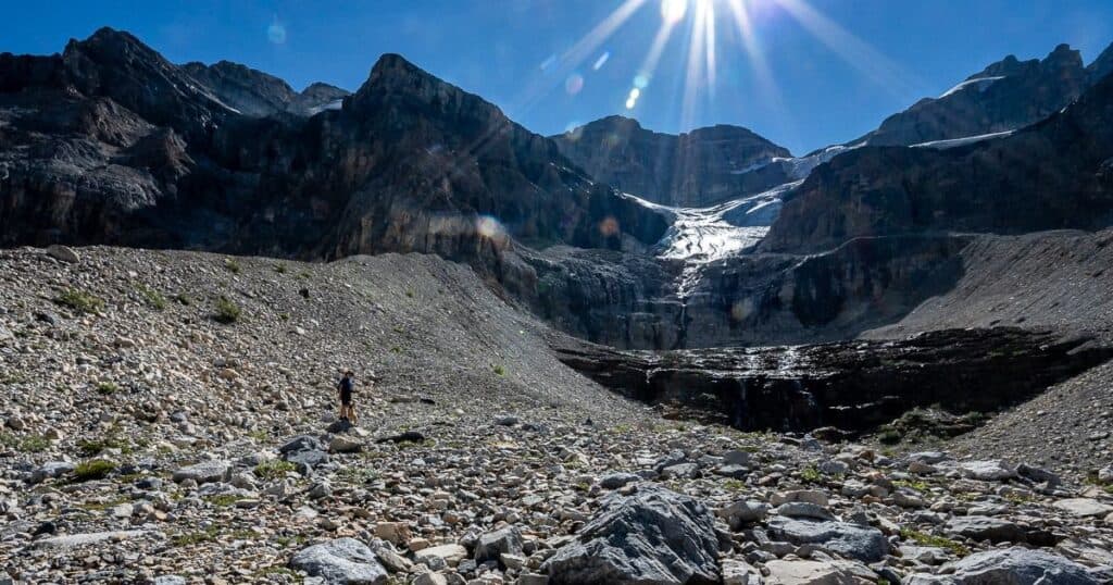
Loop extension to the toe of the Stanley Glacier
If the first part of the Stanley Glacier hike up to the end of the maintained trail exceeded your expectations, then you will truly be wowed by the loop extension.
On a September Labour Day weekend we chose to do the loop in a counterclockwise direction – first heading for the big cliffs. The unmaintained trails, save for a short scree section on the loop back are in excellent shape. I would recommend hiking poles though.
We made our way towards the headwall where you’ll find a set of waterfalls and a cave near their base. It’s very scenic and the spray on a hot day is welcome. You can clamber into the cave and enjoy a scenic view out.
Continuing on you must cross a creek. Fortunately in September it was an easy walk across, but early in the season with all the snow melt, it could be a problem. Again, a place for hiking poles.
Head towards the forest – enjoying superlative views of Mount Whymper at the end of the valley along Highway 93. We found a spot in here to eat lunch before continuing up the scree towards the Stanley Glacier.
If you don’t drop down to the forest, you can pick out a rough trail on a lateral moraine heading up to the Stanley Glacier. Follow it as it winds to within a 100 m of the glacier. We did not take that trail but headed off trail across scree climbing to a bench below the waterfalls coming off the glacier. In hindsight, we should have stayed high and got up closer to the glacier.
The descent
After lunch and some exploring we started back for the car by descending on an obvious trail that was made up largely of scree. I found this to be the hardest part of the Stanley Glacier hike, as some of the scree was the ball-bearing type – and predictably I fell once on my rear.
There was also plenty of thick scree that you could easily walk down, but it was tiring and you really had to focus. It was a treat to get back into the shade of the trees, though we made a stop so my geologist husband could look for fossils. We was very pleased to find the trilobite pictured below.
What to take on the hike
In late August I was very happy to have a hat and mittens on the Stanley Glacier hike. I would also recommenda seat cushionso you have something dry and comfortable to sit on, especially if you’re doing the guided tour.
Take lots of water, especially on sunny, hot days. You might want to carrywater purification tabletsin case your run low.
A pair oftrekking poles come on handy on the Stanley Glacier hike, especially if you plan to go to the toe of the Stanley Glacier.
Where to stay near the trailhead
There is camping at nearby Marble Canyon Campground. It is open and reservable from June 20 – September 2, 2024. There are 60 unserviced sites best suited for tents and small RV’s.
The closest lodging is Storm Mountain Lodge in Banff National Park. It’s only about a 7-minute drive away. It’s also a spot to grab drinks, snacks and even a meal at the end of the hike.
Castle Junction is also close by. There you could stay at theCastle Mountain Chalets, Johnston Canyon Lodge & Bungalowsor theCastle Mountain Hostel.
Baker Creek by Basecamphas a great location on the Bow Valley Parkway. Enjoy fire pits by the creek.
In Banff itself, I like theMoose Hotel & SuitesandBuffalo Mountain Lodge.
Further reading on hiking in Banff and Kootenay National Parks
8 Easy Invermere, BC Area Hikes
Backpacking the Rockwall Trail – Kootenay National Park
The Boom Lake Hike in Banff National Park
The Helen Lake in Banff National Park
18 of the Best Banff Hikes You Can Do in a Day
Click on the photo to bookmark to your Pinterest boards.
The post Stanley Glacier Hike, Kootenay National Park appeared first on Hike Bike Travel.