Kananaskis Country is one of the best places in the Canadian Rockies for hiking, especially if you love ridge walks. Instead of climbing to a single summit and turning around, some ridge hikes deliver kilometres of continuous views, often with sweeping vistas over valleys, mountain peaks, and alpine lakes. Granted some ridge hikes are out and back but many can be done as a loop or with a car shuttle.
Some ridge hikes in Kananaskis close to Canmore take only a half day, while others like the infamous Northover Ridge rank among the most spectacular multi-day backpacking routes in the Rockies. Many also melt out earlier than alpine summits – including Wasootch Ridge and Porcupine Ridge, making them excellent early-season hikes starting as early as May.
In this guide you’ll find the best ridge hikes in Kananaskis Country, Alberta – all personally tested, from beginner-friendly ridges like Raspberry Ridge to long, dramatic outings like Centennial Ridge and the Tent Ridge Horseshoe. I’ve included trailhead details, distance, elevation gain, exposure levels, and tips so you can pick and plan the ridge hike that is right for you.
This post includes some affiliate links. If you make a qualifying purchase through one of these links, I will receive a small percentage of the sale at no extra cost to you. I very much appreciate your support.
Looking down to the Opal Ridge South trail
What Is a Ridge Hike?
A ridge hike is one that follows the crest of a mountain ridge – sometimes ending at a ridge summit or high point. These hikes offer near continuous sweeping views, but they may also involve strong winds, electrical storms, especially on summer afternoons, scrambling, and exposure.
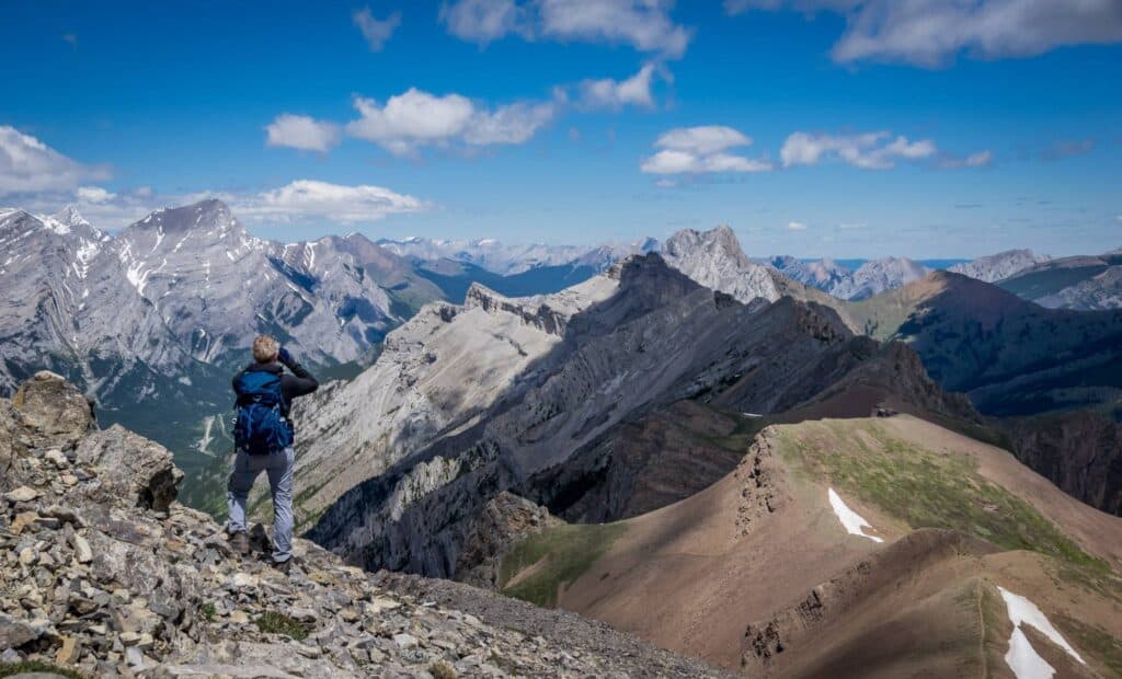
Lunch spot and turnaround point for most people on the Porcupine Ridge hike
Why Ridge Hikes in Kananaskis Are So Special
In my opinion, what makes the ridge hikes in Kananaskis so special is that they are very accessible from the Canmore – Calgary corridor and the views are comparable to some of the best Banff National Park mountain scenery. On many of the ridge hikes you’ll enjoy hours above tree line with 360-degree views.
John enjoying an airy view off the Mount Allan summit at the end of Centennial Ridge
Quick Guide to Ridge Hikes in Kananaskis
Longest ridge hike: Mist Ridge
Early season ridge hike: Porcupine Ridge, Raspberry Ridge, Wasootch Ridge
Best ridge hike for larches: Pocaterra Ridge
Best beginner ridge hike: Raspberry Ridge (once the cornice is melted)
Best views: Centennial Ridge and Northover Ridge
Best short ridge hike: King Creek Ridge
Best ridge loop: Tent Ridge Horseshoe
Good ridge hike in winter: Wasootch Ridge, Gypsum Ridge
Least busy ridge hike: Mist Ridge, Grizzly Ridge
Amazing ridge walking for hours on the Tent Ridge Horseshoe in Kananaskis
How to Choose the Right Ridge Hike
If you’re new to ridge hiking, start with shorter or less exposed routes. Move on to harder and more exposed ridge hikes after gaining confidence and experience. You will need a Kananaskis Conservation Pass to do any of these ridge hikes.
Beginner-friendly ridge hikes
Raspberry Ridge
Powderface Ridge
Jumpingpound Ridge
Moderate ridge hikes
Pocaterra Ridge
Wasootch Ridge
Wind Ridge
Challenging ridge hikes
Centennial Ridge
Opal Ridge South
Northover Ridge
Map of the Best Ridge Hikes in Kananaskis
The ridge hikes in Kananaskis are all on the map – but not all pins are entirely accurate. Use this as a guide. I have also included parking where I could find it.
Best Ridge Walks in Kananaskis
I have personally hiked all the ridge walks listed below over many years. What makes Kananaskis Country special is the number of accessible ridge hikes compared with nearby Banff National Park – where most hikes typically lead to a beautiful alpine lake or mountain peak. In Kananaskis you can often enjoy long stretches of ridge walking with expansive views for most of the way.
Ridge Walks From Highwood Pass
1. Pocaterra Ridge
Provincial Park: Peter Lougheed Provincial Park
Trailhead: Highwood Pass parking lot
Distance: 9–10 km one way
Elevation gain: ~600 m
Difficulty: Moderate
Scrambling/exposure: None
Time needed: 5 – 7 hours
The Pocaterra Ridge hike is one of the best Kananaskis hikes – but also one of my personal favourite ridge walks, especially in larch season. The 10.5 km one way hike follows an undulating ridgeline over four summits and delivers non-stop mountain views. It’s best done one way with a car shuttle. In larch season plan to be at the Highwood Pass trailhead very early on a weekend so you can snag a parking spot.
Pocaterra Ridge in larch season is amazing
2. Grizzly Ridge
Provincial Park: Peter Lougheed Provincial Park
Trailhead: Highwood Pass parking lot
Distance: 9.6 km return
Elevation gain: 683 m
Difficulty: Moderate
Time needed: 4.5–6 hours
Scrambling/exposure: Minor and very short
The Grizzly Ridge hike starts like many others – including Ptarmigan Cirque, at Highwood Pass. It shares the same trail as Pocaterra Ridge for the first few kilometres. At an intersection turn left and hike up Grizzly Col before continuing up to Grizzly Ridge. Once atop the ridge turn left and follow it to its high point, delighting in the panoramic views of Paradise Valley and the surrounding peaks in Peter Lougheed Provincial Park.
Heading for the Grizzly Ridge summit in Kananaskis
Ridge Walks off Southern Highway 40
3. Mist Ridge
Provincial Park: Elbow Sheep Wild Provincial Park
Trailhead: Start at the parking lot at Mist Creek Day Use-area
Distance: 14.8 km return to ridgecrest; 23 km circuit
Elevation gain: 716 m to ridgecrest, 1058 m on circuit
Difficulty: Moderate to challenging depending on distance
Time needed: 7 – 8 hours
Scrambling/exposure: None
It takes about two hours of hiking to reach the south summit of Mist Ridge where the real ridge walking starts. From there follow the ridge as an out and back to the ridgecrest or hike the full undulating Mist Ridge and drop down at Rickert’s Pass to the Mist Creek Valley trail for an easier and faster hike out. There is nothing technical along Mist Ridge.
Any time spent on the ridge is a treat, especially when the summer wildflowers put on their show. It’s a quiet hike and you probably won’t see more than a few people. But you might see a bear so go prepared. We saw a black bear and two cubs on the approach.
4. Raspberry Ridge
Provincial Park: Not applicable
Trailhead: 11.4 km west of Highwood Junction
Distance: 9.0 km return
Elevation gain: 653 m
Difficulty: Moderate
Time needed: 3 – 4.5 hours
Scrambling/exposure: None
The Raspberry Ridge hike in the Highwood Junction area is a short easy ridge walk. It offers a great workout and stunning views without the crowds. Located off Highway 940 in Kananaskis Country, Raspberry Ridge is ideal in spring, and by mid-May, once most of the snow has melted, it’s one of the best early-season hikes in Alberta.
Raspberry Ridge is one of the early season ridge hikes in Kananaskis you can do
Northern Highway 40 to Trans-Canada Highway
5. Porcupine Ridge
Provincial Park: Elbow Sheep Wildland Provincial Park
Trailhead: Beside Highway 40 where it meets Porcupine Creek
Distance: 9.2 km return
Elevation gain: 713 m
Difficulty: Hard
Time needed: 4.5 – 6 hours
Scrambling/exposure: Optional – moderate and very short at the VERY end of the ridge
The Porcupine Ridge hike is a challenging one – but a rewarding one with truly exceptional views after you break through the trees, about an hour into the hike. There are a few places with exposure and the final climb to the top of Porcupine Ridge on exposed slopes is one many will want to forgo. The hike is a surprisingly good one starting sometime in May – after most of the snow has disappeared.
John and our dog admiring the view from the Porcupine Ridge hike in Kananaskis
6. Wasootch Ridge
Provincial Park: Elbow Sheep Wildland Provincial Park
Trailhead: Wasootch Ridge Day-use Area
Distance: 11 km return to the cairn
Elevation gain: 762 m
Difficulty: Moderate to difficult
Time needed: 4 – 6 hours
Scrambling/exposure: Very minor exposure for seconds
The Wasootch Ridge Trail is a popular hike in Kananaskis especially early in the season as it loses snow before many other trails. It’s a favourite hike for people in the Calgary – Canmore corridor as not only is it close by but it delivers a fun, lumpy ridge walk with knock-out views. As with many hikes along Highway 40, it’s a steep one.
A perfect March day to be hiking Wasootch Ridge
7. Centennial Ridge – Mount Allan
Provincial Park: Bow Valley Wildland Provincial Park
Trailhead: Ribbon Creek
Distance: 14.6 km return
Elevation gain: 1,347 m
Difficulty: Hard
Time needed: 7 – 10 hours
Scrambling/exposure: Small amount of downclimbing – you may need to be spotted
One of the most dramatic ridge hikes near Canmore, the Centennial Ridge hike climbs steadily to the summit of Mount Allan. The long ridge walk has loads of interesting features including the Mushroom Garden, a section of down scrambling, the superlative views from the top of Mount Allan – and the ability to turn the hike into an epic outing by continuing over the top and down to Dead Man’s Flats – where you will have left another car. Pick a good weather day as this ridge is no place to get caught in a thunderstorm.
The long, fabulous Centennial Ridge hike
8. Opal Ridge South
Provincial Park: Elbow Sheep Wildland Provincial Park
Trailhead: North end of the parking lot at the Fortress gas station
Distance: 8 km return
Elevation gain: 1012 m
Difficulty: Challenging especially with steep scree
Time needed: 4 – 6 hours
Scrambling/exposure: Some scrambling – fine if you are used to loose steep scree, otherwise avoid
The Opal Ridge South hike is a challenging Kananaskis hike that requires comfort on steep loose scree but the rewards are many. The ridge walking is superlative – offering views of valleys few hikers ever see. You may see bighorn sheep – and you will definitely feel a sense of awe with the breathtaking mountain views south along Highway 40 and beyond.
Mid-June on Opal Ridge South in Kananaskis Country
9. King Creek Ridge
Provincial Park: Peter Lougheed Provincial Park
Trailhead: Off Highway 40, just north of the King Creek Day-use parking area
Distance: 7.0 km return
Elevation gain: 731 m
Difficulty: Hard
Time needed: 4 – 5 hours
Scrambling/exposure: Very short section at the far end of King Creek Ridge
The steep King Creek Ridge hike off Highway 40 in Peter Lougheed Provincial Park, Kananaskis Country offers exceptional mountain scenery. However, the hike is not a beginner hike thanks to a long section of steep scree before you gain the ridge. Once on the ridge the hiking is lovely though to its finish. I really felt like I was walking through the Swiss Alps once on the ridge.
You may want to yodel on the fabulous King Creek Ridge hike
Spray Lakes – Smith Dorrien Road
10. Gypsum Ridge
Provincial Park: Peter Lougheed Provincial Park
Trailhead: On Highway 742, 150 m SE of the Blackshale Suspension Bridge trailhead
Distance: 6.2 km return
Elevation gain: 504 m
Difficulty: Hard
Time needed: About 3 hours
Scrambling/exposure: No scrambling but minor exposure on the optional hike out to the end of the ridge
The Gypsum Ridge winter hike starting from Highway 742 exceeded any expectations I had. It’s got a bit of everything – a very steep climb, forested sections with occasional views, and a final ridge walk to a marvelous airy viewpoint over Kananaskis Lakes. It’s a quiet, unofficial trail with no signage or formal trailhead. It’s the perfect half-day hike for experienced winter hikers, snowshoers, and dog walkers. I have yet to do it without snow.
The hike to the end of Gypsum Ridge is an airy one
11. Tent Ridge Horseshoe Loop Hike
Provincial Park: Spray Valley Provincial Park
Trailhead: 1.5 km up Mount Shark Road from the Smith Dorrien Road
Distance: 10.6 km loop
Elevation gain: 780 m
Difficulty: Hard
Time needed: 5 – 6 hours
Scrambling/exposure: A few scrambling moves near the start of the ridge climb going clockwise and minor exposure along some sections of the ridge
The Tent Ridge Horseshoe Loop is one of the most top ridge hikes in Kananaskis Country. The 10.6 km loop features light scrambling, a short section with dramatic exposure (especially when you have a dog with you), and continuous 360-degree views over the Spray Lakes Reservoir, Mount Smuts, and the Spray Valley.
Superlative views on the Tent Ridge hike In Alberta
12. Northover Ridge Loop Hike
Provincial Park: Peter Lougheed Provincial Park
Trailhead: North Interlakes Day-use Area
Distance: 33.7 km
Elevation gain: 1180 m
Difficulty: Challenging
Time needed: 11 hours minimum or a 2 – 3 day backpacking trip
Scrambling/exposure: Easy scrambling but big exposure and not recommended if you are uncomfortable with an airy ridge walk
The Northover Ridge loop hike is usually done as a two to three day backpacking trip after the snow has left. You’ll see runners doing it every summer over a day, but very few hikers would attempt it. It’s challenging as there is route-finding and scrambling required. The 2.7 km long Northover Ridge is sometimes only shoulder-width wide – so if you loathe exposure give this Kananaskis ridge hike a pass.
There are rewards – and plenty of them including beautiful Aster Lake, incredible Rocky Mountain views that few people will ever see, the satisfaction of completing the Northover Ridge in one piece, and looking down from the headwall on the Three Isle Lake hike part of the hike.
An airy section of Northover Ridge in Kananaskis
Near Dead Man’s Flats
13. Wind Ridge Trail
Provincial Park: Bow Valley Wildland Provincial Park
Trailhead: Via Exit 98 to Dead Man’s Flats from Trans Canada Highway to parking lot beyond Banff Gate Mountain Resort
Distance: 12.8 km return
Elevation gain: 860 m
Difficulty: Hard
Time needed: 4 – 6 hours
Scrambling/exposure: One short scrambling move
The Wind Ridge Trail near Dead Man’s Flats is a steep, rewarding day hike thanks to wildflower-filled meadows and stunning ridgeline views of the Bow Valley. There is a short scramble to Wind Ridge most regular hikers can manage – and if not you can still enjoy the hike to Windy Viewpoint.
At the end of the Wind Ridge Trail look over to the Windtower, Mount Allan, Mount Lougheed, West Wind Pass and the Rimwall Summit as examples.
The Wind Ridge Trail near Dead Man’s Flats
Bragg Creek Area
Note that Highway 66 is closed from the winter gate near the Elbow Falls parking area from December 1 -May 14th every year.
14. Nihahi Ridge
Provincial Park: Kananaskis Country Public Land Use Zone (PLUZ)
Trailhead: About 10 minutes walk past the Elbow River campground
Distance: ~10 km return
Elevation gain: 735 m/ 2410 feet
Difficulty: Moderate to hard depending on how far you hike along Nihahi Ridge
Time needed: 3- 5.5 hours
Scrambling/exposure: If you continue along Nihahi Ridge you will be scrambling with exposure. Turn back when uncomfortable.
The Nihahi Ridge hike in Kananaskis Country is a moderate to hard trail that rewards with expansive ridge-top views over the Elbow River Valley. Starting near Little Elbow Campground, about 30 minutes from Bragg Creek, this hike climbs steadily through forest and meadow before reaching an airy ridge. Once on the ridge you must decide how far you want to hike. It gets harder the further you go along it. Most people turn back once it gets the least bit tricky.
Our son on Nihahi Ridge
15. Powderface Ridge
Provincial Park: Kananaskis Country Public Land Use Zone (PLUZ)
Trailhead: Multiple options – Highway 66 (start of Powderface Trail), Powderface Trail Road, Powderface Creek Trail
Distance: 4 – 14 km depending on route
Elevation gain: 400 – 700 m (depends on route)
Difficulty: Moderate
Time needed: 2 – 5 hours
Scrambling/exposure: None
The Powderface Ridge hike near Bragg Creek offers the option to start at several different trailheads. The approach is steep off Highway 66, moderate off the Powderface Trail Road and Powderface Creek Trail. The most direct and popular route is off Highway 66. The reward – summer wildflowers and great Rocky Mountain views. You can make the hike into a loop with a car shuttle or simply do an out and back.
On Powderface East Ridge summit in Kananaskis
16. Jumpingpound Ridge to Jumpingpound Summit
Provincial Park: Kananaskis Country Public Land Use Zone (PLUZ)
Trailhead: On Powderface Trail (a dirt road), 24 km north of the intersection with Highway 66
Distance: 14.6 km return
Elevation gain: 701 m
Difficulty: Moderate
Time needed: 5 – 6 hours
Scrambling/exposure: None
It’s a 14.6 km out and back hike along the Jumpingpound Ridge Trail to Jumpingpound Summit. Most hikers start from the Lusk Pass parking lot on Powderface Trail, though there is the option to do it as a one way hike with a car shuttle. Once you reach treeline, enjoy grand views of the Fisher Range peaks and massive Moose Mountain. In summer wildflowers are a feature.
Me on the top of Jumpingpound Summit
Tips and Safety Considerations for Hiking Ridges
There are safety issues related to the ridge hikes in Kananaskis Country.
Wind is common on ridge walks. In summer, the wind can be pleasantly cooling but in the shoulder season, it can force you to huddle into a ball. I’d recommend a lightweight down jacket, no matter what time of year you hike.
You’re more exposed to bad weather on any of these ridge hikes in Kananaskis. And sometimes there is nowhere to hide. Check weather reports before heading out for the day. If bad weather threatens, make a hasty retreat. I have had a buzzing ice axe on a high peak with the approach of an electrical storm – and I can tell you I ran off the summit trying to get out of harm’s way.
On some of these Kananaskis ridge walks there is exposure. If you are uncomfortable with scrambling and/or exposure, give the hike a pass.
Up on Powderface Ridge with a threatening storm
Best Time of Year for Ridge Hikes in Kananaskis
Most ridge hikes are at their peak once the snow leaves from as early as mid-May until early October. It will vary from year to year. Some of the ridge hikes are ideal in fall when the larches and colours are at their prime, well others are at their prime in summer wildflower season.
The Pocaterra Ridge hike off Highwood Pass is prime the last 2 weeks of September
More Kananaskis Hikes With Great Views
If you like ridge walks, you might also love these Kananaskis hikes with great views.
Burstall Pass – meadows, glacier views, a braided stream crossing, and classic Rocky Mountain scenery
Ha Ling Peak – stunning views of Canmore and the Bow Valley from on top
South Lawson Peak – breathtaking views of the Kananaskis Lakes and the peaks to the south
Headwall Lakes Hike – reach a fantastic set of lakes with the option to continue up Fortress Mountain
Windtower Hike – sweeping views over the Spray Lakes Reservoir, Canmore, and the Bow Valley
More Alberta Hikes and Backpacking Trips
13 Kananaskis Trail (Highway 40) Hikes With the Best Views – A curated collection of some of the best Kananaskis hikes featuring big scenery and big views.
Easy Kananaskis Hikes Everyone Will Love – A roundup of low-effort, high-reward hikes in Kananaskis Country that are perfect for families, beginners, and anyone looking for beautiful scenery without a big climb.
10 Beginner Backpacking Trips in the Canadian Rockies – A list of beginner-friendly backpacking trips in the Canadian Rockies, focused on achievable distances, established campsites, and scenic rewards.
10 + Best Backpacking Trips in Banff National Park – Check out over 10 tried and tested Banff backpacking trips, taking you through forests, meadows, and past alpine lakes with the Rockies as a backdrop.
10+ Must Do Backpacking Trips in Kananaskis Country – A selection of Kananaskis’ best multi-day hikes personally tested from alpine passes to hidden lakes to one with an airy ridge walk.
Click on the photo to bookmark to your Pinterest boards.
The post 16 Best Ridge Hikes in Kananaskis Country (Epic Views in Alberta) appeared first on Hike Bike Travel.