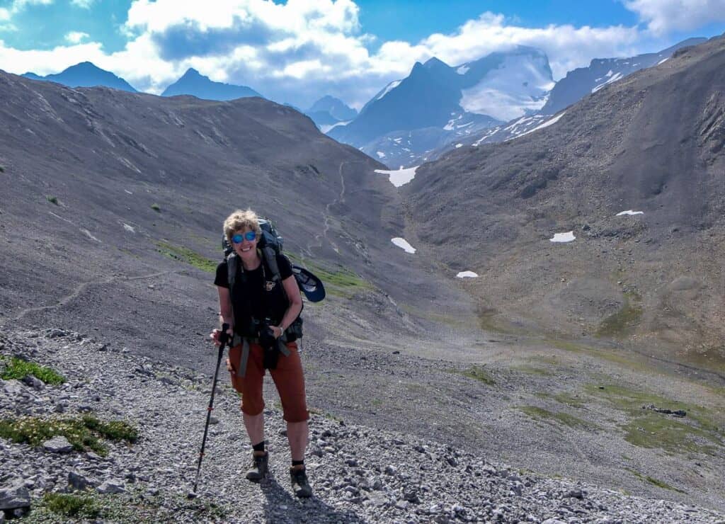
The Northover Ridge Loop hike in Peter Lougheed Provincial Park in Kananaskis has been on my radar for years. I have read lots of trip reports about both the airiness of the Northover Ridge, and the drop-offs that could in theory send you to your death on the way to Aster Lake. This year something changed. I knew physically I could always do the hike, but mentally I felt stronger and decided that 2024 was going to be the year.
Was it hard? Yes, but the hike up to Aster Lake Campground wasn’t half as bad as I imagined it to be. Pay attention, don’t rush and any experienced hiker should be fine. Northover Ridge is another beast altogether, especially carrying a backpack. I was nervous, very nervous – on the narrow sections, but I also knew I could do it. It’s amazing what you’re capable of when there really are no other options but to go forward. That’s just what you do.
But make no mistake. You need lots of hiking and backpacking experience before you set out. If you’ve never climbed on steep scree before, this is no place to start. And if airy hikes give you a bad case of sewing machine leg, then give it a pass.
This post includes some affiliate links. If you make a qualifying purchase through one of these links, I will receive a small percentage of the sale at no extra cost to you. Thank you very much for your support.
Northover Ridge Loop hike summary
Distance: 33.7 km as a loop hike.
Elevation gain: Approximately 1,500 m.
Time needed: Three days as a backpacker or 6.5 – 9 hours as a runner. (The runners blow me away!!)
Location: Peter Lougheed Provincial Park in Kananaskis Country, starting from the parking lot North Interlakes Day Use Area.
Level of difficulty: Challenging. You need lots of mountain experience that includes scrambling to safely do this hike.
A word of warning: We spoke with a ranger on the way out (who was checking permits) and I asked him about injuries on the trail. He told us they happened frequently, mostly with runners, especially as they didn’t have much to fall back on because they travel light. Every year they do rescues – broken legs, hypothermia, falls, so please go very prepared!!
Dogs: Permitted, but I wouldn’t recommend it. Our dog is agile and did fine though the pads on her paws were sore by the time we got to Three Isle Lake. John dealt with her on the Northover Ridge, making a harness out of her leash. She listened closely, and followed his directions but I couldn’t have dealt with her and Northover Ridge at the same time.
Permits: You will need a Kananaskis Conservation Pass. You can purchase one online or at the Kananaskis Visitor Information Centre on Highway 40. Day passes are $15 and yearly is $90.
Camping: Make reservations up to 90 days before your visit online for the Aster Lake and Three Isle Lake Campgrounds. The tarns in BC – where it’s possible to camp, do not require a reservation. There are obvious campsites by the tarns but there are no facilities and nowhere to hang your food. Consider taking a aUrsack bear resistant bag– something we used on our one week Yukon backpacking trip in Kluane National Park.
Map:Gem Trek Kananaskis Lakes. For a hiking app try Organic Maps as it works offline. It’s great at pinpointing your location and keeping you on the right trail.
Wildlife: You’ll be hiking in grizzly bear, moose and cougar country. We didn’t see so much as bear scat but do carry easy to access bear spray. We saw porcupines at both campsites, so keep your hiking boots and poles in your tent as they love to chew (and destroy) salty things.
How difficult is the hike?
The 33.7 km-long Northover Ridge hike is challenging and technical insofar as there is route-finding and scrambling required. (Many people make a wrong turn around Aster Lake.)
The Northover Ridge itself is 2.7 km long, and while the section closest to Aster Lake is wide and easy to hike, there is a long-exposed section that is shoulder-width wide and airier than many will like – myself included. There is nowhere to retreat quickly in the event of a storm.
What is the best time of year to hike the Northover Ridge loop?
August and early September are the best times to hike the Aster Lake – Northover Ridge – Three Isle Lake loop. You want the snow to have melted off the route – and the Aster Creek Canyon to be free of snow – or it’s way too dangerous to hike.
If you go later in August, you’ll also find fewer biting insects around Aster Lake. Typically, the weather too is more stable with fewer thunderstorms. The downside is that there might be smoke – but that seems to occur with such frequency in the summer now, that it’s more a matter of luck.
If you hike in the fall
If you do the Northover Ridge hike in September, you’ll be dealing with fewer daylight hours and more bear activity but chances of a thunderstorm at elevation will be rare.
Try to be spontaneous on this hike as the weather matters. You do not want to be heading up or on Northover Ridge in any type of storm, be it thunder, rain, wind, snow, or hail. There is nowhere to hide on top. Cancel your campsite reservations if the weather forecast is truly bad!!
If you’re concerned about the route’s conditions, call the Kananaskis Visitor’s Centre and ask to speak to someone who can give you an update.
Where should I stay on the Northover Ridge backpacking trip?
Assuming you are not a runner knocking off the full Northover Ridge loop in one longish day, plan to do the hike with a stay at Aster Lake Campground on night one and Three Isle Lake Campground on night two (or vice versa if you go counter-clockwise).
You can book both Alberta Parks campsites online 90 days out.
Some people will hike all the way back to their car from the Aster Lake Campground and knock it off in two days, but I wouldn’t recommend it, unless you’re in amazing shape.
What direction should I hike the Northover Ridge Loop?
I was told by two runners I respect to hike the Northover Ridge in a clockwise direction – though we saw many people doing it the other way.
I think the advantages are that it’s easier going up the exposed scree-rock mix towards Aster Lake rather than down and while it’s very steep coming off Northover Ridge, I think it would be way worse going up with a loaded pack.
Something we all hadn’t considered until after we’d finished the hike is that if you’re right-handed, you will be hiking Northover Ridge with your strongest hand/arm available to negotiate the rocks. It might not count for a lot but when you’re balanced precariously, it counts for something.
Part of the steep section coming off Northover Ridge as we head for Three Isle Lake Campground
Backcountry Hazards on the Northover Ridge
Wild animals like bears or cougars.
Loose and falling rock.
Rapidly rising water and unassisted stream crossings.
Difficult exposed terrain and route finding.
Rapidly changing weather.
Limited or no cell service to access 911.
What should I bring on the hike?
Always take the 10 hiking essentials but because this hike is remote compared to most in Kananaskis – and challenging – I would also recommend that you carry aGarmin InReach Mini 2in case of emergency.
If you have ANY concerns about snow, carrymicrospikes. Hiking polesare incredibly useful, especially collapsible ones you can attach to your pack when you don’t need them.
Awater filteris a must. And lots ofhigh energy protein bars.
It was cold at night even in early August, so don’t forget adown jacket, a cozy hat, and gloves. Take awarm sleeping bagand aninsulated sleeping pad.
Northover Ridge loop hike description – Day 1 – Upper Kananaskis Lake to Aster Lake Campground
Distance: 11.4 km
Elevation gain: Approximately 550 m
Aster Lake Campground facilities: Six tent pads. Pit toilet, grey water disposal, bear lockers, two picnic tables and one bench. Water source is a nearby stream. No fires permitted.
We were hiking by about 10 AM on a perfect August day. As we chose the clockwise loop, we started from the North Interlakes Day-Use area by Upper Kananaskis Lake and took the lower trail by the lake 0.8 km into the hike. (The upper trail heads to the Forks and Three Isle Lake Campgrounds.)
The hiking is easy and scenic for the next 5.0 km as you make your way past the turnoff to the Point Campground, over a bridge spanning Lower Kananaskis Falls to reach the signed turnoff to Hidden Lake.
The trail is rougher and the trees larger and more densely spaced on the way to Hidden Lake. I understand that if it’s been a rainy summer, the water level of Hidden Lake could be high – forcing you into the trees, but we had no such issues and remained on the trail. Above Hidden Lake you’re in forest for about 15 minutes an when you pop out, the tough climbing begins.
Hiking up the canyon on the scree slopes of the west face of Mt. Sarrail isn’t hard per se other than catching your breath, put sections of it are above a big vertical drop – which can be intimidating, though less so on the ascent then the descent in my opinion. Pay close attention to your foot placement as this is no place to fall.
You head up towards a waterfall (see photos below) – cross the stream and then deal with one more obstacle – a shimmy up a wide chimney, or a walk up a green bench and then an easy climb on rocks with good traction to meet up above the chimney. Our dog required a lift to get up the chimney section.
From there you’ll reach Foch Pond where there is a ranger patrol cabin which we didn’t visit. From here on it’s up and down, mostly on dirt trails lined by August wildflowers. Cross over a stream and then zig zag up a rocky cliff beside scenic Fossil Falls gorge and pop out by the bear boxes and picnic tables at the Aster Lake Campground. A little further on towards Aster Lake you’ll find 6 tent pads – though there are really 7 as one has been well used but isn’t numbered.
Aster Lake Campground is a very pretty one
Northover Ridge loop hike description – Day 2 – Aster Lake Campground to Three Isle Lake Campground
Distance: Approximately 11.9 km
Elevation gain: Approximately 630 m.
Three Isle Lake Campground facilities: 16 tent pads, pit toilets, bear lockers, picnic tables. No fires permitted.
Today will be a day to remember. By the time you roll into Three Isle Lake Campground you’ll feel a great sense of satisfaction for making it across Northover Ridge in one piece. For some it will be nothing special as you’re used to airy ridge walks. For the rest of us, it’s a thrill that comes with a real sense of accomplishment.
The hike starts off easily enough as you head for Aster Lake and continue clockwise around it. The trail is narrow so be careful you don’t slip into the lake. Continue across the gravel flats and then start climbing the grassy slopes towards a pass. As the grade starts to moderate look right and you’ll see a gully with a well-trodden path. Take that, but exercise caution as you get near the high point.
Ahead on your left are the two Northover tarns – where you can camp free of charge because it’s in British Columbia. Climb steeply up to Northover Ridge. I boot climbed part of it on snow as it was easier going than the rock. Reach the high point of Northover Ridge at 2,830 m.
The views once on the ridge are glorious. To the west is the Royal Group made up of eight peaks including massive Mount King George and two glaciers. To the east is Mount Lyautey and south is the Mangin Glacier and Mt. Joffre.
Download PeakFinder (it works offline) so you can check out all the mountain peaks from your perch on Northover Ridge.
You’ll be hiking the Great Divide separating BC from Alberta as you make your way along Northover Ridge. The first part was easy enough with minor elevation changes but nothing crazy. The trail early on was wide too.
As we moved towards the narrower part of Northover Ridge – I thanked my lucky stars that we had one of the nicest, non-windy summer days you could ever have. Sheer luck on our part as I’d booked the campsites in May.
As we got closer and closer to the crux of the ridge, my heart beat harder and harder. I was laser focused on foot placemen and made steady progress. I took the time to look around on occasion and curse – and then continued as the easiest way down was continuing forward.
As described by Craig Copeland in “The Premier Trails in Kananaskis Country Near Calgary and Canmore – “at one point you must step from one dinner-plate-size stone to the next, with the earth falling away dramatically on either side.”
After passing the narrowest part of the ridge, the hiking got easier bit by bit. There were more ups and downs before we descended to the pass. From there we descended a steep scree slope that would be truly awful going up.
Continue the descent looking for the trail through the muddy flats that will lead you to Three Isle Lake. I think the route finding through here is also less of an issue going clockwise as you get a good overview of where you’re heading from up high.
Once you reach Three Isle Lake turn right and hike counter-clockwise around the lake to reach a set of stairs going up to the campground. There are two camping locations at Three Isle Lake. Go right at the top of the steps for the closest campsites. If you go left, it’s a 0.5 km walk to the other part of the campground and after a day like today, you probably are ready to sit – and maybe even swim.
Northover Ridge loop hike description – Day 3 – Three Isle Lake Campground to the parking lot
Distance: 10.4 km
Elevation loss: 475 m
If you’re hiking counterclockwise read my blog on the hike to Three Isle Lake.
The hike down to the parking lot from Three Isle Lake Campground took us about 3.5 hours with a snack break at the Forks Campground. I’ve done this route three times now and it never gets old.
Recommended reading: North to South Kananaskis Pass Hike via Turbine Canyon
The descent off the headwall is steep and you do need to take your time as there’s plenty of pea-sized scree to land you on your butt. After 3.0 km reach the Forks Campground. It’s got pit toilets and picnic tables, so it’s the perfect place for a short break.
From the Forks Campground to the parking lot, the trail is very good, mostly flat and fast. Cross the Kananaskis River and then Invincible Creek, 3.8 km from the parking lot. Hike through the Palliser Rockslide and stay high on an old rocky road. Below you’ll see the trail you hiked to Aster Lake. From the intersection on a side trail down too the lower trail around Upper Kananaskis Lake, it’s 2.1 km to the parking lot.
Congratulations. You did it – but would you do the Northover Traverse Loop hike again?
More backpacking trips in Kananaskis Country
North to South Kananaskis Pass Hike via Turbine Canyon
Tombstone Lakes Hike & Camping Trip in Kananaskis
Little Elbow Hike to Mount Romulus Campground
Carnarvon Lake Hike or Backpacking Trip in Kananaskis
Kananaskis Kayaking to the Point Campground (can also be done as a family-friendly backpacking trip)
Click on the photo to bookmark to your Pinterest boards.